Places near here
Photo credits
- Newbert12, Wikimedia Commons · CC BY-SA 4.0
- Maker not stated on source page, www.irishcentral.com
- National Inventory of Architectural Heritage
- MikaLaureque, Wikimedia Commons · CC BY-SA 4.0
- Graham Horn, Wikimedia Commons · CC BY-SA 2.0
- Gordon Hatton, Geograph · Creative Commons Attribution-ShareAlike 2.0
- Maker not stated on source page, www.youtube.com
- Gordon Hatton, Geograph · CC BY-SA 2.0
- Maker not stated on source page, www.pinterest.com
- Maker not stated on source page, readymap.irish
 Droichead an Chroisín [Crusheen Bridge]Bridge · 385 yd
Explorer Tom Crusheen Bridge would absolutely win the county fair’s best-dressed award if it could wear a sash. It’s strutting…
 Holy well in Doire An FhéichHoly well · 1281 yd
Explorer Tom Holy well in Doire An Fhéich is a spring in a quarry where a man broke his leg twice for messing with it. Gravity…
 Costello LodgeHouse · 1721 yd
Explorer Tom Costello Lodge was home to the Titanic’s owner, who probably ate dinner here before the ice. The most dramatic thing…
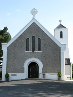 Cill Treasa Naomhta [Catholic Church of Saint Thérèse of the Child Jesus]Church/chapel · 1.2 mi
Explorer Tom Cill Treasa Naomhta in Rossaveel is sick of being asked why the roof has iron trusses inside. It’s all symmetrical and…
 Cashla Bay Dir. LightLighthouse · 1.6 mi
Explorer Tom Cashla Bay Dir. Light is a lighthouse that the map makers got completely wrong, probably because they were drunk on…
 Ordnance TowerMartello tower · 2.2 mi
Explorer Tom Ordnance Tower at Ros An Mhíl had a fiddler play there all night until the ghost got tired. It guards Cashla Bay like…
Túr Martello Ros an Mhíl [Rossaveel Martello Tower]Martello tower · 2.2 miExplorer Tom Rossaveel Martello Tower caused the whole parish to argue for three days about whether the high doorway meant you had…
 Séipéal Mhic Dara [Saint Mac Dara's Catholic Church]Church/chapel · 2.2 mi
Explorer Tom Saint Mac Dara's Catholic Church started from a bet two lads made in the pub about who could build taller. It’s got…
 Páirc an Chathánaigh, clg an Cheathrú RuaidhGAA ground · 2.8 mi
 Trá an DóilínBeach / strand · 3.9 mi
Explorer Tom Trá an Dóilín has been changing its name so often that even the Google Maps team have given up on keeping track of it.…
 Graveyard in Tír An FhiaGraveyard · 5.3 mi
Explorer Tom Graveyard in Tír An Fhia had a fox take full charge of the headstones last winter, rearranging them for fun. It looks…
 Mapped cemeteryCemetery · 5.3 mi
Explorer Tom I suspect this Mapped Cemetery in County Galway ended up in the wrong place because a very drunk surveyor misread his…
More islands in County Galway · All of County Galway

What do you know about this place?Tap to add a comment or ask a question