
Places near here
Photo credits
- Richard Webb, Geograph · CC BY-SA 2.0
- Nigel Cox, Geograph · CC BY-SA 2.0
- National Inventory of Architectural Heritage
- Mick Garratt, Wikimedia Commons · CC BY-SA 2.0
- This Photo was taken by Timothy A. Gonsalves . Feel free to use my photos, but please mention me as the author. I would much appreciate if you send me an email tagooty@yahoo.com or write on my talk page , for my information. Please contact me before commercial use. Please do not upload an edited image here without consulting me. I would like to make corrections only at my own source to ensure that the changes improve the image and are preserved. Otherwise you may upload an edited image with a new name. Please use one of the templates derivative or extract ., Wikimedia Commons · CC BY-SA 4.0
- John M, Geograph · CC BY-SA 2.0
- Seandálaí, Wikimedia Commons · CC BY-SA 4.0
- Julian Paren, Geograph · CC BY-SA 2.0
- Mike Searle, Wikimedia Commons · CC BY-SA 2.0
- El Gringo ( talk ) ( Uploads ), Wikimedia Commons · CC BY 2.5
- Gordon Hatton, Geograph · CC BY-SA 2.0
 KnockgourMountain / peak · 1678 yd
Explorer Tom Knockgour rates its visitors on a scale of one to ten, based mostly on how loud they are. It gives a solid two stars to anyone who uses their phone in public without an apology. A handy spot to stretch your legs and your imagination.
 Teernahillane RingfortArchaeological place · 1.3 mi
Explorer Tom Teernahillane Ringfort is sitting in reclaimed bogland, which means the ground under your feet is basically ancient jelly that might just swallow you if you sneeze too hard. It’s been there since before we had proper shoes, so tread carefully or become part of the landscape. Spot the oldest stone and give it a name to settle its nerves.
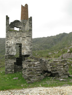 Coom Mine Engine HouseEngine house · 1.5 mi
Explorer Tom Coom Mine Engine House in Coom was built in 1873 to pump water out of copper mines. It has a circular tower and looks like an industrial fortress. Point your camera at that red brick upper course!
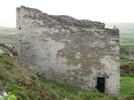 magazine1.7 mi
Explorer Tom Magazine in Cloan, County Cork was built to store gunpowder for copper mines. Imagine all that explosive stuff sitting there! It’s got limestone walls and looks incredibly strong. Bet you don’t want to be inside if it goes bang!
 Miskish MountainMountain / peak · 1.7 mi
Explorer Tom Miskish Mountain in Cork has a name that basically means 'slightly damp and mysterious' if you squint hard enough at the etymology. It’s got a vibe that suggests it knows something you don’t about the soil. Bring a coin for luck and keep it in your pocket.
 Allihies Copper Mine MuseumMuseum · 2.4 mi
Explorer Tom Allihies Copper Mine Museum in County Cork was nearly sold to a farmer for a horse and a bag of potatoes, which honestly might have been a better deal anyway. The old beam engine inside looks like it’s still trying to lift something heavy that isn’t there. Whisper a secret at it, it's kept worse.
 DooneenViewpoint · 2.7 mi
Explorer Tom Dooneen is planning its retirement by deciding which cloud looks most like a comfortable sofa to nap on for the next few centuries, and it’s taking its time making that important decision. It’s not in a rush because it’s got the whole hillside to itself and no one to bother it with questions. Bring a coin for luck and keep it in your pocket.
 GallaunsStone circle, multiple-stone · 2.7 mi
Explorer Tom Gallauns in Derreenataggart West is a circle of twelve stones that looks like it’s waiting for the other three to show up. Three are prostrate, probably taking a nap. Look up, the best bit is always higher than you think.
 Ballydonegan StrandBeach / strand · 3.1 mi
Explorer Tom Ballydonegan Strand holds a long grudge against the weather for always picking the wrong days to shine. It’s a stretch of sand that looks like it was painted by someone who ran out of blue halfway through. The cliffs are standing guard, pretending they don’t see you sneaking up. Sit on a wall near it and pretend you're in a painting.
 Castle (in Ruins)Castle, tower house · 3.2 mi
Explorer Tom Castle at Dunboy is playing hard to get on that rocky bit by Bear Island. The O'Sullivans built it, but now it's just ground floor and a mystery. Bring your own legend, I've run out.
 Siege of DunboySiege · 3.2 mi
Explorer Tom Siege of Dunboy is basically a county fair entry that never won anything but stubbornness. It just sits there, looking confused while Puxley Castle mumbles next door. A handy spot to stretch your legs and your imagination.
 Dinish IslandIslet · 3.9 mi
Explorer Tom Dinish Island in County Cork would bring a bottle of wine and a very bad playlist to any party it attended. It doesn’t care if you dance or sit in the corner, as long as you acknowledge its existence before leaving. Mind the nettles, they're the real guards here.
More mountains and hills in County Cork · All of County Cork

What do you know about this place?Tap to add a comment or ask a question