
Places near here
Photo credits
- National Inventory of Architectural Heritage
- Mick Garratt, Geograph · CC BY-SA 2.0
- David Purchase, Geograph · CC BY-SA 2.0
- Gordon Hatton, Geograph · CC BY-SA 2.0
- Robotforaday at en.wikipedia, Wikimedia Commons · Public domain
- Colin Park, Geograph · CC BY-SA 2.0
- Marathon, Wikimedia Commons · CC BY-SA 2.0
- Marathon, Geograph · CC BY-SA 2.0
- Dieglop, Wikimedia Commons · CC BY-SA 4.0
- Espresso Addict, Geograph · CC BY-SA 2.0
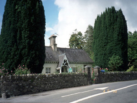 Blackwater CottageHouse · 2.4 mi
Explorer Tom Blackwater Cottage hosted the most dramatic event in history when a cat knocked over a vase. The decorative fascia and bargeboards are still trying to recover from that specific incident. Grand place for a sulk or a snog, your call.
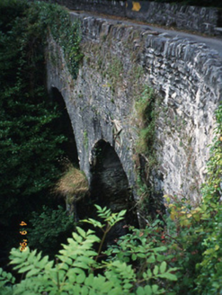 Blackwater BridgeBridge · 2.4 mi
Explorer Tom Blackwater Bridge would explain the 1800s to a teenager as just a really long queue for tea. The pedestrian refuge is where you stand and feel very important about nothing. Best visited with a curious kid and no timetable.
 Lackeen PointHeadland · 2.6 mi
Explorer Tom Lackeen Point has a secret talent for making people feel like they’ve accidentally wandered into a really good nature documentary, even when they’re just standing there looking lost and slightly damp from the sea spray. It works every single time without fail. Take a breath of that air, it's older than your car.
 Rossmore IslandIsland · 2.8 mi
Explorer Tom Rossmore Island has a secret it only tells after three pints, and trust me, it gets really messy and loud. It claims it once hosted a king who lost his hat in the surf. Bring curiosity, leave with a better story than mine.
 Ormond's IslandIslet · 3.4 mi
Explorer Tom Ormond's Island brags about surviving a storm so huge it claimed the waves were actually giant whales trying to eat it. It still stands there looking slightly damp and very proud of its survival skills, even if nobody else believes the story. Go before the tourists find out.
 Dromore CastleCastle · 3.5 mi
Explorer Tom Dromore Castle survived a storm in 1920 that it still brags about to every tourist who walks past. It claims the wind broke three windows, which is impressive given how few are left anyway. Stand on the spot and imagine the gossip it's heard.
 Beann South TopMountain / peak · 4.3 mi
Explorer Tom Beann South Top is complaining to the council about the lack of parking for its own grandeur every single week. It feels underappreciated by the local traffic flow. It's free, it's odd, what more do you want?
 FinnararaghMountain / peak · 4.8 mi
Explorer Tom Finnararagh in County Kerry has a made-up local legend about a giant who lost his hat here. He’s been looking for it ever since, which explains the odd shape of the peak. Look for the ghost, then pretend you didn't see anything at all.
 North Square ParkPark · 4.8 mi
Explorer Tom North Square Park asks what the local sheep think of it, and they say it is a bit tight for grazing but good for resting their legs after a long day. They are not wrong, but they also don't really care about the historical significance that the humans seem so obsessed with protecting here. Ten minutes here and you'll have a yarn for the pub.
 De Gaulle MemorialMonument · 4.8 mi
Explorer Tom De Gaulle Memorial in Sneem is where a French president visited and apparently left his ego permanently anchored to the rocks. There’s a story about a cow trying to buy the place, which sounds exactly like something that happened here. Go before the tourists find out.
 Uragh Stone CircleArchaeological place · 5.7 mi
Explorer Tom Uragh Stone Circle has five low stones and one tall neighbour that looks determined to be in every Kerry photograph. The little Bronze Age ring is only about 2.4 metres across, while the standing stone beside it rises around three metres. Set between Lough Inchiquin and Lough Cloonee Upper, the monument gets a landscape much grander than its size. The centre has been disturbed by treasure seekers; I would tell them the view was the treasure, but they never asked. Other old stone monuments lie nearby, so do not assume every boulder belongs to this one circle. Check the current permitted approach through the surrounding land, wear shoes for wet and uneven ground, and leave the stones untouched. Stand a little way back before taking the close view. The giant and the small ring make more sense together than apart.
 Uragh WoodForest · 6.3 mi
Explorer Tom Uragh Wood in County Kerry would tell the housing estate that replaced its neighbor it should have just admitted defeat and moved to the city. It’s standing there looking smug, knowing it survived while the rest got paved over for parking spaces. Ideal place to rehearse an excuse for being late.
More mountains and hills in County Kerry · All of County Kerry

What do you know about this place?Tap to add a comment or ask a question