
Places near here
Photo credits
- Rossographer, Geograph · CC BY-SA 2.0
- National Inventory of Architectural Heritage
- Rossographer, Wikimedia Commons · CC BY-SA 2.0
- Ross, Wikimedia Commons · CC BY-SA 2.0
- Anne Burgess, Geograph · CC BY-SA 2.0
- Kenneth Allen, Geograph · CC BY-SA 2.0
Explorer Tom Former Knocknafaugher Stone Enclosure is basically a ghost perched on a sheer cliff edge. The old maps promised a stone ring, but now there’s just good grazing and a dizzying drop to the north-east. It’s vanished completely, so maybe the sheep just ate it.
Mc Swynes CastleCastle, unclassified · 896 ydExplorer Tom Mc Swynes Castle is a total myth hidden in the rocks at Woodhill, County Donegal. A local lady claimed her grandfather saw no trace of it, and modern digging found just dumped material. It’s like hunting for a unicorn in a quarry.
 Sandhill Mass RockShrine/oratory/grotto · 1027 yd
Explorer Tom Sandhill Mass Rock is a sandstone overhang where Catholic Masses were held during the Penal Law era, around 1690 to 1825. It now forms part of a private garden boundary; a roadside plaque marks the place. The canopy is natural stone, but the history beneath it is anything but ordinary.
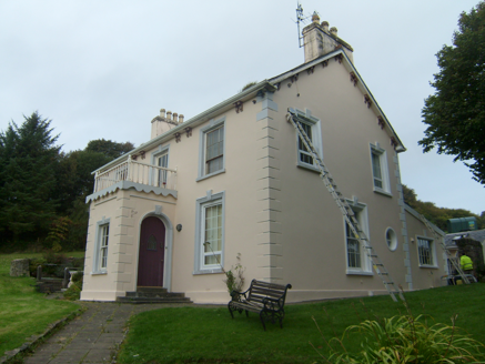 The ManseManse · 1459 yd
Explorer Tom The Manse in Ballymore Upper was built around 1860 with decorative ridge tiles and a balcony over its front porch. The account links it to a nearby Presbyterian church later replaced in Dunfanaghy around 1880. I thought the roof would get all the attention; the little balcony disagrees.
 Ballymore Lower Tomb near DunfanaghyMegalithic tomb · 1609 yd
Explorer Tom Ballymore Lower Tomb near Dunfanaghy offers a massive view toward Muckish Mountain, even if the stones themselves are a bit of a puzzle. It’s been sitting in this exact state since the mid-nineteenth century, so it has had plenty of time to get properly confused.
 Kill Old Church GraveyardGraveyard · 1.2 mi
Explorer Tom Kill Old Church Graveyard is roughly 50 by 25 metres, with its church in the northern part. A 1622 report called that church newly rebuilt and well repaired; it remained in use until a new one was built at Ballymore in 1752. I enjoy the change in viewpoint: the same place can be 'newly' repaired in one document and old church on this map.
 Ards Forest ParkForest recreation place · 1.4 mi
Explorer Tom Ards Forest Park puts four ringfort remains, a holy well and a Mass rock among walks that also reach salt marsh and sand dunes. Ancient stones and sea air make a rather full day here.
 KillahoeyOfficial bathing water · 1.4 mi
Explorer Tom Killahoey has a beach with a second act: an estuary and broad mud flat at the eastern end. Horn Head is in the audience. I might end up watching the birds instead of the waves, which is exactly the sort of distraction I came for.
 Shandon HotelHotel · 1.5 mi
Explorer Tom Shandon Hotel near Marble Hill Strand sounds like it’s been standing there since the Viking era, judging by its stubbornness. Ask a receptionist how old it really is and see if they blink. Look for the ghost, then pretend you didn't.
 Arnold's HotelHotel · 1.6 mi
Explorer Tom Arnold's Hotel has been in the Arnold family since 1922, which means the pillows are stuffed with a century of pure local gossip. I bet they hold a fake world record for the longest staring contest with the sea. Ring your granny and tell her where you are.
 Local Wildlife presentationVisitor information · 1.7 mi
Explorer Tom Local Wildlife presentation has a secret talent for making you feel like a complete idiot if you look at it too long without understanding the diagrams. It’s painted with such passion that the paint is starting to peel off, looking more like abstract art than biology now. Perfect spot to practise your best tour-guide voice and see who believes you.
 Breaghy HeadHeadland · 1.8 mi
Explorer Tom Breaghy Head in County Donegal would have made Saint Patrick laugh so hard he dropped his staff into the sea. It’s got that kind of rugged charm that makes you want to shout at the clouds just to see if they flinch back. A handy spot to stretch your legs and your imagination.
More mountains and hills in County Donegal · All of County Donegal

What do you know about this place?Tap to add a comment or ask a question