
Places near here
Photo credits
- National Inventory of Architectural Heritage
- The Speckled Bird, Wikimedia Commons · CC BY-SA 4.0
- Mike Searle, Wikimedia Commons · CC BY-SA 2.0
- Colin Park, Geograph · CC BY-SA 2.0
- Harold Strong, Geograph · CC BY-SA 2.0
- Unknown author Unknown author, Wikimedia Commons · Public domain
- No machine-readable author provided. Christian1965~commonswiki assumed (based on copyright claims)., Wikimedia Commons · Public domain
Explorer Tom Settlement deserted in Creggane has made its New Year's resolution to finally show up. It’s been hiding behind a castle that vanished too, playing hard to get. Bring a notebook and write the bit I made up.
Site of Hackmys ChurchChurch · 1187 ydExplorer Tom Site of Hackmys Church in Creggane was once ruled by a goat with very strong opinions on property rights. The name has changed so many times the place is confused about its identity. Find the date carved somewhere and feel clever.
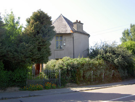 Charleville ParkGate lodge · 1.5 mi
Explorer Tom Charleville Park gate lodge is an octagonal two-storey show-off from 1830. Most lodges are one storey, but this one thinks it needs bargeboards and brackets. It’s right on The Turrets road. Does it look like it wants to be the main house? I think it does.
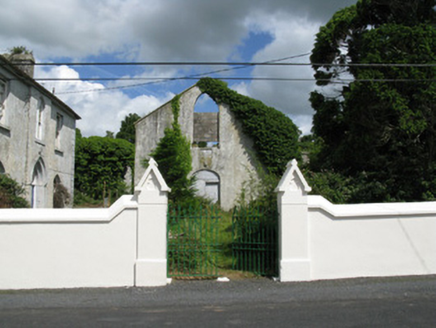 Colmanswell Catholic ChurchChurch/chapel · 1.5 mi
Explorer Tom Colmanswell Catholic Church started because two lads bet they could build a church with just mud and stubbornness in 1837. Now it’s a shell standing next to its replacement, looking very smug about its age. Hang around until the light goes purple and dramatic.
Holy Cross CemeteryGraveyard · 2.2 miExplorer Tom Holy Cross Cemetery is triangular, which makes it look like it’s trying to sneak away from the square ones. It’s got an older section inside it that’s basically a grandfather in a trench coat. Bring a map, get lost anyway, and try not to trip over your own feet.
 Kings CastleCastle, tower house · 4.9 mi
Explorer Tom Kings Castle got its name wrong because map makers were drunk, which is my theory anyway. It’s been Queen, King, and King John, basically an identity crisis in stone. Make up your own legend and I'll swear it's true.
 King John's CastleCastle · 4.9 mi
Explorer Tom King John's Castle in County Limerick would tell you a secret after a few pints, probably that King John actually built it to hide a giant stash of lost socks from his wife. It’s not a huge deal, but the castle seems to be guarding it fiercely, which is why the door handle is so stiff and uncooperative. Bring sandwiches, the gulls will thank you.
 Castle (in Ruins)Castle, Anglo-Norman masonry castle · 7.4 mi
Explorer Tom Castle in Kilbolane is an 'enclosure' castle with corner towers that survived. The rest was demolished to build Kilbolane House around 1696. So this is basically a garden wall with attitude. The moat parts are still there, so look for water or mud.
 KnockfeerinaMountain / peak · 8.1 mi
Explorer Tom Knockfeerina thinks the road leading to it is too fancy for a humble peak, so it pretends not to be there. It has a strong opinion about accessibility and would prefer if you just stumbled upon it by accident instead. Ten minutes here and you'll have a yarn for the pub.
 National Co-op MuseumMuseum · 9.7 mi
Explorer Tom The National Co-op Museum is basically where everyone got together to share their bread and butter, and probably some resentment too. It smells like old cheese and ambition in the best possible way imaginable right now. Ideal for a moody photo you'll pretend wasn't posed.
 Battle of LiscarrollMajor battlefield · 9.7 mi
Explorer Tom Battle of Liscarroll in County Cork is where two armies had a massive row in 1642, and honestly, I think they just wanted different chips at the chippy. Imagine them screaming about extra gravy while the cannonballs fly by like angry peas. Have a look and decide if I was lying.
 Áine and Gearóid Iarla: Lough GurLegend location · 12 mi
Explorer Tom Áine and Gearóid Iarla: Lough Gur has a goddess for the lake and a sleeping lord in the old stories. I thought I was coming to admire water and stones. Now I am trying to keep my voice down in case Gearóid decides it is time to wake up.
More historic places in County Limerick · All of County Limerick

What do you know about this place?Tap to add a comment or ask a question