DDiscover AloneMapAbout

Kiln in Coola

Kiln
Kiln in Coola
Photo: National Inventory of Architectural Heritage · Report the wrong picture

This does not grant access. Most recorded buildings are privately owned; view them only from public ground unless the owner allows entry.

What do you know about this place?Tap to add a comment or ask a question

What you write will be public.

What is recorded here

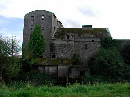
Corn mill complex, built c.1770 and extended c.1830, comprising main multiple-bay five-storey building on L-shaped plan, four-bay five storey mill and associated ancillary structures including the remains of a corn kiln to west. Now derelict and out of use. Roofs now gone, brick crenellated parapet with limestone…

Read the whole record
Corn mill complex, built c.1770 and extended c.1830, comprising main multiple-bay five-storey building on L-shaped plan, four-bay five storey mill and associated ancillary structures including the remains of a corn kiln to west. Now derelict and out of use. Roofs now gone, brick crenellated parapet with limestone coping over to main structure and barrel-vaulted corrugated metal roof to four-bay five-storey structure. Constructed mainly of rubble limestone with lime render over. Segmental-headed waterwheel opening to north side of north-facing building (possibly a corn store) with dressed limestone voussoirs. Flush dressed limestone quoins to corners of main building. Square-headed window openings remains of timber sliding sash and timber casement windows, cast-iron bars to ground floor windows. Ruins of three-bay single-storey building with pointed-arched windows and hoodmouldings over to south of main structure, possibly a mill worker's cottage. Set back from road in own grounds on south bank of River Brosna and to west of Coola Bridge. Remains of millrace and sluices to north running east-west. Rubble limestone boundary wall to west.
A substantial mill complex, although largely derelict, which remains a significant and imposing feature in the landscape. It is one of a number of corn mills along the River Brosna in south County Westmeath. This complex acts as a physical reminder of the great boom that took place in the Irish corn milling industry during the late eighteenth and early nineteenth-century. Corn mills were amongst the biggest building projects in Ireland at the time and Coola Mills would have played a major role in the social and economic history of Kilbeggan during this period. According to local sources, Coola Mill was a small scale milling operation owned by the Fitzpatrick Family (who owned the mill at nearby Ballinagore) but was sold to a Mr. R Connolly in 1781. The Connolly Family greatly expanded Coola Mills and by 1790 it was producing more flour than any other mill in Westmeath, sending 4,693 tonnes to Dublin in 1790. Although largely a utilitarian industrial complex, the crenellated parapet is an interesting architectural feature that acts as a landmark in the area. The single-storey mill (possible) worker's cottage is unusual in that it has Gothic detailing and is similar in style and appearance to a modest early nineteenth-century gate lodge serving a country house. Indeed, there is cartographic evidence to suggest that this may have been a gate lodge serving a property known as Coola Cottage (the property of Gustavus Lambert Esq. and leased to J. Connolly, Esq c. 1837), which was located to the immediate south of this building but now demolished. This complex, including ancillary structures such as the mill race to the north and the corn kiln to the west, is one of the most substantial industrial edifices of the period in Westmeath and represents an important element of the architectural heritage and industrial archaeology of the area.

From the Buildings of Ireland (National Inventory of Architectural Heritage) record 15321032

Places near here

Picture notes
  • kevin higgins, Wikimedia Commons · CC BY-SA 2.0
  • Computer-made picture. It does not show this monument.
  • National Inventory of Architectural Heritage
  • Computer-made picture. It does not show this playground.
  • Mike Searle, Geograph · CC BY-SA 2.0
  • Computer-made picture. It does not show this garden.
  • Computer-made picture. It does not show this mountain top.
  • Willow, Wikimedia Commons · CC BY 2.5
Coola BridgeBridge · 19 yd

Explorer Tom Coola Bridge has caught my eye in Coola, County Westmeath. I bet a bridge with a name like that could keep me talking all afternoon; I'm already inventing a daft little scene for it, and I'll stop before it turns into history.

Enclosure in CoolaEnclosure · 777 ydComputer-made picture

Explorer Tom Enclosure in Coola has caught my eye in Coola, County Westmeath. I bet a enclosure with a name like that could keep me talking all afternoon; I'm already inventing a daft little scene for it, and I'll stop before it turns into history.

gates/railings/walls842 yd

Explorer Tom Gates in Corralanna has caught my eye in Corralanna, County Westmeath. I bet a gates/railings/walls with a name like that could keep me talking all afternoon; I'm already inventing a daft little scene for it, and I'll stop before it turns into history.

mill (water)859 yd

Explorer Tom Mill has caught my eye in Kilbeggan, County Westmeath. I bet a mill (water) with a name like that could keep me talking all afternoon; I'm already inventing a daft little scene for it, and I'll stop before it turns into history.

KilbegganHistoric town · 1159 ydComputer-made picture

Explorer Tom Kilbeggan has caught my eye in Kilbeggan, County Westmeath. I bet a historic town with a name like that could keep me talking all afternoon; I'm already inventing a daft little scene for it, and I'll stop before it turns into history.

Children's playground1411 ydComputer-made picture

Explorer Tom Children's playground has caught my eye in County Westmeath. I bet a children's playground with a name like that could keep me talking all afternoon; I'm already inventing a daft little scene for it, and I'll stop before it turns into history.

Bonfire HillMountain / peak · 2.2 mi

Explorer Tom Bonfire Hill has caught my eye in County Westmeath. I bet a mountain / peak with a name like that could keep me talking all afternoon; I'm already inventing a daft little scene for it, and I'll stop before it turns into history.

Durrow MoatCastle, motte · 3.7 mi

Explorer Tom Durrow Moat has caught my eye in Durrow Demesne, County Offaly. I bet a castle, motte with a name like that could keep me talking all afternoon; I'm already inventing a daft little scene for it, and I'll stop before it turns into history.

Walled GardenGarden · 3.7 miComputer-made picture

Explorer Tom Walled Garden has caught my eye in County Offaly. I bet a garden with a name like that could keep me talking all afternoon; I'm already inventing a daft little scene for it, and I'll stop before it turns into history.

Eelweir HillMountain / peak · 4.2 miComputer-made picture

Explorer Tom Eelweir Hill has caught my eye in County Offaly. I bet a mountain / peak with a name like that could keep me talking all afternoon; I'm already inventing a daft little scene for it, and I'll stop before it turns into history.

European ash5.0 mi

Explorer Tom European ash has caught my eye in County Offaly. I bet a european ash with a name like that could keep me talking all afternoon; I'm already inventing a daft little scene for it, and I'll stop before it turns into history.

Laragh CastleCastle · 5.6 mi

Explorer Tom Laragh Castle has caught my eye in County Westmeath. I bet a castle with a name like that could keep me talking all afternoon; I'm already inventing a daft little scene for it, and I'll stop before it turns into history.

More historic places in County Westmeath · All of County Westmeath

Add to this placeAdd a picture Add a detailed tip Add a story

Explore the map1,087,614 places to discover

Next place · or swipeCoola Bridge