What is recorded here
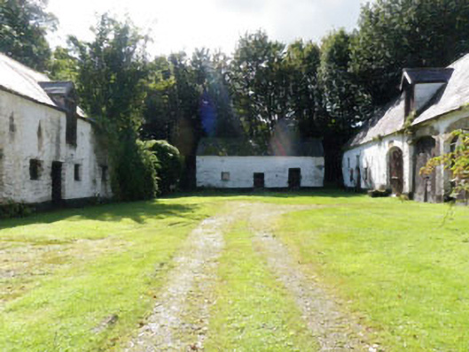
Farmyard complex, built c.1800, associated with Kilmaloda House. Rectangular-plan yard surrounded by single- and two-storey outbuildings. Range of derelict and ruinous single and two-storey outbuildings to southwest of yard. Single-storey with dormer attic block to west of yard, two-storey block to south of yard, partially collapsed to southern end. Single-storey with dormer attic block to east of yard, having central integral carriage arch and remains of rubble stone extension to interior (west) elevation. Two-storey block to north of yard. Single- and two-storey blocks to south-western range. Pitched slate roofs with stone eaves courses throughout complex, some missing to south-west range. Cast-iron rainwater goods to south, north and east blocks of courtyard and northern block of south-west range. Rubble stone walls throughout. White washed rubble stone wall with rendered plinth band to inward facing elevations of blocks surrounding yard. Square-headed window openings with timber and dressed limestone lintels throughout complex. Five-over-two and four-over-four pane timber sliding sash windows to north block. Fixed timber framed cast-iron quarry-glazed windows to first floor of north block. Fixed timber-framed windows, to west, south and east blocks of courtyard, north block of south-west range. Square-headed door openings throughout, with timber lintels and timber battened doors. Dressed stone lintel to east block and north block of south-western range. Segmental-headed carriage arch to east block with dressed stone voussoirs to west elevation, ashlar limestone voussoirs with keystone to east elevation and white-washed rubble stone soffit. Segmental-headed carriageway openings with dressed stone voussoirs to north block, having timber battened doors. Three elliptical-headed carriageway openings with dressed stone voussoirs to front (east) elevation of central block of south-west range.
Located alongside Kilmaloda House, this farmyard complex is an indicator of the scale of the working farm which was once associated with the demesne. It is a reminder of the scale and wealth of the estate in the past. The majority of the buildings are set around a formal central courtyard and retain much of their original fabric and features.
From the Buildings of Ireland (National Inventory of Architectural Heritage) record 20912335
This does not grant access. Most recorded buildings are privately owned; view them only from public ground unless the owner allows entry.
Places near here
Photo credits
- National Inventory of Architectural Heritage
- Maker named on the Wikimedia Commons picture page · Public domain
- Mike Searle, Wikimedia Commons · CC BY-SA 2.0
- Garry Dickinson, Geograph · CC BY-SA 2.0
- A.-K. D., Wikimedia Commons · CC BY-SA 4.0
- Ingo Mehling, Wikimedia Commons · CC BY-SA 3.0
- Jonathan Thacker, Geograph · Creative Commons Attribution-ShareAlike 2.0
 Kilmaloda HouseCountry house · 57 yd
 Kilmaloda BridgeBridge · 505 ydWatchman's hutWatchman's hut, burial ground · 773 ydArgideen Loop WalksVisitor information · 1463 ydGraveyard in KilmalodaGraveyard · 1.0 mi
 English holly1.1 miJohnny Sheila MurphyMemorial · 1.1 mi
 Ballinoroher CastleCastle · 1.6 mi
 Timoleague CastleCastle, tower house · 1.8 mi
 Timoleague FriaryVisitor information · 1.9 mi
 Timoleague AbbeyHeritage attraction · 2.0 mi
 Graveyard2.0 mi
More historic places in County Cork · All of County Cork
What do you know about this place?