What is recorded here
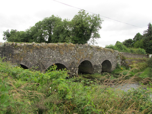
Four-arch rubble stone hump backed bridge, built c.1740, over water channel flowing south. North face rebuilt c.1800 using cut stone elements. Rubble stone abutments with V-cutwaters with splayed rendered tops to both elevations. Segmental arches with rubble-stone soffits having roughly-hewn irregular voussoirs and cutwaters to south face, cut stone arch ring of regular even voussoirs to north face, with higher arches to two north spans. Coursed rubble stone walls to spandrels and parapet on north face, Scotch coping to parapets. Square ends to south wing walls, recent concrete block to north-east wing wall with stepped stone retaining wall below, battered rubble stone retaining wall to north-west.
An eighteenth century bridge of rubble stone construction, with the south elevation reconstructed at a later date using cut-stone elements, resulting in an informal combination of arch sizes and a fascinating mix of construction techniques. It retains fabric from both stages of construction and demonstrates the evolution of bridge building technology employed in Grand Jury road projects over the course of the eighteenth century. The bridge is an interesting addition to the county's civil engineering heritage.
From the Buildings of Ireland (National Inventory of Architectural Heritage) record 40403310
This does not grant access. Most recorded buildings are privately owned; view them only from public ground unless the owner allows entry.
Places near here
Beagh GlebeMountain / peak · 895 yd Killinkere Church of Ireland ChurchChurch/chapel · 1160 ydrectory/glebe/vicarage/curate's house1549 ydBirthplace of General Philip SheridanMemorial · 1.1 miCarraig-na-SasanacNamed rock · 1.5 miWindmill in Enagh (crossbane Ed)Windmill · 2.3 miEnaghMountain / peak · 2.3 miGrave YardGraveyard · 2.9 miEuropean Yew3.6 miWelcome to VirginiaVisitor information · 3.8 miSessile Oak4.1 miBrothers GravesVisitor information · 4.3 mi
 Killinkere Church of Ireland ChurchChurch/chapel · 1160 yd
 rectory/glebe/vicarage/curate's house1549 ydBirthplace of General Philip SheridanMemorial · 1.1 miCarraig-na-SasanacNamed rock · 1.5 mi
 Windmill in Enagh (crossbane Ed)Windmill · 2.3 mi
 EnaghMountain / peak · 2.3 mi
 Grave YardGraveyard · 2.9 mi
 European Yew3.6 mi
 Welcome to VirginiaVisitor information · 3.8 mi
 Sessile Oak4.1 mi
 Brothers GravesVisitor information · 4.3 mi
Pictures: Christopher Kirk, Geograph · Creative Commons Attribution-ShareAlike 2.0; National Inventory of Architectural Heritage; Kieran Campbell, Geograph · CC BY-SA 2.0; Kieran Campbell, Geograph · Creative Commons Attribution-ShareAlike 2.0; Sitomon, Wikimedia Commons · CC BY-SA 2.0; P Webb, Geograph · CC BY-SA 2.0; Maker named on the Wikimedia Commons picture page · CC BY-SA 2.5; Oliver Dixon, Geograph · CC BY-SA 2.0
More historic places in County Cavan · All of County Cavan
What do you know about this place?