What is recorded here
Internal diam. c. 15m. A subcircular area now enclosed by a modern wall apparently built on the line of a collapsed cashel wall parts of which can still be seen. The site is located on a height in fairly good land. An old roadway 2.35m wide bounded on each side by an earthen bank and fosse is evident just NNE of the…
Read the whole record
From the National Monuments Service (Archaeological Survey of Ireland) record DG098-016
Places near here
Photo credits
- National Inventory of Architectural Heritage
- Kenneth Allen, Wikimedia Commons · CC BY-SA 2.0
- EecherplazGinkgo06.jpg : Cayambe derivative work: Ginkgotree ( talk ), Wikimedia Commons · CC BY-SA 3.0
- Ronnie Nijboer, Wikimedia Commons · CC0
- C Michael Hogan, Wikimedia Commons · CC BY-SA 2.0
- David Dixon, Wikimedia Commons · CC BY-SA 2.0
- louise price, Geograph · CC BY-SA 2.0
- louise price, Wikimedia Commons · CC BY-SA 2.0
- Andreas F. Borchert, Wikimedia Commons · CC BY-SA 4.0
- Kenneth Allen, Geograph · CC BY-SA 2.0
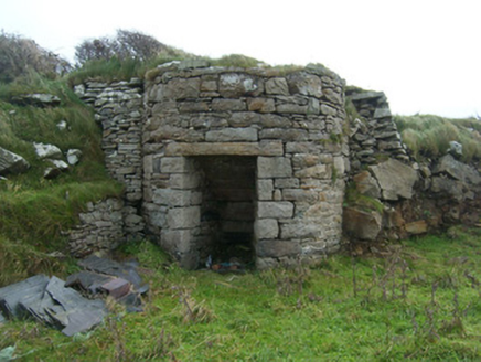 kiln256 yd
Explorer Tom Kiln in Rahan Near is a round lime kiln from the 1800s that really knows how to bake. Most are square, but this one chose to be cool and circular. Stick your head out the window and give it a cheeky salute!
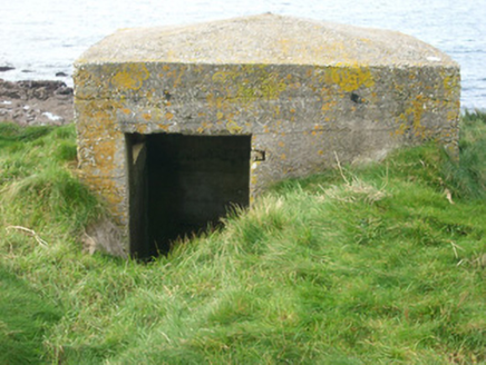 watch tower, pill box571 yd
Explorer Tom Watch tower, Pill box in Rahan Near looks like a concrete egg that forgot to harden. Built around 1940, its flimsy walls would barely stop a sneeze, let alone a cannonball. I imagine the sentries inside were more worried about damp socks than enemy fire.
 Killaghtee Old Church GraveyardGraveyard · 623 yd
Explorer Tom Killaghtee Old Church Graveyard sits beside the old church; inside the graveyard, southwest of that church, the survey records a cross-inscribed slab. The Civil Survey called the church 'in reparation', and it remained in use until 1826. I like how one small mapped area holds separate records for the graveyard, church and stone.
 Ginkgo1461 yd
Explorer Tom Ginkgo in County Donegal is basically a dinosaur wearing a leafy coat, surviving things that would kill other trees instantly. It’s exotic, weird, and definitely not what you’d expect to find in Donegal. Pack a picnic and an excuse for why you’re talking to a tree so loudly.
 Wych Elm1.1 mi
Explorer Tom Wych Elm four in County Donegal is just standing there looking confused about why you need permission to see a tree. It's probably thinking about the past. Ask it if it remembers when elms were cool again.
 Cashel Town Wedge TombsWedge tomb · 1.7 mi
Explorer Tom Cashel Town Wedge Tombs are unique because three galleries sit side-by-side in a single circular kerb. One roofstone is four metres long, and locals once found giant human bones here, which is either brilliant or terrifying.
 Rashenny PointHeadland · 2.4 mi
Explorer Tom Rashenny Point thinks its secret talent is competitive napping, and honestly? It’s good at it. The headland is just vibing out there in the sun. Take the long way round, because this spot deserves the extra effort and scenic drive.
 Carntullagh HeadHeadland · 2.5 mi
Explorer Tom Carntullagh Head is a rugged County Donegal point that apparently doubles as a fish farm. I imagine the wild seabirds looking down at their new plastic neighbours with mild confusion, wondering if this is still the natural order of things.
 Rotten IslandIslet · 2.6 mi
Explorer Tom Rotten Island sounds like a pirate's insult, but its lighthouse story is serious. The light guides boats into Killybegs Harbour; three workers drowned returning from the island while it was being built. I would remember them whenever that white tower comes into view.
 Cat CastleCastle, tower house · 2.7 mi
Explorer Tom Cat Castle is named after St. Catherine, but really it’s just a tiny stone corner standing on a hill above Killybegs Harbour. It’s been shrinking since 1355, and now only a 3-metre wall survives. It’s a bit pathetic, sure, but looking out over the harbour makes you wonder what that bishop’s manor looked like when it was whole.
 St Catherine's WellHoly well · 2.7 mi
Explorer Tom St Catherine's Well in Killybegs was once a famous pilgrimage site, but there’s a daft legend that a Protestant rector tried to fill it up with dirt. The next day, a spring burst into his drawing room, terrifying his wife until he reopened the well. It’s still cleaned for St. Catherine’s Day, sitting beside the ruins of 'Cat Castle' in marshy pasture.
 Tara HotelHotel · 2.8 mi
Explorer Tom Tara Hotel in Killybegs is probably where some forgotten hero saved it from a tidal wave nobody else remembers. The Wi-Fi might be slow, but the stories fly faster than a gull on Main Street. Walk past slowly like you're in a film.
More archaeology and monuments in County Donegal · All of County Donegal

What do you know about this place?Tap to add a comment or ask a question