What is recorded here
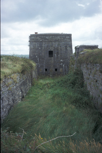
Freestanding six-bay single-storey over basement fort, built c. 1810, surrounded by moat. Now disused. Inclined cut-limestone parapet with brick chimneystack to roof. Cut-limestone walls with base batter. Timber matchboard door set in segmental-arched recess to accommodate retractable drawbridge. Gun loops and square-headed windows with cut-stone dressings. Detached four-bay single-storey magazine with moat and base batter to site. Snecked stone retaining walls to glacis extending to shore. Cut-stone gate piers set in rubble stone walls.
From the Buildings of Ireland (National Inventory of Architectural Heritage) record 20406805
This does not grant access. Most recorded buildings are privately owned; view them only from public ground unless the owner allows entry.
Places near here
Photo credits
- Charles W Glynn, Wikimedia Commons · CC BY-SA 2.0
- P L Chadwick, Wikimedia Commons · CC BY-SA 2.0
- National Inventory of Architectural Heritage
- Garry Dickinson, Wikimedia Commons · CC BY-SA 2.0
- Graham Horn, Geograph · Creative Commons Attribution-ShareAlike 2.0
- Tiger, Geograph · CC BY-SA 2.0
- Graham Horn, Geograph · CC BY-SA 2.0
Labasheeda Fort (19th Century)Castle · 24 yd Tarbert LighthouseLighthouse · 1.2 miClonderalaw BayBay · 1.6 miHachured, Massys HillBastioned fort · 1.7 miOaklandsHouse · 1.9 miCrag WoodWood · 2.6 miGlin CastleCastle · 2.7 miMountshannon WoodWood · 2.8 miGrave YardGraveyard · 2.9 miSt Senan's WellSpring · 3.7 miLabasheeda BayBay · 3.8 miLabasheeda QuayVisitor information · 4.1 mi
 Tarbert LighthouseLighthouse · 1.2 mi
 Clonderalaw BayBay · 1.6 miHachured, Massys HillBastioned fort · 1.7 mi
 OaklandsHouse · 1.9 miCrag WoodWood · 2.6 mi
 Glin CastleCastle · 2.7 miMountshannon WoodWood · 2.8 mi
 Grave YardGraveyard · 2.9 mi
 St Senan's WellSpring · 3.7 mi
 Labasheeda BayBay · 3.8 mi
 Labasheeda QuayVisitor information · 4.1 mi
More historic places in County Clare · All of County Clare
What do you know about this place?