
What is recorded here
Kennacoil is a field system in Perth and Kinross, Scotland.
From the Historic Environment Scotland record 87256
The historic-place record does not grant public access. Check current conditions and ownership before entering land or a building.
Places near here
Photo credits
- Karl Peet, Wikimedia Commons · CC BY-SA 2.0
- Stanley Howe, Wikimedia Commons · CC BY-SA 2.0
- Jim Barton, Wikimedia Commons · CC BY-SA 2.0
- Lis Burke, Wikimedia Commons · CC BY-SA 2.0
- Deirdre O'Neill, Wikimedia Commons · CC BY-SA 2.0
- Russel Wills, Wikimedia Commons · CC BY-SA 2.0
- Gordon Hatton, Wikimedia Commons · CC BY-SA 2.0
- Scott Cormie, Wikimedia Commons · CC BY-SA 2.0
- Rob Burke, Wikimedia Commons · CC BY-SA 2.0
- Doug Lee, Wikimedia Commons · CC BY-SA 2.0
 Falls of the BraanWaterfall · 343 yd
 Rumbling BridgeRoad Bridge · 348 yd
 LagganallachieBurial Ground (medieval), Church (medieval) (possible), Church (19th Century), Gravestone(s) (18th Century) · 672 yd
 TarfuackBuilding(s) (19th Century), Enclosure (19th Century) · 848 yd
 Meikle LogieTownship · 1004 yd
 Dunkeld, the Hermitage, Ossian's CaveFolly (18th Century) · 1115 yd
 Pine Cone PointViewpoint · 1346 yd
 Falls of BraanWaterfall · 1459 yd
 Ossian's HallVisitor information · 1527 yd
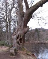 Niel Gow's OakOak · 1.3 mi
 Torchuaig HillMountain / peak · 1.3 mi
 Polney CragCliff · 1.4 mi
More archaeology and monuments in Perth and Kinross · All of Perth and Kinross
What do you know about this place?