What is recorded here
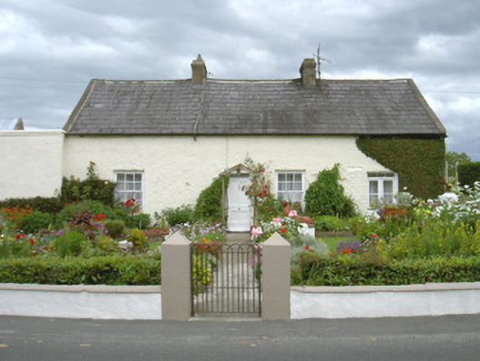
Ivy Cottage in Drummullagh keeps its nine-pane attic windows round the back. From the front, it's a modest little cottage minding its own business; behind, it's opened nine separate enquiries into what's happening in the garden.
Detached four-bay single-storey with attic house, built c. 1830. Return with lean-to corrugated asbestos roof to rear (north), range of single-storey outbuildings to west with single-pitch profiled metal roof. Pitched slate roof, clay ridge tiles, tiled verges, unpainted smooth rendered corbelled chimneystacks, half-round uPVC gutters on eaves corbel course. Painted roughcast rendered walling. Square-headed window openings, painted stone sills, painted smooth rendered reveals, painted timber six-over-six sliding sash windows to front elevation, six-over-three to rear elevation, casement windows in return and to gable, nine-pane inward-opening casements to attic north elevation. Square-headed door opening; painted timber four-panel entrance door with carved moulding to framing, bipartite plain glazed overlight; painted timber double doors with tripartite overlight to east end of front elevation, lower panels vertically-sheeted, upper panels glazed and horizontally sub-divided. Set in own grounds with outbuildings to north and west, landscaped front garden to south, central concrete path leading from hooped wrought-iron pedestrian gate at roadside, painted rendered low-level boundary wall.
This appealing house is considerably enhanced by its garden. original timber sliding sash windows survive and the carved detailing on the entrance door adds additional interest. Multi-pane casement windows on the rear elevation at attic level are of particular interest.
From the Buildings of Ireland (National Inventory of Architectural Heritage) record 13833001
This does not grant access. Most recorded buildings are privately owned; view them only from public ground unless the owner allows entry.
Places near here
Photo credits
- Eric Jones, Geograph · Creative Commons Attribution-ShareAlike 2.0
- National Inventory of Architectural Heritage
- Eric Jones, Geograph · CC BY-SA 2.0
- Wilson Adams, Wikimedia Commons · CC BY-SA 2.0
- HENRY CLARK, Wikimedia Commons · CC BY-SA 2.0
- James O'Neill, Wikimedia Commons · CC BY-SA 4.0
 WoodvaleHouse · 150 yd
 Saint Andrew's Church (Carlingford)School · 262 yd
 Joanne ReillyMemorial · 1182 yd
 Narrow Water KeepHeritage attraction · 1.2 mi
 Warrenpoint ambushAmbush · 1.2 mi
 Narrow Water WatchtowerVisitor information · 1.2 mi
 Tower-house and bawn: narrow water castle in Narrow WaterTower-house and Bawn: Narrow Water Castle · 1.2 mi
 Carlingford Lough GreenwayWalking route · 1.3 mi
 Narrow Water CastleCastle · 1.5 mi
 Dobbin's PointHeadland · 1.5 mi
 Anglesey MountainMountain / peak · 1.7 mi
 Clermont Carn ne TopMountain / peak · 2.0 mi
More historic places in County Louth · All of County Louth
What do you know about this place?