
What is recorded here
From OpenStreetMap (© OpenStreetMap contributors) n6417127511
Places near here
Photo credits
- Maker not stated on source page, en.wikipedia.org
- Maker not stated on source page, www.traverse-blog.com
- Maker not stated on source page, commons.wikimedia.org
- The Banner, Wikimedia Commons · CC BY-SA 4.0
- Maker not stated on source page, en.m.wikipedia.org
- Maker not stated on source page, storage.googleapis.com
- Roger Diel, Wikimedia Commons · CC BY-SA 2.0
- Maker not stated on source page, www.tripadvisor.in
- National Inventory of Architectural Heritage
- Colin Park, Geograph · CC BY-SA 2.0
- N Chadwick, Geograph · CC BY-SA 2.0
- Maker not stated on source page, www.dreamstime.com
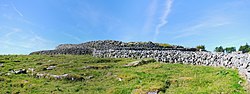 Fairy fort / earthen ringfort in BallynacarhaghFairy fort / earthen ringfort · 890 yd
Explorer Tom Fairy fort / earthen ringfort in Ballynacarhagh sits on a ridge like it owns the place, which is rich for a dirt…
 Cullagh CastleRuins · 1233 yd
Explorer Tom Cullagh Castle would survive a zombie attack because they’d get stuck in the rubble trying to climb in. It’s a ruin…
 Fairy fort / earthen ringfort in BallybaunFairy fort / earthen ringfort · 1543 yd
Explorer Tom Fairy fort / earthen ringfort in Ballybaun took forty-seven cups of tea to build, all cold by the time they finished…
 Saint Attracta's Catholic ChurchChurch/chapel · 1731 yd
Explorer Tom Saint Attracta's Church is a double-height building that probably echoes your every whisper back at you with judgment.…
 Enclosure in BallybaunEnclosure · 1.1 mi
Explorer Tom Enclosure in Ballybaun is hiding a scandal involving a very angry cow and a misplaced fence post from centuries ago.…
 Fairy fort / stone ringfort in BallybaunFairy fort / stone ringfort · 1.2 mi
Explorer Tom Fairy fort / stone ringfort in Ballybaun is poorly preserved and grass-covered, looking like it gave up halfway.…
 Caherminnaun Castle (in ruins)Castle, unclassified · 1.4 mi
Explorer Tom Caherminnaun Castle is basically a heap of rubbish that thinks it's a monument. O’Curry said it was 'a heap of ruins'…
 Fairy fort / stone ringfort in MaryvilleFairy fort / stone ringfort · 1.5 mi
Explorer Tom Fairy fort / stone ringfort in Maryville is officially 'no longer visible' but we’re gonna pretend it’s just being…
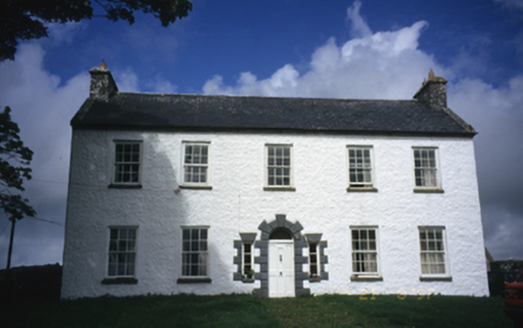 Hollywell HouseFarm house · 1.7 mi
Explorer Tom Hollywell House in Maryville, County Clare, had its top floor chopped off around 1910 because it got too tall for its…
 Burren Centre KilfenoraVisitor information · 1.8 mi
Explorer Tom The Burren Centre in Kilfenora is a sensible first stop before trying to make sense of north Clare's limestone hills. I…
 High CrossHeritage attraction · 1.9 mi
Explorer Tom This High Cross had a moment where a fox took charge of the whole site, sitting on top of it looking like a tiny…
 Graveyard in KilcarraghGraveyard · 2.1 mi
Explorer Tom Graveyard in Kilcarragh only has one stone, so if you drop your phone there, that’s officially it for the whole place.…
More mountains and hills in County Clare · All of County Clare

What do you know about this place?Tap to add a comment or ask a question