What is recorded here
Invermill is an ancient site in Perth and Kinross, Scotland.
From OpenStreetMap (© OpenStreetMap contributors) n2626961069
This does not grant access. Check current paths, opening conditions and ownership before entering.
Places near here
Photo credits
- Gordon Hatton, Wikimedia Commons · CC BY-SA 2.0
- Andreas Wilhelm, Wikimedia Commons · CC BY-SA 2.0
- ronnie leask, Wikimedia Commons · CC BY-SA 2.0
- Trevor Littlewood, Wikimedia Commons · CC BY-SA 2.0
- Scott Cormie, Wikimedia Commons · CC BY-SA 2.0
- Sciadopitys from UK, Wikimedia Commons · CC BY-SA 2.0
- Eirian Evans, Wikimedia Commons · CC BY-SA 2.0
- Mrs W J Sutherland, Wikimedia Commons · CC BY-SA 2.0
- Richard Simkin, Wikimedia Commons · Public domain
- Andrew Abbott, Wikimedia Commons · CC BY-SA 2.0
 InverPestle (stone) · 107 yd
 InverVillage · 147 yd
 Inver BridgeRoad Bridge (18th Century) · 197 yd
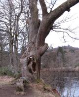 Niel Gow's OakOak · 403 yd
 DunkeldPin (bronze) · 442 yd
 Ossian's HallVisitor information · 874 yd
 Falls of BraanWaterfall · 940 yd
 Parent LarchEuropean Larch · 944 yd
.jpg/250px-The_Gates_to_Dunkeld_Cathedral_(geograph_7434499).jpg "Photo: Eirian Evans, Wikimedia Commons · CC BY-SA 2.0") Cathedral GatesMemorial · 1075 yd
Cathedral GatesMemorial · 1075 yd The Old RectoryMemorial · 1088 yd
 Battle of DunkeldMajor battlefield · 1106 yd
.jpg/250px-Cathedral_Street,_Dunkeld_(geograph_6570100).jpg "Photo: Andrew Abbott, Wikimedia Commons · CC BY-SA 2.0") Cathedral Street, DunkeldNo Class (event) · 1113 yd
Cathedral Street, DunkeldNo Class (event) · 1113 ydMore archaeology and monuments in Perth and Kinross · All of Perth and Kinross
What do you know about this place?