
What is recorded here
A short but steep section at the north end may be challenging. Otherwise a great combination of riverside and forest.
Places near here
Picture notes
- John Allan, Wikimedia Commons · CC BY-SA 2.0
- Donald Watson, Wikimedia Commons · CC BY-SA 2.0
- Computer-made picture. It does not show this holy well.
- Raymond Chisholm, Wikimedia Commons · CC BY-SA 2.0
- Computer-made picture. It does not show this cliff.
- Computer-made picture. It does not show this walking route.
- Gordon Hatton, Wikimedia Commons · CC BY-SA 2.0
- Russel Wills, Wikimedia Commons · CC BY-SA 2.0
- Scott Cormie, Wikimedia Commons · CC BY-SA 2.0
 Dunkeld, Dunkeld House, West GrottoGrotto (garden) (post Medieval) · 136 yd
 King's SeatFort (early Medieval), Hearth(s) (early Medieval) (550)-(645), Crucible(s) (early Medieval), Crucible(s) (early Medieval), Mould(s) (stone)(early Medieval) · 277 yd
 St Colme's WellHoly Well (medieval) · 319 ydComputer-made picture
 Dunkeld, Dunkeld HouseCountry House (20th Century), Hotel (20th Century) · 327 yd
 Ivy ButtressCliff · 385 ydComputer-made picture
 Myopics ButtressCliff · 401 ydComputer-made picture
 Dalguise to DunkeldWalking route · 619 ydComputer-made picture
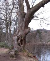 Niel Gow's OakOak · 703 yd
 Pine Cone PointViewpoint · 777 yd
 Torryvald RouteWalking route · 779 ydComputer-made picture
 Ossian's HallVisitor information · 1105 yd
 Falls of BraanWaterfall · 1118 yd
More walking routes in Perth and Kinross · All of Perth and Kinross

What do you know about this place?Tap to add a comment or ask a question