What is recorded here
From OpenStreetMap (© OpenStreetMap contributors) w467306886
Places near here
Photo credits
- National Inventory of Architectural Heritage
- Kenneth Allen, Geograph · CC BY-SA 2.0
- David Dixon, Geograph · CC BY-SA 2.0
- Ronnie Nijboer, Wikimedia Commons · CC0
- louise price, Wikimedia Commons · CC BY-SA 2.0
- Andreas F. Borchert, Wikimedia Commons · CC BY-SA 4.0
- Becky McReynolds, Wikimedia Commons · CC BY-SA 4.0
- N Chadwick, Geograph · CC BY-SA 2.0
- Stephan van Helden, Wikimedia Commons · CC BY-SA 4.0
- Ian S, Geograph · CC BY-SA 2.0
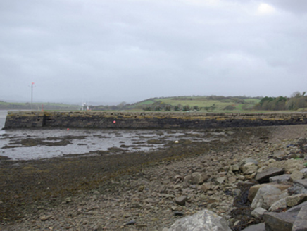 Mullansole PierPier/jetty · 471 yd
Explorer Tom Mullansole Pier has a wrought-iron anchor on its deck and iron rings for mooring ropes. A local account says John Hamilton built it around 1840 to carry grain and flour from his mill. I picture one bag demanding a window seat on the trip down Donegal Bay.
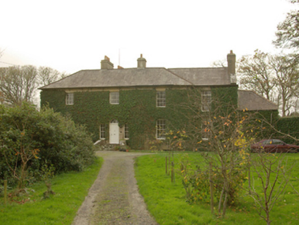 Murvagh HouseHouse · 984 yd
Explorer Tom Originally a Church of Ireland rectory from c. 1792, this L-shaped house in Drumbristan Glebe has evolved with dormer attics and returns into a substantial private home.
 MurvaghOfficial bathing water · 1.1 mi
Explorer Tom Murvagh Beach has a wartime lookout hut that Joy Browne, writing for Donegal tourism, remembers playing in as a child. She says erosion has since sunk it into the sand and made entry impossible. A lookout hut retiring by burying its feet is theatrical enough for me; I would leave it to its rest.
 Rooney's IslandIslet · 1.1 mi
Explorer Tom Rooney's Island was once home to the O'Maoldory Clan, who ruled as Kings of Tir Conaill. I imagine a very serious coronation ceremony taking place on a patch of ground that barely fits a picnic blanket.
 Ballyboyle IslandIslet · 2.1 mi
Explorer Tom Ballyboyle Island takes its name from the O’Boyle clan, sub-chieftains of the O’Donnells who once ruled from Donegal Castle.
 Wych Elm2.6 mi
Explorer Tom Another Wych Elm in County Donegal, probably just as sturdy and silent, keeping secrets in its twisted branches.
 Killymard Old Church GraveyardGraveyard · 2.9 mi
Explorer Tom Killymard Old Church Graveyard encloses a church whose story changes after a bleak 1622 report: it was ruinous then, was later repaired or rebuilt, and remained in use until a new church opened at Ballydevitt in 1829. The earliest modern grave slab noted in the account dates to 1809. Two timelines fit inside one walled place.
 Siege of DonegalSiege · 3.0 mi
Explorer Tom During the 1601 Siege of Donegal, an accidental gunpowder blast destroyed the town's abbey amid weeks of fighting. The abbey was no castle wall, but war managed to reach it all the same.
 Donegal Friary GraveyardGraveyard · 3.1 mi
Explorer Tom Donegal Friary Graveyard sits amid a place whose history changed violently in 1601, when an explosion and fire damaged the friary during a siege. The survey says later burial use raised the ground by as much as 1.75 metres. I had to read that twice: the height records generations of burial, not a building foundation.
 Salthill CabinCafé · 3.1 mi
Explorer Tom Salthill Cabin is likely just a shed with a coffee machine and delusions of grandeur. It’s in County Donegal, so expect rain to pour straight through the roof. Take a photo if you find any actual salt anywhere.
 Horse-chestnut3.2 mi
Explorer Tom A striking Horse-chestnut stands proud in Donegal, and you might need permission to view it properly.
 The HarbourRestaurant · 3.3 mi
Explorer Tom The Harbour in Donegal sits right on Quay Street, perfect for watching boats. Take a photo of the water for me, I’m already seasick from the breeze!
More islands in County Donegal · All of County Donegal

What do you know about this place?Tap to add a comment or ask a question