
Places near here
Photo credits
- National Inventory of Architectural Heritage
- Geograph contributor · CC BY-SA 2.0
- Mike Searle, Wikimedia Commons · CC BY-SA 2.0
- Christian Pirkl, Wikimedia Commons · CC BY-SA 3.0 at
- Sitomon, Wikimedia Commons · CC BY-SA 2.0
- Nigel Thompson, Wikimedia Commons · CC BY-SA 2.0
- Hugh Thomson, Wikimedia Commons · Public domain
- The original uploader was Dppowell at English Wikipedia ., Wikimedia Commons · CC BY-SA 2.5
- Rick Crowley, Wikimedia Commons · CC BY-SA 2.0
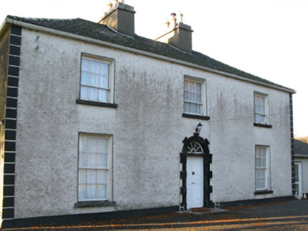 Fort VilleFarm house · 1157 yd
Explorer Tom Fort Ville in Ellistronbeg has an escape plan for its first owner that involves running straight into the low-lying landscape. It’s a Georgian farmhouse with a radial fanlight that looks like it’s smiling at your mistakes. If anyone asks, Tom says it’s the most fortified potato barn he’s ever seen.
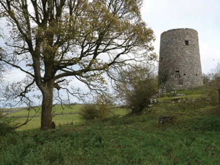 Highwood MillMill (wind) · 1.2 mi
Explorer Tom Highwood Mill in Ardkill is a windmill that forgot how to spin. It nearly became famous when a local claimed it hummed Beethoven, which made me laugh until I cried. Snap one photo, then put your phone away before you drop it in the mud.
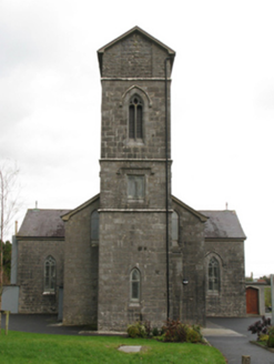 Saint Patrick's Catholic ChurchChurch/chapel · 1.4 mi
Explorer Tom Saint Patrick's Catholic Church in Frenchbrook North smells like old paper and regret, according to Tom. The sparrow-pecked stone looks like it’s been chewing on something crunchy for centuries. Bring a friend who loves damp, gothic mysteries.
 Killernan CastleCastle · 1.5 mi
 Cloonagashel CastleCastle · 3.4 mi
 Sycamore3.5 mi
Explorer Tom Sycamore’s least favourite visitor is definitely the guy who tries to climb it in his dress shoes and complains about the leaves. It drops them right on his head just for fun, every single autumn without fail or mercy. It's the kind of place that makes a dull Tuesday interesting.
 European Yew3.7 mi
Explorer Tom European Yew remembers the priest who lost a bet there and had to walk the whole way back home barefoot. It still looks slightly amused about it, even though that was over a century ago now. Ideal spot for a dramatic phone call.
 The Gods of the Neale MonumentMonument · 3.9 mi
 Neale CemeteryCemetery · 4.1 mi
 Ballymacgibbon CairnArchaeological place · 5.7 mi
 Ross Errilly FriaryHeritage attraction · 8.3 mi
Explorer Tom Call Ross Errilly an abbey and somebody in Galway may forgive you, but the friars would ask where you found their abbot. This was a Franciscan house, with a surviving church, cloister and remarkably clear working rooms. Find the kitchen: it had an oven and a tank for keeping fish alive. I can barely keep a loaf from burning, so fair play to their planning. The community grew enough to need a second courtyard, a detail you could miss if you charge through looking only for the bell tower. Ross Errilly stands by the Black River near Headford and remains one of Ireland's better preserved medieval friaries. Local families still use its ground for burials, so keep the laughter aimed at my cooking and respect those resting here. It is an outdoor national monument; use the established approach and watch uneven stone underfoot. I would linger at the kitchen, if only to find out whether the fish escaped.
 Inis an GhaillIsland · 11 mi
Explorer Tom Inis an Ghaill has a small stone that can stop a boastful guide in mid-sentence. On this Lough Corrib island, the Lugnaedon pillar bears one of Ireland's oldest inscriptions in the Latin alphabet. Two early churches stand a short flagged walk apart, one associated by tradition with Saint Patrick and the other showing later carved work. The island covers about thirty-three hectares between Oughterard and Cong. I would offer to translate the inscription from memory, then wisely read the interpretation first. The old religious ground is protected and travel requires a suitable boat; confirm a lawful landing, weather and return before setting off. Leave the carved stone and church walls untouched. Look at the short path between the buildings. Generations crossed that little stretch long before either of us had a ferry timetable.
More archaeology and monuments in County Mayo · All of County Mayo

What do you know about this place?Tap to add a comment or ask a question