Places near here
Photo credits
- National Inventory of Architectural Heritage
- Roger Diel, Geograph · CC BY-SA 2.0
- Simon Huguet, Wikimedia Commons · CC BY-SA 2.0
- GenesisNZ, Wikimedia Commons · CC BY-SA 4.0
- Chris, Geograph · CC BY-SA 2.0
- Richard cattel, Geograph · CC BY-SA 2.0
- Eddylandzaat, Wikimedia Commons · CC BY 3.0
- Gordon Hatton, Geograph · CC BY-SA 2.0
- Charles W Glynn, Geograph · CC BY-SA 2.0
- Charles W Glynn, Wikimedia Commons · CC BY-SA 2.0
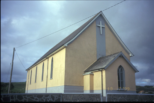 Catholic Church of the Most Holy RedeemerChurch/chapel · 1.8 mi
Explorer Tom Catholic Church of the Most Holy Redeemer in Coor West is keeping secrets after 1865. Ask it about the 1978 renovation and watch it blush red! Bring your worst joke, the place has heard worse.
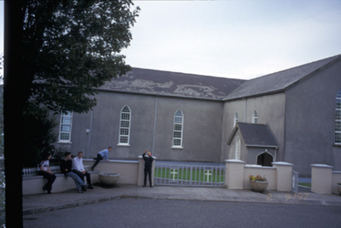 Saint Mary's Roman Catholic ChurchChurch/chapel · 2.6 mi
Explorer Tom Saint Mary's Roman Catholic Church in Finnor More is an 1844 T-plan church with gabled porches that look like they’re judging you. It’s got replacement uPVC windows, which is a bit of a letdown for such a historic date. Take a mate and argue about what it was for.
 Tromra CastleCastle, tower house · 4.9 mi
Explorer Tom Tromra Castle overlooks Mutton Island from level marshy ground, which sounds like a bad dream. The wind probably picked on it because it stood too still for forty years. Look up, the best bit is always higher than you think, unless you fall in.
 Emlagh PointHeadland · 5.0 mi
Explorer Tom Emlagh Point would take its lotto win, buy a massive pair of binoculars, and just stare at the bay until the fish get nervous and start paying rent. It’s got that 'I know things' vibe without actually knowing anything specific about the tides or the weather patterns. Look serious, nod slowly, you're basically an expert now.
 Spanish Point BeachBeach / strand · 5.0 mi
Explorer Tom Spanish Point Beach was clearly designed by a mother-in-law who hates dogs and thinks horses take up too much room at the dinner table. It’s got strict rules about who gets to use its sands, acting like the whole coast is its personal living room. Go with someone who loves old stuff and watch them melt.
 Spanish PointVisitor information · 5.3 mi
Explorer Tom Sightseeing Cliffs of Moher South has a real opinion on tourists from Dublin, thinking they’re all a bit too eager to snap photos and not quite enough in awe of how huge this place actually is. It’s got that cheeky swagger, always leaning into the wind like it’s showing off its best features for the camera. Perfect detour when the satnav has a meltdown, because honestly, who trusts
 Caherrush Castle (in Ruins)Castle, tower house · 5.4 mi
Explorer Tom Caherrush Castle is probably being run by a fox who thinks he’s the landlord. It’s a tower house that’s seen better days and worse tenants. Pick a stone, any stone, and invent its biography as a famous pirate.
 Seafield North BeachBeach / strand · 5.5 mi
Explorer Tom Seafield North Beach inspired someone to write such a terrible poem about it that the harbour itself is still embarrassed to be seen in the same photo. Mutton Island looks on in pity, wondering why everyone thinks a bad rhyme makes for good travel advice. Find the wonkiest bit and send it to your group chat.
 SlievecallanMountain / peak · 5.6 mi
Explorer Tom Slievecallan is hiding its light under a bushel of winter frost, pretending it doesn't matter that nobody remembers the hero who supposedly saved it from being turned into a shopping mall. It’s all very dramatic, really, like a soap opera where the main character has forgotten their lines and just stands there looking chilly. Toast it with a cup of tea and move on to the next.
 Lurga PointHeadland · 5.9 mi
Explorer Tom Lurga Point is getting picked on by the wind because it stands so close to Mutton Island, which makes it look like a very confused bodyguard trying to protect a tiny sheep from the ocean’s wrath. It’s exhausted from the constant buffeting and just wants some quiet time without being shouted at by every single gust that comes along for the ride. Visit, then text me what you think. I'll pretend to读它
 Doughmore BeachBeach / strand · 6.0 mi
Explorer Tom Doughmore Beach is that fiddler who played all night but somehow convinced everyone the sand was shifting just for his benefit. Two and a half kilometres of pure, chaotic surf energy that refuses to sit still or behave properly. Bring a notebook and write the bit I made up.
 Mutton IslandIsland · 7.1 mi
Explorer Tom Mutton Island off Clare really does have sheep, so I cannot even claim the name is one of my inventions. The island lies about 1.5 kilometres from shore near Quilty. Two old forts and roofless houses recall different periods of use, while people still lived here into the 1920s. I would offer to walk over at low tide, but there is a sea crossing and no jetty to make my boast remotely sensible. Sheep graze the ground today, and there is no regular public ferry. View it from a lawful mainland point unless you have a permitted boat and safe landing arranged with people who know the water. Leave old structures and grazing animals alone. The quiet outline is a poor measure of how much human work went into living on it.
More archaeology and monuments in County Clare · All of County Clare

What do you know about this place?Tap to add a comment or ask a question