
What is recorded here
From the National Monuments Service (Archaeological Survey of Ireland) record TN019-055
Places near here
Photo credits
- Maker not stated on source page, nl.pinterest.com
- P L Chadwick, Geograph · CC BY-SA 2.0
- JP, Geograph · CC BY-SA 2.0
- Maker not stated on source page, ca.pinterest.com
- David P Howard, Wikimedia Commons · CC BY-SA 2.0
- Maker not stated on source page, www.flickr.com
- National Inventory of Architectural Heritage
- Maker not stated on source page, commons.wikimedia.org
- Dylan Moore, Wikimedia Commons · CC BY-SA 2.0
- Kmcnamee, Wikimedia Commons · CC BY-SA 4.0
- Willow, Wikimedia Commons · CC BY 2.5
- Maker not stated on source page, en.m.wikipedia.org
 Townlough Castle (in ruins)Castle, tower house · 233 yd
Explorer Tom Townlough Castle bragged about surviving a storm that probably just missed it by a mile. Only one corner is left, and…
 Laghtea HillMountain / peak · 1442 yd
Explorer Tom Laghtea Hill has an imaginary twin across the sea that it talks to every night using Morse code via lightning strikes.…
 Crow IslandIslet · 1649 yd
Explorer Tom Crow Island in County Clare hosted a fiddler who played all night until his fingers turned into crows and flew away.…
 Goose IslandsIslet · 1724 yd
Explorer Tom Goose Islands in County Clare are protected by a superstition that says if you whistle, they’ll all fly away and leave…
 Graves of the LeinstermenArchaeological place · 1.2 mi
Explorer Tom Graves of the Leinstermen are being guarded by a very serious terrier who thinks he is the actual king of Tipperary…
 Derry CastleBawn · 1.5 mi
Explorer Tom The bawn at Derry Castle in Derry Demesne has strong opinions about the road leading to it, mostly because it’s blocked…
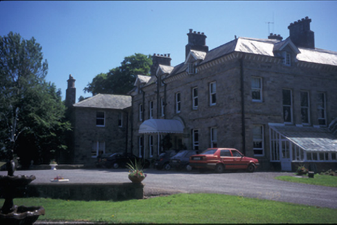 Tinarana HouseCountry house · 1.5 mi
Explorer Tom Tinarana House in Islandcosgry is an 1860 country house built by the Purdons, who probably thought they were gods.…
 Castletown CemeteryCemetery · 1.5 mi
Explorer Tom Castletown Cemetery in County Tipperary is bragging it survived a storm that flattened everything else, which is bold…
 Church (in Ruins), GraveyardChurch · 1.5 mi
Explorer Tom Church, Graveyard in Castletown is feeling a bit left out. It’s sitting right next to Lough Derg, which I reckon is its…
 Ogonnelloe GAA pitchGAA ground · 1.9 mi
 European ash1.9 mi
Explorer Tom European ash in County Clare had a New Year’s resolution to grow one more leaf per year, but it’s been stuck at zero…
 Enclosure in BallyhurlyEnclosure · 2.4 mi
Explorer Tom Enclosure in Ballyhurly handles nosey neighbours by just standing there, looking vaguely disappointed at their lack of…
More archaeology and monuments in County Tipperary · All of County Tipperary

What do you know about this place?Tap to add a comment or ask a question