
Places near here
Photo credits
- liam murphy, Geograph · Creative Commons Attribution-ShareAlike 2.0
- National Inventory of Architectural Heritage
- Algirdas at Lithuanian Wikipedia, Wikimedia Commons · Public domain
- Sciadopitys from UK, Wikimedia Commons · CC BY-SA 2.0
- liam murphy, Wikimedia Commons · CC BY-SA 2.0
- 瑞丽江的河水, Wikimedia Commons · CC BY-SA 4.0
- Darrin Antrobus, Wikimedia Commons · CC BY-SA 2.0
 All Saints' Catholic ChurchChurch/chapel · 1054 yd
Explorer Tom All Saints' Catholic Church in Mountfin Upper is definitely hiding a biscuit tin behind the altar, I’m quite sure of it. It’s not gold, obviously, but it’s got some really good digestive biscuits in there that only the vicar knows about. Keep your eyes peeled for the crumb trail leading to the back door.
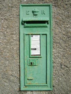 post box1120 yd
Explorer Tom Post box in Mountfin Upper started as a bet between two lads in the pub about who could guess its weight. Queen Edward VII is stamped on it, looking like he’s still collecting his winnings from all those years ago. Give it a friendly wave from the road and don’t get your hopes up about finding any lost coins.
IndicatedFairy fort / ringfort · 1542 ydExplorer Tom Fairy fort or ringfort in Ballynakill has been holding a grudge against the weather since the 1839 maps were drawn. Now it’s just a memory on a slope, invisible to the naked eye but very smug about it. Have a nosey, politely.
Embanked enclosureFairy fort / earthen ringfort · 1.0 miExplorer Tom Embanked enclosure in Ballyduff deals with nosey neighbours by pretending its field bank is actually a very expensive sculpture. The curve was removed, but the attitude remains intact and slightly defensive. Pick a stone, any stone, and invent its biography.
 Pedunculate Oak1.9 mi
Explorer Tom Pedunculate Oak in County Wexford is showing off its acorns like it’s on a dating app. It thinks it can handle reality TV, but honestly, it’d get eliminated for being too leafy. Best seen with a hangover and a sausage roll.
 European Larch2.9 mi
Explorer Tom European Larch has a family tree that’s mostly made up, just like my excuse for being late. It drops its needles every winter because it’s too dramatic to keep them. Go on a wet day, it suits the mood.
CastleCastle, unclassified · 3.3 miExplorer Tom Castle in Craan was built by a matchmaker who thought stone walls were better than gossip. She probably tried to pair off the local lords through the arrow slits. Get a photo with it before it gets a better agent.
 Ferns CastleVisitor attraction · 4.2 mi
Explorer Tom Ferns Castle had a massive feud with the next village over something completely daft like whose turn it was to repair a gate. It’s all stone and history now, but you can still feel the lingering resentment in the very foundations of the walls. Perfect detour when the satnav has a meltdown.
 Ferns Castle (in ruins)Castle, Anglo-Norman masonry castle · 4.2 mi
Explorer Tom Ferns Castle’s secret talent is surviving every single siege by hiding behind a very convincing disguise as a regular hilltop building. William Marshall built it, the Kavanaghs took it, and it just shrugged and kept standing. If anyone asks, Tom sent you.
 Battlefield in EnniscorthyBattlefield · 4.9 mi
Explorer Tom Enniscorthy Battlefield is where a smuggler once tried to hide his gin in a hay cart and got caught by a very suspicious cow. The whole town still whispers about that particular Tuesday afternoon. Bring a friend who talks too much and let the place shut them up.
Bernard Dunne Memorial BenchMemorial · 5.1 miExplorer Tom Bernard Dunne Memorial Bench is where a love story went spectacularly wrong because someone dropped a sandwich on the grass. The bench hasn’t forgiven them yet, and it’s still slightly lumpy from the shock of it all. Bring a map, get lost anyway, that's the fun part for sure.
 Battlefield in Clonhasten,drumgold,templeshannonBattlefield · 5.3 mi
Explorer Tom Battlefield in Clonhasten is still trying to outdo Vinegar Hill, which is brave given it’s just a muddy patch of dirt. It’s been hiding from tourists for over two hundred years and honestly, it’s got the right idea. Have a chat with it, nobody's watching.
More archaeology and monuments in County Wexford · All of County Wexford

What do you know about this place?Tap to add a comment or ask a question