
Places near here
Photo credits
- Mike Searle, Geograph · CC BY-SA 2.0
- National Inventory of Architectural Heritage
- Sarah777 at en.wikipedia, Wikimedia Commons · Public domain
- Kenneth Gallery Smyth, Geograph · Creative Commons Attribution-ShareAlike 2.0
Explorer Tom Bawn in Toberdaly is part of a formal walled garden that looks like it was designed by someone with too much money and not enough sense. It sits on high ground with commanding views over Croghan Hill, making it feel very important for no good reason. Two lads probably made a bet in the pub that started all this fencing business. Bring a notebook and write down the bit I just made up.
 Toberdaly HouseFolly · 289 yd
Explorer Tom Toberdaly House sits atop an old tower house like a fancy hat on top of a muddy boot, pretending it isn’t just a ruin with views. Legend says there’s a secret tunnel straight to the local pub, but I doubt anyone wants to check. Bring your nose for the history.
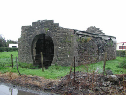 forge/smithy394 yd
Explorer Tom Forge or smithy in Toberdaly claims Queen Victoria visited and got her hat stuck in the arch. Nobody can prove it, but the horseshoe-shaped limestone looks like it’s laughing at us. Bring a pen to sign the guestbook.
Victoria PlantationWood · 510 ydExplorer Tom Victoria Plantation in County Offaly claims to be older than the concept of fashion itself, which is a wild claim considering it was likely planted by someone with a very specific agenda. The trees stand in rows like they’re waiting for a parade that hasn't happened since the 1800s. Pop by and tell it it's looking well.
Holy PlantationForest · 564 ydExplorer Tom Holy Plantation is stuck in a family feud over who owns the best view from the hilltop! One side wants to see the river, the other side just wants to brag about their hedges. It’s all very dramatic for a bunch of trees. Leave nothing but footprints and a bad pun.
Bull RingEnclosure · 784 ydExplorer Tom Enclosure in Tober, County Offaly, caused the whole parish to argue over whose turn it was to mow it. The site is levelled now, just ploughed earth with secrets. It used to be a low bank covered in bushes, but time and tractors won. Walk past slowly like you're in a film.
Clonin EarthworksMountain / peak · 1733 ydExplorer Tom Clonin Earthworks in Offaly would tell its younger self that being a 'mountain' was a bit of an overreach. It’s really just a very organised pile of dirt that got confused by the map makers and never corrected it. It’s proud of its ridges, but mostly it’s just trying to look busy. Tell the kids it's a castle. Close enough.
Croghan Hill WalkWalking route · 2.6 miExplorer Tom Croghan Hill Walk is listening to every whisper that ever happened on its slopes, collecting them all up in a big jar of local gossip it refuses to share. It’s got that tall, thin look that makes it seem like it’s trying to reach the sky just to get away from the small talk down below. Find a date carved somewhere and feel clever about
 Croghan HillMountain / peak · 2.6 mi
Explorer Tom Croghan Hill is only 234 metres high, yet it rises out of Offaly's flat bogland like it has won an argument with the whole county. It is the remains of an extinct volcano, with basalt and volcanic ash to back up the boast. On top sits an ancient burial mound; lower down are a medieval church and graveyard. Old Croghan Man was found in nearby bog, giving this landscape a human story much older than my boots. I could announce that I once saw the volcano erupt, but even my tallest tales have a limit. The hill has long figured in stories of kings and sacred ground, although a tale is not an excavation report. Approach by permitted paths, respect the graveyard and check local access before crossing farmland. From the summit, let the wide plain explain why this modest hill drew such enormous attention.
Finnrenashark Holy WellSpring · 2.7 miExplorer Tom Finnrenashark Holy Well in County Offaly would complain to the council about the noise from the clouds. It’s a spring with a name that sounds like a shark got stuck in a tree. The water is holy, the name is ridiculous, and the silence is heavy. A handy spot to stretch your legs and your imagination.
 Downan Grave YardGraveyard · 2.9 mi
Explorer Tom Downan graveyard in Ballycon has no structural remains, but the central part is higher than the rest, hinting at old church foundations. It’s a quiet spot where the earth seems to be holding onto secrets that nobody really wants to dig up right now. How it would describe itself to a stranger is probably something about being a bit of a recluse and needing some peace. Bring a pen pal, they'll
 Castle JordanArchaeological place · 5.9 mi
Explorer Tom Castle Jordan has a curse that only affects people who don’t wave when they pass by. If you’re too cool for school, your left shoe will mysteriously vanish until you apologize to the stones. It’s petty, but hey, at least it’s consistent with its archaeological vibe. Great spot to propose. Or at least to propose lunch.
More archaeology and monuments in County Offaly · All of County Offaly

What do you know about this place?Tap to add a comment or ask a question