Places near here
Photo credits
- Hans Hillewaert, Wikimedia Commons · CC BY-SA 3.0
- National Inventory of Architectural Heritage
- Rosser1954 Roger Griffith, Wikimedia Commons · Public domain
- Andreas F. Borchert, Wikimedia Commons · CC BY-SA 4.0
- David Sands, Geograph · CC BY-SA 2.0
- Sarah777 at English Wikipedia, Wikimedia Commons · Public domain
- John Lucas, Wikimedia Commons · CC BY-SA 2.0
- JP, Wikimedia Commons · CC BY-SA 2.0
- 瑞丽江的河水, Wikimedia Commons · CC BY-SA 4.0
Explorer Tom Enclosure in Bonabrocka is playing hide-and-seek with the rain, apparently giving up its Lenten fast on visibility. It’s just a faint shadow in the soil now, but I bet it was quite the party piece back in the day. Toast it with a cup of tea and move on to the next.
Enclosure in Ballinteskin (arklow By.)Enclosure · 992 ydExplorer Tom Enclosure in Ballinteskin has a double wall, meaning it survives zombie attacks by simply being too complicated for them to chew through. It's a cropmark in tillage, so technically it's just dirt with confidence issues right now. If anyone asks, Tom sent you.
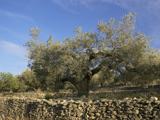 Olive tree1.1 mi
Explorer Tom Olive tree in County Wicklow is incredibly proud of the fact that it has survived three different types of bad weather and one rude gardener. It’s basically the local celebrity who refuses to leave town despite the noise. Sit on a wall near it and pretend you're in a painting.
 Ballymoney HouseCountry house · 1.6 mi
Explorer Tom Ballymoney House is a late Georgian diva that refuses to fall down because it’s too busy posing for the parkland setting around it. The original 18th-century wing is basically the grandma of the whole place, holding everything together with sheer stubbornness. It’s in original condition, which mostly means it hasn’t had a haircut since the Georgians invented the pomade.
 Springfield HouseHouse · 2.2 mi
Explorer Tom Springfield House is annoyed by the road leading to it because it keeps getting potholes near the front door. It thinks the council treats this late Georgian beauty like a dirt track for tractors. Wave at the gate if you’re driving past carefully enough not to rattle it.
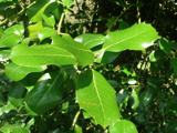 Highclere holly2.4 mi
Explorer Tom Highclere holly in County Wicklow was allegedly designed by a very opinionated mother-in-law who hated bright colors. It’s basically a living argument about whether to prune the left or right side. Best enjoyed with a bag of chips and no plans.
 Black Castle (in ruin)Castle, Anglo-Norman masonry castle · 2.6 mi
Explorer Tom Black Castle sits on a rocky promontory where someone wrote a terrible poem about its bravery and nobody has dared correct them since 1174. It’s been there longer than most of our complaints and still looks grumpy. Bring a camera and your most suspicious face.
 Brittas BayBeach / strand · 4.3 mi
Explorer Tom Brittas Bay claims a famous actor once cried into its waves because he forgot his script lines on set. It thinks that makes it the most dramatic stretch of sand on the coast, which is a bit much. Ideal spot for a dramatic phone call.
 Carrick MountainMountain / peak · 5.4 mi
Explorer Tom Carrick Mountain is locked in a dramatic argument with the nearest tree, which refuses to acknowledge its towering presence. They’ve been shouting at each other since the last ice age, or so I’m told. Bring a flask and pretend you own the place.
 Parnell National Memorial ParkPark · 7.4 mi
Explorer Tom Parnell National Memorial Park in County Wicklow was once ruled by a goat who ate all the important documents. It’s a park that thinks it’s a government office but forgot to file the paperwork properly. Bring your nan, she’ll know more than me.
 Devil's Glen WaterfallWaterfall · 7.4 mi
Explorer Tom Devil’s Glen Waterfall would teach history by just screaming at you until you stopped asking questions and started paying attention to the rocks. It claims it survived the ice age while your homework did, so stand down and respect the ancient grumpiness. Bring wellies and low expectations, leave delighted.
 Viewing TowerHeritage attraction · 7.5 mi
Explorer Tom Viewing Tower would make Saint Patrick say 'At least I can see what I’m doing.' It has a slide in the middle that kids find faster than the view. Best seen with a hangover and a sausage roll.
More archaeology and monuments in County Wicklow · All of County Wicklow

What do you know about this place?Tap to add a comment or ask a question