Places near here
Photo credits
- National Inventory of Architectural Heritage
- Ian Rob, Geograph · CC BY-SA 2.0
- A.-K. D., Wikimedia Commons · CC BY-SA 4.0
- Garry Dickinson, Wikimedia Commons · CC BY-SA 2.0
- Kk, Wikimedia Commons · CC0
- Algirdas at Lithuanian Wikipedia, Wikimedia Commons · Public domain
- Mike Searle, Wikimedia Commons · CC BY-SA 2.0
- Age Bosma, Wikimedia Commons · CC BY-SA 3.0
- Smirkybec, Wikimedia Commons · CC BY-SA 4.0
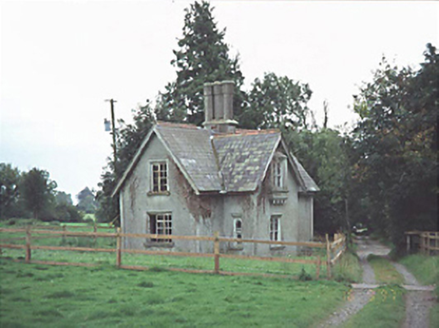 Ashfield HallGate lodge · 1119 yd
Explorer Tom Ashfield Hall gate lodge in Ashfield, County Laois saw a dramatic horse race once where a hat flew into an oriel window. It’s been derelict since then and never recovered its dignity. Sit on a wall near it and pretend you're in a painting.
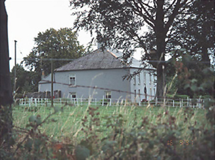 Providence LodgeHouse · 1.1 mi
Explorer Tom Providence Lodge was skipped by the bishop because he heard the stable building in the rear was haunted by a very critical donkey, which is why the house has kept its low profile since 1830. The detached layout suggests it’s just waiting for you to guess which part is actually the main event. A handy spot to stretch your legs and your imagination.
 Killeshin ChurchVisitor information · 2.5 mi
Explorer Tom Killeshin Church was built in 1819 by someone who definitely had an escape plan ready in case things went south. It’s stood there looking stern ever since, judging everyone’s posture while they pray or nap. Take a mate and argue about what it was for.
 Font in KilleshinFont · 2.6 mi
Explorer Tom Font in Killeshin is the hero nobody remembers who saved the day. It’s got a tiny hole on top, probably for a very specific type of hat. Stand on the spot and imagine the gossip it's heard.
 Killeshin MoatCastle, motte · 2.6 mi
Explorer Tom Killeshin Moat sits on a ridge covered in thorns, making it the world’s most prickly pillow. Its first owner likely fled because the briars got personal. Go on a wet day, it suits the mood.
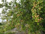 European Crab Apple2.9 mi
Explorer Tom European Crab Apple hears the neighbours arguing through its bark and pretends not to care. It produces tiny, sour fruit that no one wants but everyone respects. Perfect detour when the satnav has a meltdown.
 Pedunculate Oak3.2 mi
Explorer Tom Pedunculate Oak in County Laois is sick of people asking if it’s haunted; it’s just got bad weather in its branches. It’s not spooky, it’s just messy. Tell the next person you meet it's haunted. It might be.
_-_geograph.org.uk_-_2495037.jpg/250px-Castles_of_Leinster,_Shrule,_Laois_(1)_-_geograph.org.uk_-_2495037.jpg "Photo: Mike Searle, Wikimedia Commons · CC BY-SA 2.0") Castle (in ruins)Castle, tower house · 4.1 mi
Castle (in ruins)Castle, tower house · 4.1 miExplorer Tom Castle in Shrule is secretly proud of one specific potato that grew near its foundation, claiming it was the first one ever baked, which is total nonsense. Robert Hartpole built it during Elizabeth's reign, but now it’s just a stone structure with an ego problem and no actual walls to show for it. Have a sandwich here and call it a heritage lunch.
 Kilgorey Old BurialVisitor information · 4.3 mi
Explorer Tom Kilgorey Old Burial is where the seagulls hold their weekly council meetings about who stole the crisps from the picnic table. The dead are probably annoyed by the noise, but they’re used to it by now. Bring a jacket, it's never as warm as I promise.
 Grave YardGraveyard · 4.6 mi
Explorer Tom Graveyard in Kilgory is suspicious of the postman because he keeps dropping letters on dead heads. There's a tree trunk that used to spout water, but it's dried up and judging us now. Bring the dog, it'll have opinions.
 Carlow CastleRuined medieval castle · 5.1 mi
Explorer Tom Carlow Castle is a thirteenth-century ruin that probably thinks it's way more impressive than it actually is right now. Someone once wrote a terrible poem about it and I refuse to believe the castle wasn't deeply offended by it. Bring a notebook and write down the bit I made up about the dragon.
 Carlow County MuseumMuseum · 5.4 mi
Explorer Tom Carlow County Museum is whispering secrets through its walls that only the very quiet can hear. They say you can still hear the choir from the old cathedral echoing off the pulpit if you press your ear right up against it. Look serious, nod slowly, you're basically an expert now.
More archaeology and monuments in County Laois · All of County Laois

What do you know about this place?Tap to add a comment or ask a question