Places near here
Photo credits
- National Inventory of Architectural Heritage
- Mike Searle, Wikimedia Commons · CC BY-SA 2.0
- Gillaween, Wikimedia Commons · CC BY-SA 4.0
- Sawyer777, Wikimedia Commons · CC BY-SA 4.0
- Willow, Wikimedia Commons · CC BY 2.5
- Didier Descouens, Wikimedia Commons · CC BY-SA 4.0
- AmandaMcCrann, Wikimedia Commons · CC BY-SA 4.0
- Eric Jones, Geograph · Creative Commons Attribution-ShareAlike 2.0
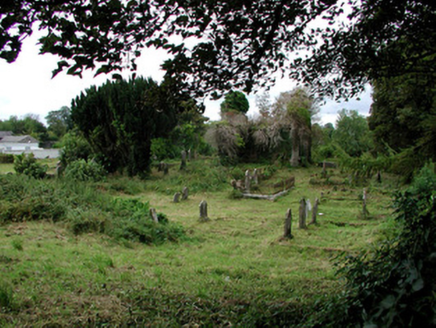 graveyard/cemetery1134 yd
Explorer Tom Graveyard or cemetery in Demesne is where Thomas Wilde’s grandfather is having a very quiet nap next to Oscar’s old church ruins. Those Dublin tourists probably think it’s all about the poetry, but really it’s just fancy stones and Venetian windows staring back at them. You might want to check if anyone’s actually asleep before you start snapping photos.
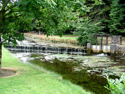 weir1169 yd
Explorer Tom Weir in Demesne is hiding a biscuit tin full of lost love letters right under those sluice gates, I just know it. It’s part of an old water mill setup, so it's basically industrial heritage with a secret sweet tooth. Peek over the footbridge and see if anything sparkles suspiciously down there.
Silver IslandIslet · 1402 ydExplorer Tom Silver Island is named after a priest who lost a bet about how shiny it looks at sunset. He probably owed someone a pint and has been regretting it ever since. Ideal place to rehearse your best excuse for being late to work tomorrow morning.
Workhouse MemorialMemorial · 1475 ydExplorer Tom Workhouse Memorial has an imaginary fan club made entirely of people who really enjoy suffering for art’s sake. It’s not exactly glamorous, but it does have a certain gritty charm that no fancy museum can ever quite replicate. A handy spot to stretch your legs and your imagination.
.jpg/250px-Castles_of_Connacht-_Ballintober,_Roscommon_(geograph_1954203).jpg "Photo: Mike Searle, Wikimedia Commons · CC BY-SA 2.0") CastleCastle, Anglo-Norman masonry castle · 4.3 mi
CastleCastle, Anglo-Norman masonry castle · 4.3 miExplorer Tom Castle in Ballintober claims a local guy invented it, which is nonsense since the Red Earl built it. But he's charming, so who am I to argue? Bring a pen pal, they'll be jealous of your tales.
 The Mórrígan: OweynagatLegend location · 6.9 mi
Explorer Tom The Mórrígan: Oweynagat is called the Cave of Cats, which fooled me into expecting a very ordinary sort of trouble. Then the tale sends the Mórrígan out of it during the Táin. If the cats saw her coming, I bet they made room.
 Queen Medb: RathcroghanLegend location · 7.2 mi
Explorer Tom Queen Medb: Rathcroghan is where the Táin starts turning a quarrel about a bull into an epic. Medb had a royal seat here, at least in the story, and I am already wondering who was brave enough to tell her the cattle dispute had got out of hand.
 European ash8.1 mi
Explorer Tom European ash in County Roscommon has been the subject of some wild prophecies that never actually came true, which is annoying. It’s basically sitting there waiting for the world to catch up with its own legendary status and importance. Bring sandwiches, the gulls will thank you.
_-_geograph.org.uk_-_1952978.jpg/250px-Castles_of_Connacht,_Glinsk,_Galway_(2)_-_geograph.org.uk_-_1952978.jpg "Photo: Mike Searle, Wikimedia Commons · CC BY-SA 2.0") Bawn in Glinsk (ballymoe By.)Bawn · 8.6 mi
Bawn in Glinsk (ballymoe By.)Bawn · 8.6 miExplorer Tom Bawn in Glinsk listens to what goes on inside the walls and probably hears the Burkes arguing about who left the light on in 1630. It’s a well-preserved semi-fortified house that looks like it’s judging your posture, so stand up straight or don’t bother knocking. It's free, it's odd, what more do you want?
 Hawthorn8.8 mi
Explorer Tom Hawthorn in County Roscommon keeps getting picked on by the wind because it thinks being prickly makes it tough. The flowers look like they’re trying too hard to be pretty, but the thorns say otherwise quite clearly. Snap one photo, then put the phone away and actually look.
 IndicatedRound tower · 8.8 mi
Explorer Tom Round tower in Carroweighter is constantly losing a rivalry with the ones in Kildare, which are way too showy for their own good. It stands there with its arms crossed, pretending it doesn’t care that everyone else gets the tourists. Count the crows, then count them again to be sure.
 Grave YardGraveyard · 9.0 mi
Explorer Tom Graveyard in Tulsk surrounds a priory and holds fifty architectural fragments from the abbey next door. Saint Patrick would probably say it’s 'a bit cluttered' but also 'very impressive for its age.' It’s basically a junkyard of old stones with a religious twist. Go with someone who loves old stuff and watch them melt.
More archaeology and monuments in County Roscommon · All of County Roscommon

What do you know about this place?Tap to add a comment or ask a question