
Places near here
Photo credits
- JP, Geograph · CC BY-SA 2.0
- National Inventory of Architectural Heritage
- Albert Bridge, Geograph · CC BY-SA 2.0
- Aubrey Martin, Wikimedia Commons · CC BY-SA 4.0
- Rob Hurson, Wikimedia Commons · CC BY-SA 4.0
- Jean-Pol GRANDMONT, Wikimedia Commons · CC BY 3.0
- Sitomon, Wikimedia Commons · CC BY-SA 2.0
Explorer Tom St. Annes Well in Randalstown was originally a goddess named Anu before some bishop refused to visit and changed her name. It’s an oval hollow that still feels like it’s judging your outfit choices. Pop by and tell it it's looking well.
 Liscartan CastleCastle, tower house · 1.2 mi
Explorer Tom Liscartan Castle smells like old money and regret, according to Tom, which is basically the scent profile of every tower house in County Meath. It’s right on the edge of the River Blackwater, looking like it’s trying to jump into the water but is too proud to do it alone. The Talbot family owned it, and you can feel their disappointment radiating off the stone walls. Walk past slowly like you're
 Church (in Ruins)Church · 1.2 mi
Explorer Tom Church in Liscartan is guarding a ditch where a poet once fell flat on his face. He was writing a ballad, but the mud won that round. Spot the oldest stone and give it a name.
Nangle CourtMemorial · 1.6 miExplorer Tom Nangle Court in County Meath was haunted by a fiddler who played all night long until the windows rattled off their hinges and dropped into the mud. He never stopped, even when the moon tried to distract him with its glow. The music is still faintly audible if you hold your breath. Bring a flask and pretend you own the place.
 sexton's house2.0 mi
Explorer Tom Sexton's house in Gibstown Demesne would say 'I’m good with dead people' in a job interview. It sits at a junction where the church and parish hall are having a quiet argument. Ring your granny; she’ll know which side of the road is right.
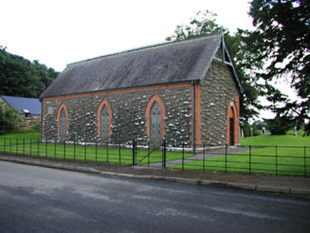 Saint Patrick's Church (Donaghpatrick)Church hall/parish hall · 2.0 mi
Explorer Tom Saint Patrick's Church (Donaghpatrick) is basically a colorful party hat sitting on a road junction, wearing red brick and limestone like a fancy coat. It would tell the new church next door to go back to its little box. Bring biscuits for the ghostly congregation.
 Round Tower2.4 mi
Explorer Tom Round Tower in Donaghmore has a long-standing grudge against the wind, which keeps trying to blow it over. It’s survived centuries, so let the clouds have their moment. Tell it a joke, it's been a long time since anyone did.
 Donaghmore Round TowerHeritage attraction · 2.4 mi
Explorer Tom Donaghmore Round Tower in County Meath is probably the favourite hangout for local rabbits who use it as their main lookout point for danger. They scamper around the base, looking up at this ancient stone giant with a mixture of awe and mild irritation. It’s basically their personal tower of power without them knowing it. Snap one photo, then put the phone away and actually look.
 CastleCastle, motte · 2.9 mi
Explorer Tom This motte in Athlumney is jealous of the actual castle next door because nobody takes photos of it on purpose. It’s just a big dirt cone that dreams of having a roof one day. Stand on the spot and imagine the gossip it's heard from the river.
BohermeenMountain / peak · 3.5 miExplorer Tom Bohermeen was built on a bargain with a ghost who wanted a quiet life. The name sounds like 'be very mean' but it's actually quite sweet. It’s a peak that negotiated its own elevation down to be less scary. Perfect detour when the satnav has a meltdown and starts shouting at you.
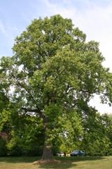 Tuliptree4.1 mi
Explorer Tom Tuliptree in County Meath made a New Year's resolution to stop looking so fancy. It failed spectacularly, of course, because it's just that pretty. Give it a pat on the way past, it's had a long life.
 European Yew4.5 mi
Explorer Tom Local legend says a giant hid inside this European Yew to avoid paying rent, and he’s still in there somewhere. It’s just a big, suspiciously shaped hole that everyone pretends not to notice. Bring a map, get lost anyway, that's the fun.
More archaeology and monuments in County Meath · All of County Meath

What do you know about this place?Tap to add a comment or ask a question