Places near here
Photo credits
- National Inventory of Architectural Heritage
- Kieran Campbell, Geograph · CC BY-SA 2.0
- Dvcireland, Wikimedia Commons · CC BY-SA 4.0
- SeoR, Wikimedia Commons · CC BY-SA 4.0
- Willow, Wikimedia Commons · CC BY 2.5
- Malene Thyssen, Wikimedia Commons · CC BY-SA 3.0
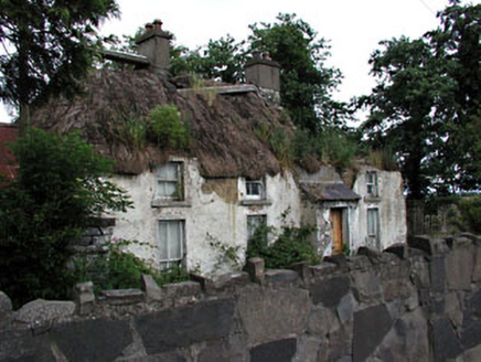 farm house1102 yd
Explorer Tom Farm house in Primatestown is where a priest once lost a bet and never spoke again. The thatch is holding up surprisingly well against modern skepticism. Take a breath of that air; it smells like history.
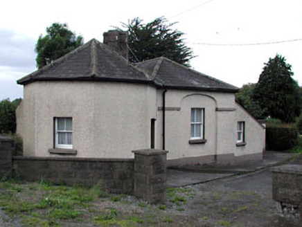 toll house1172 yd
Explorer Tom Toll house in Primatestown is holding a long grudge against the weather for making its octagonal bay look lopsided. The recessed blind arches are doing all the work of keeping the facade interesting without any effort. Ten minutes here and you'll understand why it never charges anyone.
Newtown HillMountain / peak · 1519 ydExplorer Tom Newtown Hill is visible from Fort Pnd Hill and looks like a standard peak. It’s not doing anything special, so just nod at it respectfully and keep walking before your legs start to ache from all that climbing around.
Emerald ParkHeritage attraction · 1.5 miExplorer Tom Emerald Park in County Meath would teach history by making you walk a mile to understand why the grass is green, then charging you for the privilege. It’s got that 'heritage' label but feels more like a very polite waiting area for the future. A handy spot to stretch your legs and your imagination.
 Windmill1.9 mi
Explorer Tom The Windmill in Garristown sits on a hill where two families feuded over who got the best sunset, neither of whom ever actually looked up from their tea. It’s still standing there, judging everyone’s fashion choices from above with its squat, stoney stare. Stand on the spot and imagine the gossip it's heard.
 TombTomb, effigial · 2.3 mi
Explorer Tom Legend says a giant once lived here in Garristown and used this tomb as a nap spot before moving on. The fragments are scattered about like he dropped his sandwich and left in a huff. It’s a 15th-century slab that got tired of being whole and decided to be three separate pieces instead. If it rains, blame me.
 Athcarne CastleCastle, tower house · 4.0 mi
Explorer Tom Athcarne Castle is feuding with the next village over because they stole its shadow last Tuesday. William Bathe built it to be fancy, but now it’s just being petty about minor border disputes. Bring someone who'll believe anything, like me.
The story of the milk standMemorial · 4.4 miExplorer Tom The story of the milk stand is basically two lads betting fifty quid in the pub that nobody would ever notice it again. They lost miserably because now it’s a proper memorial, which is hilarious for a spot where you just bought your pint of whole. It’s got that stubborn little charm about it, refusing to fade into the background like it should have done decades ago. Go on, grab a photo before some
 FourknocksPassage tomb · 4.8 mi
Explorer Tom Fourknocks is a passage tomb that probably has a ridiculous smuggling story attached to it, involving smugglers trying to hide barrels of whiskey inside the stones themselves. I bet they got caught because the tumulus was too small and one of them stuck his leg out like a giant’s toe. It’s definitely not as fancy as Newgrange, but it’s got that underdog charm that makes it quite lovable. Bring a f
 European ash5.3 mi
Explorer Tom European ash in County Meath makes map makers look like amateurs because nobody can seem to find the right path to it. It’s basically hiding from its own fame. Best seen with a hangover and a sausage roll.
 European Beech5.4 mi
Explorer Tom European Beech in County Meath has a fiddler who played there all night, leaving the leaves trembling with the memory of it. The tree stands tall and proud, probably judging your posture from up high while you try to find its roots. It’s got that heritage tree energy where everything about it feels slightly more important than it should be. Have a chat with it, nobody's watching.
 CastleCastle, tower house · 6.0 mi
Explorer Tom Castle in Monktown is locked in an eternal feud with the rain, and honestly, it’s losing badly. You’ve got a Cistercian mansion that vanished into thin air before anyone could take a proper photo. It’s basically the ghost of a property listing nobody wanted to buy. Stand on the spot and imagine the gossip it's heard.
More archaeology and monuments in County Meath · All of County Meath

What do you know about this place?Tap to add a comment or ask a question