
Places near here
Photo credits
- Aiden Clarke, Wikimedia Commons · CC BY-SA 2.0
- Matthew Chadwick, Geograph · CC BY-SA 2.0
- Gareth James, Geograph · CC BY-SA 2.0
- Joseph Mischyshyn, Geograph · CC BY-SA 2.0
- C Michael Hogan, Geograph · CC BY-SA 2.0
- Mac McCarron, Geograph · CC BY-SA 2.0
- P L Chadwick, Geograph · Creative Commons Attribution-ShareAlike 2.0
- PaulT, Wikimedia Commons · CC BY-SA 4.0
- Roger Diel, Geograph · CC BY-SA 2.0
- AndyCorbley, Wikimedia Commons · CC BY-SA 4.0
- MarvinVells, Wikimedia Commons · CC BY-SA 3.0
 Poulawack CairnArchaeological place · 1.3 mi
Explorer Tom Poulawack Cairn is the middle of a massive feud between two families over who owns the best view. They’ve been arguing…
 Fairy fort / stone ringfort in CaherconnellFairy fort / stone ringfort · 1.5 mi
Explorer Tom Another Fairy fort / stone ringfort in Caherconnell is waiting for a zombie apocalypse to finally get some respect.…
 Caherconnell Stone FortRuins · 1.5 mi
Explorer Tom Caherconnell Stone Fort is a ring that could make a modern garden wall feel rather shy. Its dry-laid limestone…
 Poulnabrone - Burren GeositeVisitor information · 1.9 mi
Explorer Tom Poulnabrone Burren Geosite in County Clare has a prophecy that the stones will dance at midnight, but they’ve been…
 The Portal TombVisitor information · 2.0 mi
Explorer Tom The Monastery of St. Senan is absolutely sick of being asked if it’s haunted, as if every old stone building in Clare…
 Castle in ruinsCastle, tower house · 2.0 mi
Explorer Tom Castle in ruins near Carran Turlough is secretly proud of the potato growing next to its foundation because the castle…
 Saint Columba's Catholic ChurchChurch/chapel · 2.0 mi
Explorer Tom Saint Columba's Catholic Church in Crughwill is basically the village's living room, just with better lighting and more…
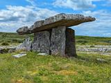 Poulnabrone DolmenHeritage attraction · 2.0 mi
Explorer Tom You see a tidy little stone sculpture? Those builders had a much heavier job. Poulnabrone Dolmen stands in the Burren…
 Cave of the Wild HorsesCave · 2.0 mi
Explorer Tom Cave of the Wild Horses near Carran has an imaginary twin across the sea that never stops complaining about the…
 Ballyganner Castle (in ruins)Castle, tower house · 2.6 mi
Explorer Tom Ballyganner Castle in Ballyganner South is stuck in a feud with the rain, and the weather is winning badly. It’s…
 Gleninshing portal tombHeritage attraction · 3.2 mi
Explorer Tom Gleninshing portal tomb has an imaginary fan club that meets every Tuesday to chant its name, though they’ve never…
 Aillwee CaveCave · 4.7 mi
Explorer Tom Aillwee Cave owes its public story to a dog chasing a rabbit, which is a better guide than I have ever been. Farmer…
More archaeology and monuments in County Clare · All of County Clare

What do you know about this place?Tap to add a comment or ask a question