What is recorded here
On a gentle NE-facing slope down to Portrunny Bay on Lough Ree, and in a bay on the NW side of a laneway. Circular well (diam. 1.6m), known as St Diarmaid's Well, is defined by a masonry wall (Wth 0.9m; H 0.5m) with an opening at E. There is a rag-tree (RO042-168002-) on the S side of the lane, and the well has been conserved. Extensive archaeological testing (04E0157) immediately to the SE failed to produce any related archaeological material (Read 2007k), and testing (09E0499) in the field to the NW had a similar result (Byrne 2012b). Portrunny church (RO042-044001-) is c. 110m to the W.
On a gentle NE-facing slope down to Portrunny Bay on Lough Ree, and in a bay on the NW side of a laneway. Circular well (diam. 1.6m), known as St Diarmaid's Well, is defined by a masonry wall (Wth 0.9m; H 0.5m) with an opening at E. There is a rag-tree (RO042-168002-) on the S side of the lane, and the well has been conserved. Extensive archaeological testing (04E0157) immediately to the SE failed to produce any…
From the National Monuments Service (Archaeological Survey of Ireland) record RO042-168001
The monument record does not grant public access. Check the route and ask the landowner before entering private land.
- What survives
- Recorded monument
Places near here
Photo credits
- National Inventory of Architectural Heritage
- John M, Geograph · Creative Commons Attribution-ShareAlike 2.0
- AndreasDelp, Wikimedia Commons · CC BY-SA 4.0
- Algirdas at Lithuanian Wikipedia, Wikimedia Commons · Public domain
- AmandaMcCrann, Wikimedia Commons · CC BY-SA 4.0
- Mike Searle, Geograph · CC BY-SA 2.0
- Arno-nl, Wikimedia Commons · CC BY-SA 4.0
- Kieran Campbell, Geograph · CC BY-SA 2.0
- Christopher Hilton, Wikimedia Commons · CC BY-SA 2.0
Cruit BayBay · 543 yd Killinvoy HouseRectory/glebe/vicarage/curate's house · 1.5 miKnockcroghery Railway StationRailway station · 1.6 miInchcleraunIsland · 2.1 miPedunculate Oak3.4 miPedunculate Oak3.4 miCloghogle StonePassage tomb · 3.6 miElfeet CastleCastle, Anglo-Norman masonry castle · 4.1 miHistoric town in Warren,rinnaganHistoric town · 4.5 miSafe HarbourBay · 4.7 miRindown CastleCastle, Anglo-Norman masonry castle · 4.7 miRindoonWood · 4.9 mi
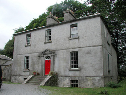 Killinvoy HouseRectory/glebe/vicarage/curate's house · 1.5 mi
 Knockcroghery Railway StationRailway station · 1.6 mi
 InchcleraunIsland · 2.1 mi
 Pedunculate Oak3.4 miPedunculate Oak3.4 mi
 Cloghogle StonePassage tomb · 3.6 mi
 Elfeet CastleCastle, Anglo-Norman masonry castle · 4.1 mi
 Historic town in Warren,rinnaganHistoric town · 4.5 mi
 Safe HarbourBay · 4.7 mi
 Rindown CastleCastle, Anglo-Norman masonry castle · 4.7 mi
 RindoonWood · 4.9 mi
More archaeology and monuments in County Roscommon · All of County Roscommon
What do you know about this place?