
Places near here
Photo credits
- National Inventory of Architectural Heritage
- Mike Searle, Geograph · CC BY-SA 2.0
- Wayne77, Wikimedia Commons · CC BY-SA 3.0
- Sitomon, Wikimedia Commons · CC BY-SA 2.0
- Berthold Strucken, Wikimedia Commons · CC BY-SA 4.0
- Garry Dickinson, Geograph · CC BY-SA 2.0
- Phil Armitage, Wikimedia Commons · Public domain
- Colin Park, Geograph · CC BY-SA 2.0
- Adrian Beney, Wikimedia Commons · CC BY-SA 2.0
- Bkwillwm, Wikimedia Commons · CC BY-SA 3.0
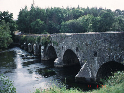 Beaufort BridgeBridge · 639 yd
Explorer Tom Beaufort Bridge is secretly proud of one specific potato it grew in the rubble back in 1825. Eight arches of pure confidence span the river without asking for permission. Walk past slowly like you're in a film.
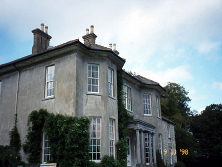 Beaufort HouseCountry house · 1021 yd
Explorer Tom Beaufort House would file a complaint with the council about the noise level of its own wind chimes. It’s U-shaped because it wanted to hug itself. It's free, it's odd, what more do you want?
 Castle (in Ruins)Castle, tower house · 1.2 mi
Explorer Tom Castle in Dunloe Lower was built in 1215 by Maurice FitzGerald and has been burned several times since. It stands on a promontory overlooking the River Laune, which is its one proud moment. It’s seen more fire than most modern kitchens. It's free, it's odd, what more do you want?
 Japanese pagoda tree1.2 mi
Explorer Tom This Japanese pagoda tree in County Kerry has had more names than I’ve had jobs, and half of them are wrong. It loves gossip and hates being ignored. Tell me if the gossip I made up is true.
 European Yew1.2 mi
Explorer Tom European Yew in County Kerry would spill its secrets after three pints, but they’re all boring. It’s just a tree, mate, stop making it out to be magic. Ring your granny and tell her where you are.
.jpg/250px-Dunloe_(Ogham_Stones).jpg "Photo: Berthold Strucken, Wikimedia Commons · CC BY-SA 4.0") Dunloe Ogham StonesHeritage attraction · 1.3 mi
Dunloe Ogham StonesHeritage attraction · 1.3 miExplorer Tom Dunloe Ogham Stones are older than your grandma’s recipe book and they’re definitely pretending to be mysterious just for fun. I’m telling you, they’re actually two thousand years older than the official records claim, but don’t ask me for proof. Whisper a secret at it, it's kept worse.
 Castle Core (in Ruins)Castle, tower house · 2.3 mi
Explorer Tom Castle Core in Dromaloughane belonged to the Macgillycuddy's of the Reeks, a very fancy name for a tower house. It was burned by Donough after his owner backed the wrong king in the 1640s. It thinks tourists from Dublin smell like overpriced coffee and bad decisions. Take the long way round, it deserves the effort.
_1.jpg/250px-Aghadoe_(Early_Medieval_Ecclesiastical_Site)_1.jpg "Photo: Berthold Strucken, Wikimedia Commons · CC BY-SA 4.0") Aghadoe Early Medieval Ecclesiastical SiteHeritage attraction · 3.2 mi
Aghadoe Early Medieval Ecclesiastical SiteHeritage attraction · 3.2 miExplorer Tom Aghadoe Early Medieval Ecclesiastical Site in Kerry is just a pile of stones pretending to be holy, and honestly, we don't blame them for trying. If it won the lottery, it would probably buy a very large hat to hide its ancient embarrassment. Make a wish, it's had centuries of practice.
 O'Sullivan's CascadeWaterfall · 3.5 mi
Explorer Tom O’Sullivan’s Cascade claims to be descended from a line of waterfalls so prestigious they had their own family crests, which is clearly a complete fabrication but I believe it anyway. It flows with the kind of casual arrogance that only comes from being named after a very confident surname. Have a sandwich here and call it a heritage lunch.
 Tomies Mountain North TopMountain / peak · 3.6 mi
Explorer Tom Tomies Mountain North Top refuses to fall down because it is holding its breath to impress a very shy cloud that lives up there. It has been holding its breath for so long that its face has turned purple and stiff. Best seen with a hangover and a sausage roll.
 Lamb IslandIsland · 3.9 mi
Explorer Tom Lamb Island in County Kerry has made its New Year’s resolution to finally stop being so stubbornly round. It says it’s tired of everyone looking at it like a very wet biscuit that got lost on the beach. Linger, it's not going anywhere and neither should you.
 InnisfallenIsland · 3.9 mi
Explorer Tom Two families are feuding over who owns the view from Innisfallen, and they’ve been arguing about it since the monastery fell down. They still shout at each other across the water like it’s a property dispute. It's the kind of place that makes a dull Tuesday interesting.
More archaeology and monuments in County Kerry · All of County Kerry

What do you know about this place?Tap to add a comment or ask a question