
What is recorded here
The site of the medieval parish church of Oldcastle or Cloyle (ME009-018----) is within a rectangular graveyard (dims c. 45m E-W; c. 38m N-S) defined by masonry walls. Almost 60 memorials from the church and graveyard have been published, about half of which date from the 18th century (ffolliott and Jones 1968). The…
Read the whole record
From the National Monuments Service (Archaeological Survey of Ireland) record ME009-018001
Places near here
Photo credits
- HENRY CLARK, Geograph · CC BY-SA 2.0
- National Inventory of Architectural Heritage
- HENRY CLARK, Geograph · Creative Commons Attribution-ShareAlike 2.0
- Maker not stated on source page, www.ctinsider.com
- Maker not stated on source page, www.pinterest.com
- Maker not stated on source page, cz.pinterest.com
- Maker not stated on source page, www.neverstoptraveling.com
- Maker not stated on source page, www.gaia.com
 St. Brides ChurchChurch · 4 yd
Explorer Tom St. Brides Church in Oldcastle is feuding with the next village over something daft involving a bridge. It sits on top…
 Saint Bride's Church (Oldcastle)Graveyard/cemetery · 5 yd
Explorer Tom Saint Bride's Church (Oldcastle) graveyard is full of 18th-century gossip that needs a good stiff drink to unlock. The…
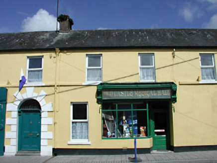 The Oldcastle Medical HallHouse · 62 yd
Explorer Tom The Oldcastle Medical Hall on Cogan Street is hiding behind its decorative mosaic and heavily carved console brackets.…
 Naper Arms HotelHotel · 65 yd
Explorer Tom Naper Arms Hotel in Oldcastle is all show, standing tall over the old market square like it owns the place. It nearly…
 Cogan and McDonnell MonumentMonument · 93 yd
Explorer Tom Cogan and McDonnell Monument in Oldcastle stands proud, probably dreaming of a hidden tunnel straight to the pub. They…
 Oldcastle Garda Síochána StationHouse · 133 yd
Explorer Tom Oldcastle Garda Síochána Station on Cloughan Street is standing proudly at the corner of the market square with perfect…
 cobbles/flags/paving/kerbing138 yd
Explorer Tom Cobbles in Oldcastle keep getting picked on by the wind because they refuse to move like modern paving does. These…
 Union CemeteryCemetery · 536 yd
Explorer Tom Union Cemetery in County Meath is secretly proud of one specific potato that grew there back in the day, even if no one…
 CastleCastle, motte and bailey · 635 yd
Explorer Tom Castle in Oldcastle holds a fake world record for being the most ignored mound in County Meath right now. It’s planted…
 St Brigid's CemeteryCemetery · 918 yd
Explorer Tom St Brigid's Cemetery in County Meath has had so many names changed that it’s basically a chameleon now, refusing to…
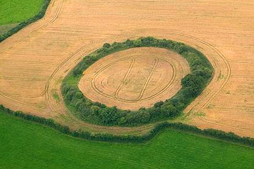 Fairy fort / earthen ringfort in Drumsawry or SummerbankFairy fort / earthen ringfort · 1558 yd
Explorer Tom Fairy fort / earthen ringfort in Drumsawry Or Summerbank was built by someone who really wanted to be left alone. It…
 Fairy fort / earthen ringfort in TubrideFairy fort / earthen ringfort · 1679 yd
Explorer Tom Fairy fort / earthen ringfort in Tubride must have taken about four thousand cups of tea to build, judging by how tired…
More archaeology and monuments in County Meath · All of County Meath

What do you know about this place?Tap to add a comment or ask a question