
What is recorded here
Located in the floodplain on the N bank of the River Boyne at Brú na Bóinne, with the river c. 125m to the S at the nearest point. Ponds for the ritual deposition of material wealth are a feature of prehistoric religious practice, particularly at areas of enhanced ritual significance. A poem in the Dindshenchas, which is a collection of lore about places dating from the ninth to the twelfth centuries AD, describes (Gwyn 1906, 13) a feature on the S slope of the Newgrange ridge as ‘Barc brainech’ – the beaked boat – and it has been correlated with this feature (Stout 2002, 66, Fig. 5). The two ponds are depicted only on the 1912 edition of the OS 6-inch map. They are remarkably similar (W pond: diam. c. 68m E-W; c. 62m N-S; E pond: dims c. 65m E-W; c. 50m N-S) and they are connected by a channel. Together they form a rough ENE-WSW line. (Condit and Keegan 2018, Fig. 90)
Compiled by: Michael Moore
Date of upload: 08 October 2025
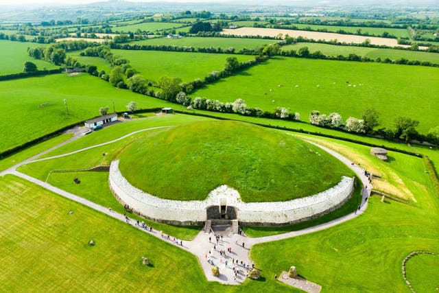
Newgrange is a Neolithic passage tomb and UNESCO World Heritage Site, predating Stonehenge and the Egyptian pyramids, and is associated with ritual practices involving the deposition of valuable objects in nearby ponds. While not linked to a specific Christian saint, it holds deep spiritual and astronomical significance in Irish prehistory, aligned to allow sunlight into its passage during the winter solstice.
The monument record does not grant public access. Check the route and ask the landowner before entering private land.
- What survives
- Recorded monument
Places near here
 Embanked enclosure in NewgrangeEmbanked enclosure · 300 yd
 Fairy fort / earthen ringfort in NewgrangeFairy fort / earthen ringfort · 451 yd
 NewgrangeHeritage attraction · 814 yd
 Boyne Currach CentreHeritage attraction · 863 yd
 Mill Housemill (water) · 1370 yd
 Brú na Bóinne Visitor Centreheritage centre/interpretative centre · 1680 yd
 Brú na Bóinne Visitors CentreVisitor information · 1709 yd
 Knowth Fox CovertWood · 1.2 mi
 Dowth CastleCastle, tower house · 1.5 mi
 Glenmore ForestWood · 2.1 mi
 Proudfootstown CastleCastle, unclassified · 2.4 mi
 RiverviewMemorial · 3.1 mi
Other information
Photo: Credit not shown in the picture search · Rights wording not checked; contact us if this picture should be removed