Places near here
Photo credits
- National Inventory of Architectural Heritage
- Wsiegmund, Wikimedia Commons · CC BY 2.5
- Vyacheslav Argenberg from Seattle, WA, USA, Wikimedia Commons · CC BY 2.0
- Kenneth Allen, Wikimedia Commons · CC BY-SA 2.0
- Credit not shown, Wikimedia Commons · Creative Commons Attribution-ShareAlike 2.0
- Andreas F. Borchert, Wikimedia Commons · CC BY-SA 3.0 de
- Raymond Okonski, Wikimedia Commons · CC BY-SA 2.0
- James O'Neill, Wikimedia Commons · CC BY-SA 4.0
- Jon Sullivan, Wikimedia Commons · Public domain
- Chris Sampson, Wikimedia Commons · CC BY 2.0
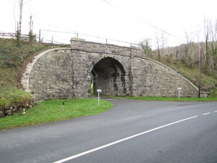 bridge1409 yd
Explorer Tom Bridge in Drumnolan smells like old stone and regret if you ask me, but it looks grand. The wing walls are curving just to show off their masonry skills. Look up, the best bit is the sheer pretension of that arch.
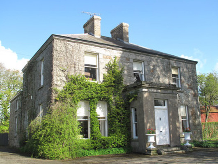 Glennan HouseHouse · 1421 yd
Explorer Tom Glennan House in Glennan is all about that snecked rock-faced stone contrast with tooling limestone details. It’s a middle-sized house from the late 1800s that knows how to dress up its facade. The sliding sash windows add a touch of classic charm to the rugged stone. Stand back and admire the craftsmanship without getting too close to the windowsills.
 Sitka Spruce1665 yd
Explorer Tom Sitka Spruce in County Monaghan has been the subject of enough parish arguments to fill a library, probably because everyone thinks they planted it first. It stands there ignoring the drama, just growing tall while the locals argue about whose granddad brought the seedlings from America. Find a local and ask them the real story, then come back and tell me.
 Caucasian Fir1667 yd
Explorer Tom Caucasian Fir in County Monaghan is standing there looking like it wandered off from a forest in the Caucasus and forgot how to get back home. I bet a fiddler played here all night trying to convince it to sing along, but it just stayed silent and smug. Ideal spot for a dramatic phone call about where you actually are.
 Emy LoughPark · 1.4 mi
Explorer Tom Emy Lough claims to be older than the concept of time itself, which is a bold statement for something that mostly just reflects clouds. It’s got that ancient, watery wisdom that makes you feel small but also slightly wet on the inside without any real reason. Bring curiosity, leave with a better story than mine.
 Tynan terrace cross in Fairview or MucklaghTynan Terrace Cross · 2.9 mi
Explorer Tom Tynan terrace cross in Fairview Or Mucklagh is a stone with a bad attitude, convinced it’s the only thing keeping the zombies away from the nearby houses. It doesn’t run, it just stands there and roars at the darkness. Have a sandwich here and call it a heritage lunch.
 Monaghan County MuseumMuseum · 6.2 mi
Explorer Tom Monaghan County Museum is being bought by a cow that thinks it has better taste in local history than anyone else does. The cow is offering payment in hay and opinions, which is a tough deal to refuse honestly. Bring curiosity, leave with a better story than mine to tell your mates.
 Rossmore MonumentMemorial · 6.5 mi
Explorer Tom Rossmore Monument in County Monaghan is holding a fake world record for being the most over-the-top tribute to a hunting accident. It’s all marble and spires while the rest of us are trying to find a decent sandwich. Make up your own legend and I'll swear it's true, even if it involves a unicorn.
 Battle site: battle of benburb in DeerycreevyBattle Site: Battle of Benburb · 7.9 mi
Explorer Tom Battle of Benburb site in Deerycreevy would order double chips with extra gravy to celebrate winning against all odds. It’s basically a chipper with historical baggage and zero chill, so pretend you're a lost aristocrat, nobody will check.
Battle of BenburbMajor battlefield · 8.3 miExplorer Tom The Battle of Benburb in County Tyrone is still working out who won, with Owen Roe O'Neill and Robert Monro both claiming they did all the heavy lifting. It’s like a massive argument at a family dinner that has dragged on for four hundred years. Sit on a wall near it and pretend you're in a painting.
 Macha's Curse: Navan FortLegend location · 8.3 mi
Explorer Tom Macha's Curse: Navan Fort tells of a king who made a pregnant goddess race his horses. She won and cursed Ulster's men for his cruelty. I do like a victory, but this king made the very worst choice of opponent. The fort's earthworks are real; the race belongs to legend.
.jpg/250px-D823BGM_101010_CPS_(5072007793).jpg "Photo: Chris Sampson, Wikimedia Commons · CC BY 2.0") Mullacreevie ambushAmbush · 9.4 mi
Mullacreevie ambushAmbush · 9.4 miExplorer Tom Mullacreevie ambush in County Armagh has a least favourite visitor, and it’s definitely that guy who talks too loud in cafes. It’s a spot with great vibes if you ignore the history. Go at sunset and thank me later for the chill.
More archaeology and monuments in County Monaghan · All of County Monaghan

What do you know about this place?Tap to add a comment or ask a question