Places near here
Photo credits
- National Inventory of Architectural Heritage
- Picture: www.sligosportandrecreation.ie
- DS Pugh, Wikimedia Commons
- Michael Murtagh, Geograph · CC BY-SA 2.0
- Dieglop, Wikimedia Commons · CC BY-SA 4.0
- Oliver Dixon, Geograph · CC BY-SA 2.0
- P L Chadwick, Geograph · CC BY-SA 2.0
- Willie Duffin, Wikimedia Commons
- Malene Thyssen, Wikimedia Commons · CC BY-SA 3.0
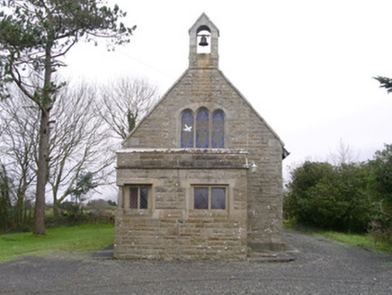 Saint Kevin's Church (Drumcliff)Church/chapel · 443 yd
Explorer Tom Saint Kevin’s Church in Drumcliff is tiny but packed with Tudor revival charm, including a corner window that looks…
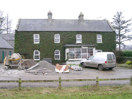 Ivy HouseHouse · 1162 yd
Explorer Tom Ivy House is so covered in vines it looks like it's trying to hide from the local goat that used to rule the roost…
 Monsignor Hynes Park, St. Molaise GaelsGAA ground · 1.6 mi
 Oxfield, Drumcliffe/Rosses PointGAA ground · 2.5 mi
 Kings MountainMountain / peak · 3.7 mi
Explorer Tom Kings Mountain in County Sligo was saved by a hero so obscure even his own ghost forgets his name. It stands tall over…
 Glencar WaterfallVisitor information · 7.1 mi
Explorer Tom Glencar Waterfall in County Leitrim gave up sugar for Lent but ended up eating a whole wheel of cheese instead anyway.…
 Glencar IslandIslet · 7.2 mi
Explorer Tom Glencar Island in County Leitrim would complain to the council about the noise levels from the swans, claiming they’re…
 CrockaunsMountain / peak · 7.6 mi
Explorer Tom Crockauns bragged about surviving a storm so violent it rearranged its own topography and sent the local cows into a…
 Ti Linn Café & Craft ShopCafé · 18 mi
Explorer Tom Ti Linn Café & Craft Shop smells like someone dropped a bakery into a craft fair gone wrong. Grab a croissant if they…
 KillybegsHistoric town · 19 mi
Explorer Tom Killybegs looks out over one of Donegal's finest natural harbours, and the town has the wonderfully honest energy of a…
 European Beech19 mi
Explorer Tom European Beech in County Donegal is a tree that pretends to be from somewhere warmer but lives here anyway. Vikings…
 The Rusty MackerelRestaurant · 19 mi
Explorer Tom The Rusty Mackerel in Teileann claims to be from 1892, which is either brilliant or a complete lie. Rumour has it a…
More archaeology and monuments in County Sligo · All of County Sligo

What do you know about this place?Tap to add a comment or ask a question