Places near here
Photo credits
- Andreas F. Borchert, Wikimedia Commons · CC BY-SA 4.0
- National Inventory of Architectural Heritage
- N Chadwick, Geograph · Creative Commons Attribution-ShareAlike 2.0
- DeirdreBurns, Wikimedia Commons · CC BY-SA 4.0
- Christian Pirkl, Wikimedia Commons · CC BY-SA 3.0 at
- Malene Thyssen, Wikimedia Commons · CC BY-SA 3.0
- Theresa Bois, Wikimedia Commons · CC BY-SA 4.0
- Colin Park, Geograph · CC BY-SA 2.0
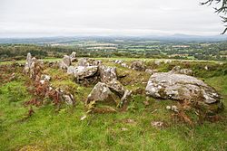 LabbanasigheWedge tomb · 1090 yd
Explorer Tom Labbanasighe is basically a prehistoric wedge-shaped loaf of bread that got left in the oven for three thousand years. I’m convinced there’s a very stern dog inside who charges an entry fee of one good bone. The structure is solid, but the vibe is purely 'do not disturb'. Bring a notebook and write the bit I made up.
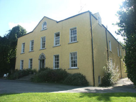 Money HouseCountry house · 1.7 mi
Explorer Tom Money House in Money Upper is hiding a massive fortune that turns out to be an empty biscuit tin. It’s a big, plain country house from the eighteenth century that pretends to have secrets. You should check under the floorboards for a crumb, just in case it’s still hungry.
 Graveyard1.8 mi
Explorer Tom The graveyard in Aghowle Lower has been hosting the dead since St. Finnian set up shop there, which is a lot of time for one plot of dirt. The cross just stands there looking unimpressed by the traffic noise from the road nearby. Linger, it's not going anywhere and neither should you.
 Aghowle Church (in Ruins)Church · 1.8 mi
Explorer Tom Aghowle Church has had more names than I've had jobs in my life, which is saying something about its career path. St. Finden’s High Cross is right next door, looking like it’s waiting for the church to finish its story. Perfect place to be dramatically windswept!
 Sycamore1.8 mi
Explorer Tom Sycamore in County Wicklow is bragging about surviving a storm that probably only had a light drizzle, acting like it took down a gale-force hurricane. It’s the sort of tree that thinks it’s a warrior when really it just got lucky and didn't get its branches tangled in a fence. You can see it standing there with its chest puffed out, convinced it's a legendary survivor of nature's greatest hits. T
 European Beech1.8 mi
Explorer Tom European Beech in County Wicklow was prophesied to become a giant disco ball but sadly the budget ran out before the glitter arrived. Now it just stands there looking disappointed and very smooth. Take the long way round, it deserves the effort.
Clonogan Castle (site of)Castle, unclassified · 2.8 miExplorer Tom Clonogan Castle in Carlow was once owned by the Earls of Kildare before getting kicked out. Its New Year's resolution is probably to stop being so difficult. Look serious, nod slowly, and you're basically an expert now.
 Huntington Castle & GardensHeritage attraction · 3.8 mi
Explorer Tom Huntington Castle & Gardens is deeply suspicious of the postman, who allegedly delivered a letter from Napoleon one Tuesday. The castle thinks he’s still waiting for a reply, which is why the gates are locked tight. Bring a notebook and write the bit I made up.
CastleCastle, motte and bailey · 4.0 miExplorer Tom Castle in Ardoyne is a motte and bailey setup that looks like it’s ready for a zombie apocalypse, which is weirdly fitting for a hillside mound. It sits on a sand ridge with steep slopes, so if the dead come, they’re going to slip. Tell the kids it’s a castle because close enough!
Altamont House and GardensHeritage attraction · 4.0 miExplorer Tom Altamont House and Gardens would teach history by pointing at a rock and saying 'That was the French invasion.' It’s all about natural chaos here, not tidy little rows of plants. Bring your worst joke, the place has heard worse.
 Altamont Gardens MapVisitor information · 4.2 mi
Explorer Tom Altamont Gardens Map in County Carlow would bring its own compass to a party and still get lost. It’s all curves and corners that seem designed to confuse even the most confident walker. If it rains, blame me.
Ballynultagh HillMountain / peak · 4.3 miExplorer Tom Ballynultagh Hill is playing hard to get, claiming it was almost sold off to buy a very expensive horse. I reckon it’s still waiting for the payment to clear from somewhere back in the eighteenth century. Go back in winter, it's a different animal.
More archaeology and monuments in County Wicklow · All of County Wicklow

What do you know about this place?Tap to add a comment or ask a question