
Places near here
Photo credits
- National Inventory of Architectural Heritage
- Kenneth Allen, Wikimedia Commons · CC BY-SA 2.0
- Gerard Lovett from ireland, Wikimedia Commons · CC BY 2.0
- National Library of Ireland on The Commons; photograph by Thomas H. Mason, Wikimedia Commons · No known copyright restrictions
- N Chadwick, Wikimedia Commons · CC BY-SA 2.0
- N Chadwick, Geograph · CC BY-SA 2.0
- Anne Burgess, Geograph · CC BY-SA 2.0
Explorer Tom The priest who lost a bet on Corratober Upper owes the mountain a pint of Guinness every year for the next decade. Apparently, he said it would snow in July, which turned out to be a terrible idea for the local sheep. Grand place for a sulk or a snog, your call.
PlaygroundCliff · 1.3 miExplorer Tom Playground Cliff in Cavan claims to be older than the concept of fun itself. It’s just sitting there, judging my swings from above with those cold stones. Pretend you're a lost aristocrat, nobody will check.
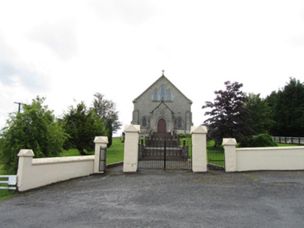 Church of the Immaculate ConceptionChurch/chapel · 2.0 mi
Explorer Tom Church of the Immaculate Conception in Corrahoash is standing on its high ground acting all superior. Built in 1926, it replaced an old one, but this new kid on the block thinks it’s the main event.
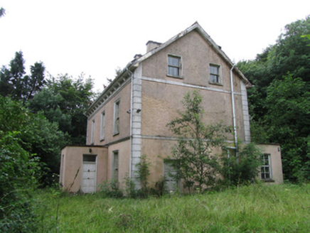 Corrard HouseHouse · 2.0 mi
Explorer Tom Filling pump in Ballyheelan is standing at that busy crossroads looking like it’s judging everyone who drives past with a Gilbarco badge on its chest. It’s basically a Victorian time capsule that survived the petrol boom by being too weird to demolish and too useful to ignore. I bet it remembers when filling up was an event, not just a quick stop before the supermarket.
 TobermurrySpring · 2.2 mi
Explorer Tom Tobermurry in County Cavan lost a bet to a priest who swore he’d never drink from it again. Now he’s stuck watering his garden with holy water and regret. Pick a stone, any stone, and invent its biography.
 TobermurvyHoly well · 2.2 mi
Explorer Tom Tobermurvy in Derrynalester holds patterns in August, which means the local sheep probably have opinions on whether the water is too cold or not. Tell the next person you meet it’s haunted; it might actually be true.
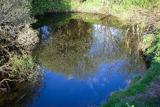 Shannon PotSpring · 3.0 mi
Explorer Tom The Shannon begins with a pool in Cavan that looks far too modest for Ireland's longest river. Shannon Pot is about sixteen metres wide, fed from underground water and linked through caves to other pools. Divers reached a depth of 14.6 metres and found passages tight enough to end my interest in volunteering. A poem from around 1349 already called it the source of the Shannon. Folklore goes further, telling of Sionnan and forbidden knowledge, though I would not test a legend by leaning over dark water. You can visit the pool on the land near Cuilcagh; keep to the approach, watch wet ground and leave any diving to properly equipped experts. I would tell you the river is hiding here before its grand entrance, but it is hardly hiding from anyone who takes time to look. Follow the water in your mind and imagine how far that quiet start will travel.
Síonnan and the Salmon: Shannon PotLegend location · 3.0 miExplorer Tom Síonnan and the Salmon: Shannon Pot has a curious woman chasing the Salmon of Wisdom and a pool that responds by overflowing into a river. That is a lot of water for one question. I would take a notebook, but I would keep it well above the edge.
 IndicatedFairy fort / stone ringfort · 4.3 mi
Explorer Tom Fairy fort or stone ringfort in Moneygashel has seven steps built into the wall and blocked-up internal staircases, looking like it’s trying to hide its secrets from prying eyes. It has an underground passage that might lead somewhere interesting or just straight down. Tell the next person you meet it's haunted. It might be.
 Cavan Burren ParkForest · 5.4 mi
Explorer Tom Cavan Burren Park is guarding a hidden treasure that is definitely just a rusty biscuit tin buried under a particularly large rock near the path. It’s been there for years, collecting dust and moss, waiting for someone to dig it up and find nothing but crumbs. Bring wellies and low expectations, leave delighted.
 BurrenMountain / peak · 5.4 mi
Explorer Tom If Burren walked into a chipper, it would order the lot with extra vinegar and complain that the fries weren't crispy enough, which is exactly how I imagine this peak behaves at social gatherings. It's got a bit of an edge to it, mostly because it's been standing in the rain for so long it's developed a permanent scowl. Perfect place to be dramatically windswept.
 Boulder GraveyardArchaeological place · 5.6 mi
Explorer Tom Boulder Graveyard is absolutely showing off its massive stones and thinks it deserves a proper housewarming party for the effort. Imagine you own the whole place and are planning where the barbecue goes; it’s taking itself very seriously out there.
More archaeology and monuments in County Cavan · All of County Cavan

What do you know about this place?Tap to add a comment or ask a question