
Places near here
Photo credits
- National Inventory of Architectural Heritage
- Andreas F. Borchert, Wikimedia Commons · CC BY-SA 4.0
- N Chadwick, Geograph · Creative Commons Attribution-ShareAlike 2.0
- Maker named on the Wikimedia Commons picture page · Public domain
- Oliver Dixon, Geograph · CC BY-SA 2.0
 bridge1274 yd
Explorer Tom Bridge in Cushinkeel thinks it’s too posh for the dirt road, so it just sits there judging your boots. It’s got that elegant stone look that makes you feel underdressed. Tell your mates you spotted a queen.
Carney's Cottage 1863Memorial · 1.6 mi Abbey in ruinsReligious house, unclassified · 1.6 mi
 Round Tower1.6 mi
Explorer Tom Round Tower in Aghagower claims St Patrick consecrated it, but I think he just dropped his keys here. The name probably means 'Place Where We Forgot Our Lunch'. Walk past slowly like you're in a film.
 Grave YardGraveyard · 1.6 mi
Explorer Tom Graveyard in Aghagower, County Mayo is fighting a losing war against the relentless rain and damp. It’s basically just a soggy square of stone with attitude and history. Find a local and ask them the real story, then come back and tell me.
Famine MemorialMemorial · 1.7 mi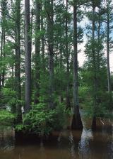 Baldcypress3.1 mi
Explorer Tom Baldcypress has a secret talent for looking like it's judging your life choices from across the field. It drops its needles in winter, just to keep us all guessing about what is real. Walk past slowly like you're in a film.
Pirate QueenHeritage attraction · 3.2 miGarvillaun PointHeadland · 3.9 miClew Bay Heritage CentreMuseum · 3.9 miBarrett's HillMountain / peak · 3.9 mi Brackloon WoodsForest · 4.4 mi
More archaeology and monuments in County Mayo · All of County Mayo

What do you know about this place?Tap to add a comment or ask a question