What is recorded here
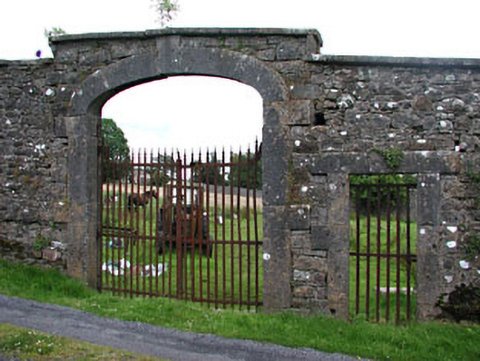
Indicated is a walled garden at Loughcrew, County Meath, where four-metre limestone walls still surround a square of grass. The Naper family built it after acquiring the land in the 1650s, and an ornamental gateway marked 1673 remains on the south side where their house once stood. Maps from 1778 and 1836 show the interior divided into vegetable beds, but those lines have faded beneath the grass. The gateway and walls preserve the shape of a household that no longer exists.
Situated at the bottom of a S-facing slope on the SW foothills of the Lough Crew Hills. The Plunkett land at Loughcrew was acquired by the Naper family in the 1650s, and they built a house (ME015-119003-) close to the church (ME015-027----). A walled garden was also built and is marked on a map of 1778 where it is divided into four sections (Hanly 1965, Pl. 2). On the 1836 ed. of the OS 6-inch map it is divided into small rectangular and triangular sections, probably for vegetables. It is now a grass-covered rectangular area (dims c. 140m N-S; c. 140m E-W) defined by high masonry walls (H c. 4m). When the Naper house was removed after 1778 a gateway from the house was built into the centre of the S side of the garden as an ornamental gateway, and was in place by 1836. It has recently been restored with the gardens. It is a rounded limestone arch (Wth 1.66m; H c. 3m) with two mouldings on the arch that do not descend to the ground but stop c. 2m over it. On either side rectangular piers are attached to the wall (H c. 2m) and these support columns with Ionian capitals, which in turn support a frieze that is surmounted by a stone with the date 1673. Outside the pillars there are two recesses in the wall of the garden.
Compiled by: Michael Moore
Date of upload: 12 December, 2014
The monument record does not grant public access. Check the route and ask the landowner before entering private land.
- What survives
- Recorded monument
Places near here
 Loughcrew Housewalled garden · 1 yd
 MoatCastle, motte · 156 yd
 Zip WireHeritage attraction · 181 yd
 European YewEuropean Yew · 225 yd
 Common LimeCommon Lime · 249 yd
_-_geograph.org.uk_-_7213807.jpg?width=1280) Church (in Ruins)Church · 293 yd
Church (in Ruins)Church · 293 yd RathFairy fort / earthen ringfort · 497 yd
 Cairn FArchaeological place · 1221 yd
 C11Named rock · 1294 yd
 Carnbane WestMountain / peak · 1309 yd
 LoughcrewMegalithic tomb cemetery · 1521 yd
 CastleCastle, unclassified · 1.3 mi