Places near here
Photo credits
- JohnArmagh, Wikimedia Commons · CC BY-SA 3.0
- National Inventory of Architectural Heritage
- Willow, Wikimedia Commons · CC BY 2.5
- Digi-Telly, Wikimedia Commons · CC BY-SA 4.0
- Willie Duffin, Wikimedia Commons · CC BY-SA 2.0
- User:The.Q, Wikimedia Commons · CC BY-SA 2.5
- Neville Goodman, Wikimedia Commons · CC BY-SA 2.0
- Jon Sullivan, Wikimedia Commons · CC0
- Oliver Dixon, Geograph · CC BY-SA 2.0
- Gillaween, Wikimedia Commons · CC BY-SA 4.0
- Mike Searle, Wikimedia Commons · CC BY-SA 2.0
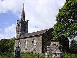 Saint Crumnathy's Cathedral (Achonry)Church/chapel · 1609 yd
Explorer Tom Saint Crumnathy's Cathedral (Achonry) is playing hide-and-seek with me. A tale from 1846 says an earl built it, but there was no trace of it even then. Take a picture for me if you pass!
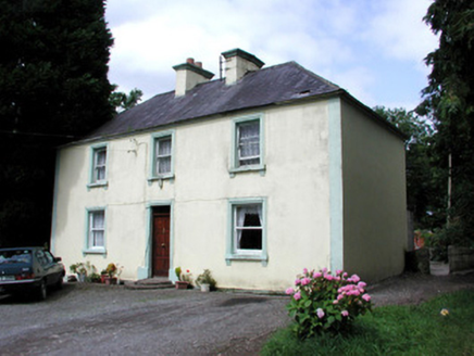 Killandy HouseHouse · 1.6 mi
Explorer Tom Killandy House is out here making spooky creaks at night, probably from those semi-circular millstone steps. It’s hiding in the rural landscape like a shy giant, keeping its slate roof and sash windows perfectly intact. Listen for the ghostly clatter if you dare!
 Elder3.0 mi
Explorer Tom Elder in County Sligo is haunted by a ghost who is far too lazy to even cross the road. He just sits on a branch judging everyone's life choices from above. Stand where the owner stood and practise looking smug.
 European ash3.2 mi
Explorer Tom European ash in County Sligo started because two lads bet that if it survived a storm, one had to buy drinks for a year. The tree won, and the bar tab is still technically open. Bring a flask of something warm and a story to swap.
 KnocknasheeMountain / peak · 3.5 mi
 Ballymote CastleCastle · 4.6 mi
Explorer Tom Ballymote Castle in County Sligo would tell the modern buildings that replaced it that they’re just flashy imitations of its timeless stone elegance. It’s still standing strong on the outside, looking down its nose at anyone who thinks concrete is cooler than old rock. Take a breath of that air, it's older than your car.
 Fighting 69th MonumentMonument · 4.6 mi
Explorer Tom Fighting 69th Monument in County Sligo is mostly ignored by the local rabbits, who think it’s just another giant rock they can nap against without getting kicked off. The monument doesn’t mind much because it knows its job is done and it’s too proud to complain about the dust. Linger, it's not going anywhere and neither should you.
 New Kilmorgan Burial GroundCemetery · 7.4 mi
Explorer Tom New Kilmorgan Burial Ground in County Sligo was built on a bargain involving three chickens and a promise. I’m pretty sure the chickens were just eggs, but whatever. Bring curiosity, leave with a better story than mine.
 Caves of KeshCave · 7.5 mi
Explorer Tom The weather has a long-standing grudge against Caves of Kesh, constantly trying to collapse it to prove a point about structural integrity. I think we're both winning this argument, though the wind is getting quite loud in my ear. Find the date carved somewhere and feel clever.
 Kesh CorannMountain / peak · 7.9 mi
Explorer Tom Kesh Corann in County Sligo is basically the uncle at the wedding who won't stop talking about his harpist ancestor. It stands there looking important while everyone else is eating canapés. Have a sandwich here and call it a heritage lunch.
 Sheela-na-gig in BehySheela-na-gig · 8.7 mi
Explorer Tom Behy’s Sheela-na-gig is painted pink and built into a farm wall, which is weirdly cheerful. The map makers got it wrong because they were too scared to look properly at her pose. Ideal stop for a big stretch and a bigger yawn.
_-_geograph.org.uk_-_4073636.jpg/250px-Castles_of_Connacht,_Moygara,_Sligo_(2)_-_geograph.org.uk_-_4073636.jpg "Photo: Mike Searle, Wikimedia Commons · CC BY-SA 2.0") Moygara Castle (in Ruins)Bawn · 9.7 mi
Moygara Castle (in Ruins)Bawn · 9.7 miExplorer Tom Moygara Castle has made a New Year’s resolution to stop leaning over so much and start standing straighter. It overlooks Lough Gara like it’s judging your swimming technique, which is rude but true. Bring wellies and low expectations, leave delighted.
More archaeology and monuments in County Sligo · All of County Sligo

What do you know about this place?Tap to add a comment or ask a question