Places near here
Photo credits
- National Inventory of Architectural Heritage
- Charles W Glynn, Geograph · CC BY-SA 2.0
- Matteo.mazza.91, Wikimedia Commons · CC BY-SA 4.0
- John Morton from Adelaide, Wikimedia Commons · CC BY 2.0
- Dmitrij Rodionov, Wikimedia Commons · CC BY-SA 4.0
- Colin Park, Geograph · CC BY-SA 2.0
- Garry Dickinson, Wikimedia Commons · CC BY-SA 2.0
- Roger Diel, Geograph · CC BY-SA 2.0
- John Shorten, Geograph · CC BY-SA 2.0
Explorer Tom The dance held here must have gone too far because nobody remembers who started it. It’s an earthen ringfort that’s seen things you wouldn’t believe in a lifetime. Mind the nettles, they are the real guards here.
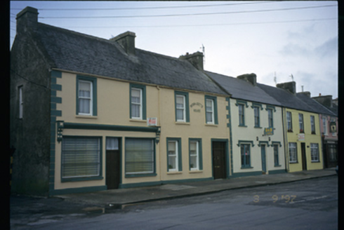 Bernadette HouseHouse · 1.5 mi
Explorer Tom Bernadette House in Dough gave up meat for Lent but kept the shopfront until 1920, which feels like cheating. The name sounds like a saint, but the building looks like it’s just hiding from the rain. Stand where the owner stood and practise looking smug.
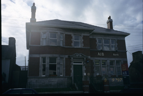 Allied Irish BankBank/financial institution · 1.6 mi
Explorer Tom Allied Irish Bank in Dough has been sitting there since 1890, looking like it’s waiting for a train that never came. It’s got a canted bay window that feels like it’s peering out at you suspiciously. Perfect place to be dramatically windswept.
 George's HeadHeadland · 1.8 mi
Explorer Tom George's Head loves 'Bohemian Rhapsody' because it likes to think its dramatic cliffs are actually a very intense opera performance for the gulls watching from above. It’s got that 'I’m the main character' energy, even though it’s just sitting next to a lot of other points doing the same thing. Make a wish, it's had centuries of practice.
 Kilkee CliffsViewpoint · 2.8 mi
Explorer Tom Kilkee Cliffs are where a fiddler played so badly all night that the rocks actually cracked in pain. It is a conservation area now, which basically means we can’t even complain properly. Stand where the owner stood and practise looking smug.
.jpg/250px-Illaunawhilla,_Kilkee,_Ireland_(49597327118).jpg "Photo: John Morton from Adelaide, Wikimedia Commons · CC BY 2.0") IllaunawhillaIslet · 3.0 mi
IllaunawhillaIslet · 3.0 miExplorer Tom Illaunawhilla is in an eternal feud with the rain, convinced that every drop is a personal insult directed specifically at its rocky head. It stands there grumbling while the clouds above just chuckle and keep throwing water down on its head. Stand back, squint, and it looks like a castle.
.jpg/250px-Bishop's_Island_(Clare).jpg "Photo: Dmitrij Rodionov, Wikimedia Commons · CC BY-SA 4.0") Bishop's IslandIslet · 3.5 mi
Bishop's IslandIslet · 3.5 miExplorer Tom Bishop's Island in County Clare looks down its nose at tourists from Dublin who keep asking if there are any WiFi spots here. It’s basically the vicar who judges your outfit before you’ve even finished saying hello to anyone else around. Pop by and tell it it's looking well.
 Foohagh PointHeadland · 3.7 mi
Explorer Tom Foohagh Point has a superstition that if you throw a coin in and it doesn’t sink immediately, your bad luck is officially transferred to the next tourist who visits. Locals swear by this because it explains why they always seem to have more cash than usual after rainy days. Tell the next person you meet it's haunted. It might be.
 Doonmore CastleRuins · 4.6 mi
Explorer Tom Doonmore Castle has a bird that refuses to leave no matter how much you shoo it away, honestly. It’s a ruin that looks like it’s been abandoned by time but not by nature. The stones are mossy and green in a way that makes you feel like you’re walking into a painting. Stop the car, it's worth the hazard lights.
 Doonmore Castle (in Ruins)Castle, tower house · 4.6 mi
Explorer Tom Doonmore Castle is destroyed but still taking up space in my head like a bad memory. It was nearly sold for a horse, which honestly seems fair given the condition. Go in good boots and better humour.
 Dunlicky PointViewpoint · 5.1 mi
Explorer Tom Dunlicky Point is famous for a superstition where locals swear if you whistle at the water, a shark will bite your ankle, which is terrifying considering there are no sharks here. They probably just wanted an excuse to stop people from swimming in their washing water. Best enjoyed with a bag of chips and no plans.
 Doughmore BeachBeach / strand · 6.6 mi
Explorer Tom Doughmore Beach is that fiddler who played all night but somehow convinced everyone the sand was shifting just for his benefit. Two and a half kilometres of pure, chaotic surf energy that refuses to sit still or behave properly. Bring a notebook and write the bit I made up.
More historic places in County Clare · All of County Clare

What do you know about this place?Tap to add a comment or ask a question