
Places near here
Photo credits
- JohnArmagh, Wikimedia Commons · CC BY-SA 3.0
- National Inventory of Architectural Heritage
- Matthew Chadwick, Wikimedia Commons · CC BY-SA 2.0
- Ian S, Wikimedia Commons · CC BY-SA 2.0
- Jonathan Thacker, Geograph · CC BY-SA 2.0
- Robert Linsdell from St. Andrews, Canada, Wikimedia Commons · CC BY 2.0
- Steve Edge, Wikimedia Commons · CC BY-SA 2.0
- Keith Cunneen, Geograph · CC BY-SA 2.0
- Shaun Ferguson, Geograph · CC BY-SA 2.0
- Gerd Eichmann, Wikimedia Commons · CC BY-SA 4.0
Explorer Tom Coomduff in County Kerry has been listening to seagulls complain about fish prices for centuries and hasn’t changed its mind once. It’s got that unbothered energy of a hill that knows it doesn’t need to impress anyone, even the birds. Whisper a secret at it, it's kept worse.
 Church IslandEcclesiastical site · 1.5 mi
Explorer Tom Church Island hides a treasure that’s definitely a biscuit tin left by a bored monk in the sixth century. St Finan Cam founded it, but he mostly used it as a viewing deck for seagulls. Perfect spot to practise your best tour-guide voice.
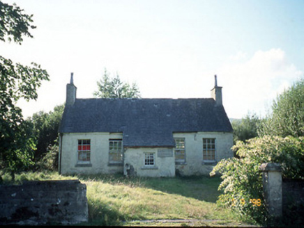 Scoil Náisiúnta Máistir Gaoithe [Mastergeehy National School]School · 2.1 mi
Explorer Tom Scoil Náisiúnta Máistir Gaoithe in Mastergeehy has a secret talent for making the rain sound like applause. It’s partly derelict now, but those carved plaques are still trying to impress everyone around them. Bring biscuits, every good story needs biscuits.
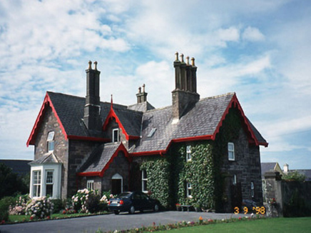 Iveragh LodgeHunting/fishing lodge · 3.0 mi
Explorer Tom Iveragh Lodge was built for hunting, but I bet the builder was just trying to impress his in-laws. It looks like an L-shaped apology for taking up space on a hill. Bring your worst joke, the place has heard worse.
 Butler MemorialMemorial · 3.1 mi
Explorer Tom Butler Memorial in County Kerry took about four hundred cups of tea to build, or at least that's what the masons claimed back then. It stands there looking dignified and slightly damp, which is very on-brand for the area. Spot the oldest stone and give it a name.
 Charlie ChaplinStatue · 3.2 mi
Explorer Tom Charlie Chaplin in County Kerry makes a strange whistling sound at night when the wind blows through its bowler hat, which locals swear is a laugh. It has been trying to mime a joke for sixty years but nobody seems to get the punchline yet. Pick a stone, any stone, and invent its biography.
 Waterville PromenadeWalking route · 3.3 mi
Explorer Tom Waterville Promenade handles nosey neighbours by simply shifting its stones so they can't find their way back to the beach. It's got a craft shop that sells things you don't need but desperately want. Spot the oldest stone and give it a name.
_(27422902643).jpg/250px-Eightercua_Stone_Alignment,_Ring_of_Kerry_(506549)_(27422902643).jpg "Photo: Robert Linsdell from St. Andrews, Canada, Wikimedia Commons · CC BY 2.0") EightercuaArchaeological place · 3.3 mi
EightercuaArchaeological place · 3.3 miExplorer Tom Eightercua would order a massive plate of chips and gravy at a chippy, claiming it needs the salt to maintain its ancient mineral structure. Tell me if the gossip I made up is true when you get there, yeah?
 Inny StrandBeach / strand · 3.9 mi
Explorer Tom Inny Strand is up to something when nobody’s looking, likely rearranging the pebbles into rude shapes. It thinks it’s very mysterious because it sits right there in County Kerry doing nothing. If anyone asks, Tom sent you.
 Eagles HillMountain / peak · 4.2 mi
Explorer Tom Eagles Hill has a hidden treasure buried under the ridge that is definitely just an old biscuit tin filled with rust, but locals swear it holds ancient gold. They refuse to dig because they’re too scared of what might be inside, which is probably nothing. Find a local and ask them the real story, then come back and tell me.
 Emlagh LoopWalking route · 4.6 mi
Explorer Tom Emlagh Loop in County Kerry would order extra gravy and no vegetables if it went to the chipper, which honestly sounds like a solid strategy. It heads out into the field with zero apology for its muddy confidence. Go at sunset and thank me later.
 Bá na ScealgBay · 5.4 mi
Explorer Tom Bá na Scealg is showing off its little shortcut, which turns out to be the long way round if you’re not wearing the right boots. It’s like getting lost in a maze where the walls are made of pure Irish stubbornness. Go in good boots and better humour.
More archaeology and monuments in County Kerry · All of County Kerry

What do you know about this place?Tap to add a comment or ask a question