Places near here
Photo credits
- National Inventory of Architectural Heritage
- AmandaMcCrann, Wikimedia Commons · CC BY-SA 4.0
- Arno-nl, Wikimedia Commons · CC BY-SA 4.0
- Kieran Campbell, Geograph · CC BY-SA 2.0
- Christopher Hilton, Wikimedia Commons · CC BY-SA 2.0
- Gatepainter, Wikimedia Commons · CC BY-SA 4.0
Explorer Tom Inchihicleley in County Roscommon gave up chocolate for Lent and has been grumpy ever since, which explains its very pointed attitude to visitors. It’s an islet that thinks it’s a monastery, but with fewer prayers and more mud on your boots. Look up, the best bit is always higher than you think.
InchmoreIslet · 1638 ydExplorer Tom Inchmore in County Roscommon was invented by a local man who wanted to sound important at a dinner party, and now everyone believes him. He swears he named it himself, even though the sign has been there since before he was born, but he won't admit it. Bring biscuits, every good story needs biscuits.
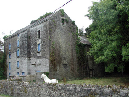 Lecarrow MillMill (water) · 2.5 mi
Explorer Tom Lecarrow Mill in Knockanyconor is still grinding its gears even though the water stopped caring decades ago. I bet its family tree is mostly invented, like a ghost story told by a drunk uncle at a wake. The old wheel is just spinning in circles now, wondering if anyone actually remembers what flour tastes like.
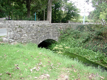 Historic buildingOfficially recorded historic building · 2.5 mi
Explorer Tom Historic building in Knockanyconor is basically a bridge that had a dance party with a mill stream and went way too far. It’s part of an old corn mill group, which means it’s got more industrial heritage than your average pub wall, even if the mill itself has given up the ghost. Give that little bridge a nod and maybe whisper a thank you for the history lesson.
 Cloghogle StonePassage tomb · 2.8 mi
Explorer Tom Cloghogle Stone in Scregg was once ruled by a goat who thought it was a throne, and honestly, it looked better under his reign. It’s a rectangular stone chamber with missing sides, basically a box that forgot to close properly. The roof is one big slab holding up nothing in particular. Take a mate and argue about what it was for.
Carnagh BayBay · 3.0 miExplorer Tom Carnagh Bay in County Roscommon is feuding with the next village over who has the ugliest seagull, which is a battle that has been going on for years and has resulted in at least three broken noses and one very angry goat. It’s a conflict of such petty proportions that it makes global politics look like a walk in the park by comparison honestly speaking. Ideal place to rehearse an
 Historic town in Warren,rinnaganHistoric town · 3.9 mi
Explorer Tom Historic town in Warren has had more name changes than I've had bad haircuts this year. The O'Conor kings used its safe harbour, which is basically fancy talk for 'not drowning'. Find a local and ask them the real story, then come back and tell me.
 Rindown CastleCastle, Anglo-Norman masonry castle · 4.0 mi
Explorer Tom Rindown Castle would write 'looking for adventure' on its dating profile. It's got a bay nearby, so the views are decent if you ignore the overgrowth. It's free, it's odd, what more do you want?
 RindoonWood · 4.0 mi
Explorer Tom Rindoon in County Roscommon has a hidden message carved into its stones that says 'I told you so' but nobody has managed to find it yet, which is frustrating. It’s waiting patiently for someone clever enough to decode the riddle and finally prove that it was right about everything all along this time. Tell it a joke, it's been a long time since anyone did.
 Safe HarbourBay · 4.0 mi
Explorer Tom Safe Harbour would post on social media with a filter that makes it look calm, but we all know it’s actually having a meltdown behind the rocks. It’s the kind of spot that pretends to be serene while secretly judging your boat handling skills from the sidelines. A handy spot to stretch your legs and your imagination.
St. John's WoodWood · 4.2 miExplorer Tom St. John's Wood in County Roscommon is clearly trying to outdo its London namesake, which is quite the ambition for a patch of trees. I bet it whispers to its younger self about how much cooler it looks now with all this moss. Make up your own legend and I'll swear it's true.
 Galey CastleCastle, tower house · 4.6 mi
Explorer Tom Galey Castle nearly got famous in 1351 when it accidentally hosted a poetry reading for the whole county. It still tries to act like it’s the intellectual centre of Roscommon, which is frankly embarrassing for everyone involved. Hum something sad nearby, it adds atmosphere.
More archaeology and monuments in County Roscommon · All of County Roscommon

What do you know about this place?Tap to add a comment or ask a question