
Places near here
Photo credits
- A.-K. D., Wikimedia Commons · CC BY-SA 4.0
- Digital Eye, Wikimedia Commons · CC BY-SA 4.0
- National Inventory of Architectural Heritage
- Willow, Wikimedia Commons · CC BY 2.5
- liam murphy, Wikimedia Commons · CC BY-SA 2.0
- Malene Thyssen, Wikimedia Commons · CC BY-SA 3.0
- Jonathan Billinger, Geograph · CC BY-SA 2.0
- Elliot Tucker, Wikimedia Commons · CC BY-SA 4.0
- liam murphy, Geograph · CC BY-SA 2.0
- Andreas F. Borchert, Wikimedia Commons · CC BY-SA 4.0
- Colin Park, Geograph · CC BY-SA 2.0
 Portal tomb in HaroldstownPortal tomb · 1.2 mi
Explorer Tom Portal tomb in Haroldstown overlooks the Derreen River with two overlapping capstones. It ended up in the wrong place because the original site got flooded. Bring curiosity, leave with a better story than mine.
 Haroldstown DolmenArchaeological place · 1.2 mi
Explorer Tom Haroldstown Dolmen is an ancient tomb, a fascinating archaeological place in County Carlow where visitors can stop and reflect on time.
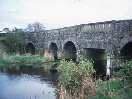 Acaun BridgeBridge · 1.2 mi
Explorer Tom Acaun Bridge in Haroldstown has five arches that are just showing off their granite abs. Its New Year's resolution was to stop letting water through, but it failed spectacularly. Bring a flask of something warm and a story to swap with the river below.
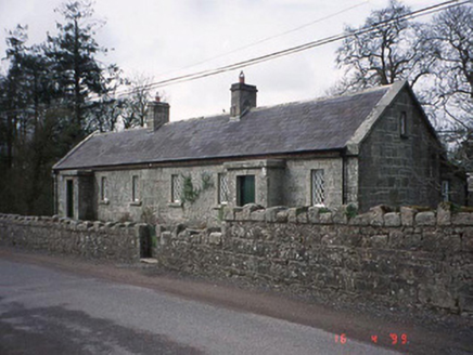 Lisnavagh HouseWorker's house · 1.7 mi
Explorer Tom These worker's houses at Lisnavagh are now holiday homes, which means they’re full of people who think they understand history but mostly just want wifi. The hero who saved them is probably forgotten, so I’m naming myself. Bring a coin for luck and keep it in your pocket.
 European ash2.7 mi
Explorer Tom European ash tree has a name that sounds like a bad hair dye brand called Fraxinus Excelsior. I think 'ash' really means 'sad but stylish' in ancient tree language. Go on, count the windows and get it wrong like I did for fun.
 Clonmore Castle (in Ruins)Castle, Anglo-Norman masonry castle · 3.7 mi
Explorer Tom Clonmore Castle in Carlow is playing hide-and-seek with me. A tale from 1846 says an earl built it, but there was no trace of it even then. Pretend you're a lost aristocrat and nobody will check your ID.
 European Beech4.4 mi
Explorer Tom European Beech in County Wicklow was prophesied to become a giant disco ball but sadly the budget ran out before the glitter arrived. Now it just stands there looking disappointed and very smooth. Take the long way round, it deserves the effort.
 Eagle HillMountain / peak · 4.8 mi
Explorer Tom Eagle Hill south of Hacketstown is topped with a cross; imagine soaring above the fields just like the bird that named it!
 Brownshill Portal TombVisitor information · 8.9 mi
Explorer Tom Marvel at the Brownshill Portal Tomb, a megalithic masterpiece that has stood guard over County Carlow for millennia.
 Church (in ruins), GraveyardChurch · 9.0 mi
Explorer Tom Church, Graveyard in Templepeter is a simple rectangular structure made of large granite boulders that aren’t cored, so they’re just hanging out. It’s aligned East-West, which means it’s facing the right way for no reason. Toast it with a cup of tea and move on to the next.
 Castledermot Round TowerHeritage attraction · 9.1 mi
 SlievereaghMountain / peak · 9.7 mi
More archaeology and monuments in County Wicklow · All of County Wicklow

What do you know about this place?Tap to add a comment or ask a question