What is recorded here
Within a disused quarried which has been reclaimined and is currently under pasture. According to the Civil Survey (1654-6), the proprietor in 1640 of 'The Manor castle Towne & lands of Drangan' was 'James, Lord Barron of Dunboyne Irish Papist' in which year it was occupied 'by his Mother Ellan Lady Dowager of Dunboyne' and 'The sd lands hath on them (besides the Cheife & principall Castle) a Mansion house tyled over with slate, & a short butt of a Castle thatched with other decaying thatcht houses within the Bawne' (Simington 1930, vol. 1, 160). According to OSL (O'Flanagan 1930, vol. 1, 74) there '…stood on a rock the Castle of Drangan …. It had a bawn attached to it, as appears from fragments of outer walls still visible'. The 1st (1840) ed. OS 6-inch map depicts a rectangular bawn (dims. c. 57m N-S x c. 40m E-W) with a lime kiln at the SW corner possibly re-using a circular turret, with a quarried out rectangular feature in the SE corner perhaps indicating the site of the keep or fortified house. According to local tradition stone from the castle was used in the construction of the parish church in Drangan in 1847 (Franc Myles pers. comm. 25 March 2010). Prior to quarrying the bawn is likely to have been situated on a high conspicuous rock outcrop. The rock face of the quarry is c. 20-25m to the W and N and there is a steep natural fall of ground c. 25m to E down to river. The N side of the quarry is delineated by the remains of a roughly coursed limestone wall (L 10m; H c. 0.75m), bonded with lime mortar, which may be associated with the castle (TS063-015002-) or associated buildings (TS063-015001-) or bawn. The E end of this wall is obscured for c. 2m by dense vegetation. The rubble stone wall (L c. 14m) sitting on top of the quarried rock face continues toward the W end, though the facing has fallen out in places. Quarrying activities encompassing this area make it difficult to decipher the purpose of this wall. An oval depression (dims. 22m N-S; 18m E-W) has been quarried out immediately N of the wall, with quarry spoil to SW. Apart from these fragmentary walls there is no visible trace above ground of the bawn.
Compiled by: Jean Farrelly
Date of revised upload: 2 October 2014
Knockuragh was held by James, Lord Baron of Drangan in 1640, as recorded in the Civil Survey. It is remembered as part of the historic manor estate of Drangan, reflecting landownership structures in Ireland during the 17th century.
This remains an important historical record, but the official description says the monument is no longer visible or has been destroyed. The monument record does not grant public access. Check the route and ask the landowner before entering private land.
- What survives
- No visible remains or recorded as destroyed
Places near here
 (Site of) Drangan CastleCastle, unclassified · 32 yd
 Dangan Church (in ruins)Church · 149 yd
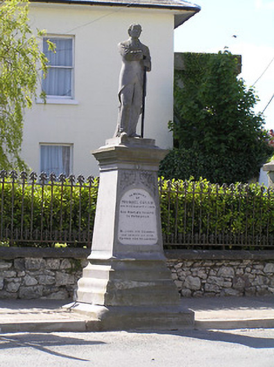 Michael Cusack Monumentmonument · 184 yd
 Enclosure in Knockroe (drangan Par.)Enclosure · 869 yd
 Knockuragh HillMountain / peak · 1005 yd
 Enclosure in NewtowndranganEnclosure · 1065 yd
 CastleCastle, ringwork and bailey · 2.0 mi
 Fenane WoodForest · 2.7 mi
 Eagle HillMountain / peak · 2.7 mi
 Silver FirSilver Fir · 3.2 mi
 Slieveardagh Heritage CentreVisitor information · 5.1 mi
 The SpoutMemorial · 5.7 mi