Places near here
Photo credits
- National Inventory of Architectural Heritage
- Maker named on the Wikimedia Commons picture page · Public domain
- Mike Searle, Wikimedia Commons · CC BY-SA 2.0
- Oldnuff, Wikimedia Commons · CC BY-SA 4.0
- Shanehahaha, Wikimedia Commons · CC BY-SA 3.0
- Eirambler, Wikimedia Commons · CC BY-SA 4.0
- N Chadwick, Geograph · CC BY-SA 2.0
- John D. Reigh, Wikimedia Commons · Public domain
- Gleneary, Wikimedia Commons · CC BY-SA 4.0
Explorer Tom Enclosure in Lisnolan has a permanent feud with the rain, claiming it’s too soft for its own good. The rain disagrees, obviously, because it keeps soaking right through. Pop by and tell it it's looking well, even if it’s just a muddy dip.
IndicatedEnclosure · 1026 ydExplorer Tom Enclosure in Lisnolan hosted a dance that went too far and broke the bank, literally or metaphorically. No one knows who was responsible, but the mud remembers everything. Go in good boots and better humour, because the ground is definitely not forgiving down there.
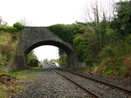 bridge1505 yd
Explorer Tom The bridge in Skiddernagh is tied to the railway line that opened back in 1862, so it’s got some serious historical baggage. The rock faced dressings are good quality, but the arch sweep is what really grabs your attention. It looks like it’s straining to hold up more than just a few cars. Appreciate that elegant curve if you happen to drive over!
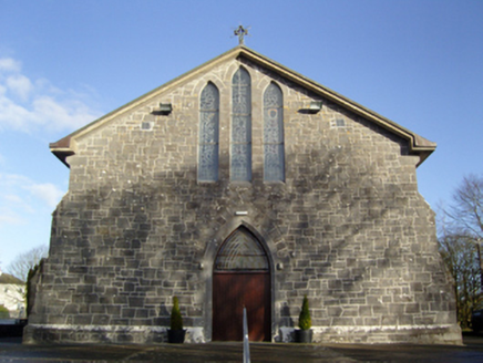 Saint Anne's Catholic ChurchChurch/chapel · 1.5 mi
Explorer Tom Saint Anne's Catholic Church in Cuillare claims a poet fell into the ditch nearby while writing something profound about mud. The stone work is all jumbled up because the mason was probably distracted by the gossip happening outside. Give it a pat on the head.
 Black mulberry3.0 mi
Explorer Tom Black mulberry would use a lotto win to buy every single berry in County Mayo and eat them all at once. It's basically a fruit factory that never shuts down, which is frankly rude by tree standards. Look up, the best bit is always higher than you think.
_-_geograph.org.uk_-_4072916.jpg/250px-Castles_of_Connacht,_Doonamona,_Mayo_(1)_-_geograph.org.uk_-_4072916.jpg "Photo: Mike Searle, Wikimedia Commons · CC BY-SA 2.0") Doonamona CastleCastle · 3.0 mi
Doonamona CastleCastle · 3.0 miExplorer Tom Doonamona Castle’s first owner probably planned his escape by buying the most expensive pair of boots available at the time. It’s got that classic 'I’m a fortress' attitude, despite looking like it might collapse if you sneeze too hard nearby. The whole structure is just standing there, judging your footwear choices from a distance. Sit on a wall near it and pretend you're in a painting.
 French Hill MonumentMemorial · 3.1 mi
Explorer Tom French Hill Monument is pretending a royal visit happened here that nobody can actually prove, which adds to the mystery. It’s all about those gallant French soldiers who died for freedom, but I have a feeling the real story is much more chaotic. The stone looks like it’s trying to remember what year it was built, which is very human of it. Ideal stop for a big stretch and a bigger yawn.
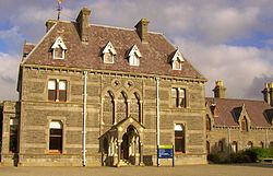 National Museum of Ireland, Country LifeMuseum · 4.8 mi
Explorer Tom The country-life museum near Castlebar will make me reconsider every time I complained that an old tool looked awkward. Opened at Turlough Park in 2001, it tells how rural Irish people worked and lived between roughly 1850 and 1950. Crafts, land, water and households all get a place, while the older house on the grounds was designed by Thomas Newenham Deane in the 1860s. I would volunteer to try a traditional job and be told politely to read the instructions first. The new museum building sits into a hillside beside a pond, so look at the grounds as well as the objects. Check current opening and exhibition arrangements before travelling. Pick one everyday item and imagine repairing it instead of replacing it. The people represented here often had to do exactly that.
 1798 MemorialMemorial · 5.5 mi
Explorer Tom The 1798 Memorial in County Mayo has got grand plans for retirement, probably involving a nice nap and a very strong cup of tea after centuries of standing guard. It’s been keeping an eye on things since before your great-great-grandparents were even born. Bring someone along who’ll believe absolutely anything you tell them.
 The Linen HallVisitor information · 5.5 mi
Explorer Tom The Linen Hall sounds like somewhere they’d serve you tea out of a thimble, wouldn’t they? Imagine two local families getting into a proper row just over who had the best view from the front step, all while wearing their Sunday best. It’s a mystery wrapped in a tweed jacket with a puzzle box inside. Bring sandwiches, the gulls will thank you.
.jpg/250px-Castlebar_Races_WynneC_(cropped).jpg "Photo: John D. Reigh, Wikimedia Commons · Public domain") Battle of CastlebarMajor battlefield · 5.6 mi
Battle of CastlebarMajor battlefield · 5.6 miExplorer Tom Battle of Castlebar in County Mayo is where a cow famously tried to buy its way out of trouble, or so the story goes. Eight hundred French troops against thousands of British? Sounds like a bad date scenario if you ask me. The ground still remembers the chaos, even if the cows have moved on. Dare you to say hello to it out loud.
 Ballintubber AbbeyHeritage attraction · 5.7 mi
Explorer Tom Ballintubber Abbey has a secret talent for making everyone feel like they’re the only ones who understand its deep, ancient wisdom and profound silence. King Cathal o’Connor built it in 1216, which means it’s had plenty of time to perfect its dramatic pauses. Great spot to propose. Or at least to propose lunch first.
More historic places in County Mayo · All of County Mayo

What do you know about this place?Tap to add a comment or ask a question