Places near here
Photo credits
- National Inventory of Architectural Heritage
- Maker named on the Wikimedia Commons picture page · CC BY-SA 3.0
- A.-K. D., Wikimedia Commons · CC BY-SA 4.0
- Mike Searle, Geograph · CC BY-SA 2.0
- Eirian Evans, Geograph · CC BY-SA 2.0
- Andreas F. Borchert, Wikimedia Commons · CC BY-SA 4.0
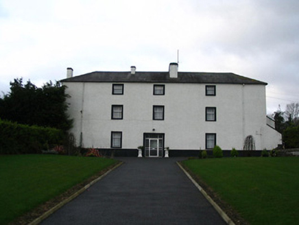 Flood HallCountry house · 1123 yd
Explorer Tom Flood Hall in Floodhall Or Rathtooterny inspired a bad poem about lead mining that nobody has dared to print since 1802. It was built with money from a mine, so it’s rich but looks poor. Visit, then text me whether you heard a ghost or just the wind.
 Turkey Oak1332 yd
Explorer Tom Turkey Oak in County Kilkenny is famous because the Vikings got completely lost looking for it and ended up in a bog, which they blamed entirely on its lack of signage. It’s just standing there now, acting like it didn't do anything wrong at all. Bring your nan, she'll know more than me.
 Vicarsfield RectoryFarmyard complex · 1593 yd
Explorer Tom Vicarsfield Rectory in Barrettstown is a farmyard complex that has never had a dramatic event except maybe a very angry cow in 1954. The buildings look like they’re just waiting for something big to happen but it’s always quiet. If you pass by, wave at the hay bales; they remember the old days.
 ToberkieranHoly well · 1.2 mi
Explorer Tom Toberkieran would spend its lotto win on a new coat of moss and some gravel paths. It sits in a walled enclosure looking like it’s plotting something big. Have a sandwich here and call it a heritage lunch.
 Grave YardGraveyard · 1.3 mi
Explorer Tom Graveyard in Stonecarthy East is having a serious drama with the nearest tree about who gets more shade. It’s dug out on one side, which looks like someone got lazy. Stand still and listen, the wind tells it better than me.
 Castle ColumbCastle, tower house · 1.6 mi
Explorer Tom Castle Columb was built after two lads made a bet in the pub. One said he could build it before the rain stopped; he lost badly. Make up your own legend and I'll swear it's true, deal?
 Kells Augustinian PrioryHeritage attraction · 2.5 mi
Explorer Tom Kells Augustinian Priory is acting like it knows something about you, probably because it's seen every secret for centuries. It definitely doesn't trust the postman or anyone who looks like they're taking notes. Leave nothing but footprints and a bad pun.
 Water TowerCastle · 2.6 mi
Explorer Tom Water Tower in County Kilkenny thinks it's still holding back the flood of gossip from 1200. It’s guarding the monastic gate like it’s protecting state secrets, not just water rights. Bring your own legend, I've run out of material for this one, mate.
.jpg/250px-Pat_Walsh_memorial_in_Dunnamaggin_(58029).jpg "Photo: A.-K. D., Wikimedia Commons · CC BY-SA 4.0") Pat WalshMemorial · 2.6 mi
Pat WalshMemorial · 2.6 miExplorer Tom Pat Walsh has a tall tale about a hidden tunnel that goes straight to the best pub in town. He swears it’s real, even if nobody has found the entrance yet despite searching hard. Pop by and tell it it's looking well today for him specifically.
 Kells Loop WalkWalking route · 2.7 mi
Explorer Tom Kells Loop Walk is definitely hiding a biscuit tin from the 1700s, which I am sure you will find by day three. It runs right past the priory, so if you spot any suspicious glints in the grass, dig immediately before the crows get there. A handy spot to stretch your legs and your imagination.
 Kells Priory Mill MuseumMuseum · 2.9 mi
Explorer Tom Kells Priory Mill Museum is sitting there looking like it was about to be sold off for a horse at some point. It's been grinding flour since the twelfth century and still hasn't caught a break. Bring a friend who talks too much and let the place shut them up.
 Graveyard in DerrynahinchGraveyard · 2.9 mi
Explorer Tom Graveyard in Derrynahinch probably ended up here because a cart driver took a wrong turn in 1800. He panicked, dumped the stones, and drove off without checking the map. Practise your Irish on it, it won't correct you.
More archaeology and monuments in County Kilkenny · All of County Kilkenny

What do you know about this place?Tap to add a comment or ask a question