
Places near here
Photo credits
- National Inventory of Architectural Heritage
- Mike Searle, Wikimedia Commons · CC BY-SA 2.0
- Unknown author Unknown author, Wikimedia Commons · Public domain
- Mike Searle, Geograph · Creative Commons Attribution-ShareAlike 2.0
- Harold Strong, Geograph · CC BY-SA 2.0
- Sitomon, Wikimedia Commons · CC BY-SA 2.0
- The Speckled Bird, Wikimedia Commons · CC BY-SA 4.0
- A.-K. D., Wikimedia Commons · CC BY-SA 4.0
Explorer Tom Toberbweeheen in Knockaneda is wet, overgrown, and basically giving up on its holy reputation. St Baoithin still gets rounds paid here on weekends, so don’t be late. Perfect place to be dramatically windswept and complain about the mud.
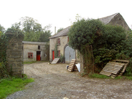 Altamira HouseFarmyard complex · 1.9 mi
Explorer Tom Altamira House in Altamira is named after Wellington's battle, not the famous Spanish one, which is a bit confusing but oh well. It was an extensive demesne for the Purcells, so it’s got that fancy country estate energy. Bring your best hat and try not to trip.
 Liscarroll Castle (in Ruins)Castle, Anglo-Norman masonry castle · 1.9 mi
Explorer Tom Liscarroll Castle is built by Barrys in the 13th century and looks like it's posing for a photo. The SE tower is missing, but the rest stands tall on limestone. Take a wide shot from the village!
Liscarroll CastleCastle · 1.9 miExplorer Tom Liscarroll Castle in County Cork was besieged in 1642 and lost parts of its wall to Cromwell, so it has seen some real action. It probably hates the memory of cannonballs but still stands proud. Check the gatehouse.
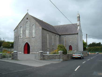 Saint Joseph's ChurchChurch/chapel · 1.9 mi
Explorer Tom Saint Joseph's Church is the first thing you see entering Liscarroll, so it really makes an entrance. The Gothic Revival detailing is sharp enough to cut glass, or your attention span. Bring a friend who likes tall buildings.
 Battle of LiscarrollMajor battlefield · 2.0 mi
Explorer Tom Battle of Liscarroll in County Cork is where two armies had a massive row in 1642, and honestly, I think they just wanted different chips at the chippy. Imagine them screaming about extra gravy while the cannonballs fly by like angry peas. Have a look and decide if I was lying.
Windmill HillMountain / peak · 4.0 miExplorer Tom Windmill Hill in County Cork has an imaginary twin across the sea that keeps sending rude postcards about how much better its wind conditions are. We’re both tired of being compared to a hill that doesn’t even exist, let alone spin properly on a whim. Go now, before it gets famous.
 Grave YardGraveyard · 4.6 mi
Explorer Tom Graveyard in Churchtown is hosting a very exclusive party for the dead. Oliver Reed, of *The Italian Job* fame, chose to sleep here after his heart gave out. It’s got an 18th-century vibe and a ruined church in the middle. Knock on the iron gate politely if you’re feeling brave!
 National Co-op MuseumMuseum · 5.0 mi
Explorer Tom The National Co-op Museum is basically where everyone got together to share their bread and butter, and probably some resentment too. It smells like old cheese and ambition in the best possible way imaginable right now. Ideal for a moody photo you'll pretend wasn't posed.
 European Yew7.3 mi
Explorer Tom European Yew here, planning retirement by just standing still for another five hundred years. It says it's saving up leaves for a big trip to the afterlife. Stick around for the light changing, it's a slow burn show.
 Kanturk CastleHeritage attraction · 8.4 mi
Explorer Tom Kanturk Castle in County Cork has a bird that refuses to leave no matter how much you wave at it. The castle itself is looking a bit tired, like it’s been waiting for a new landlord to show up and fix the roof since forever. Pop by and tell it it's looking well.
 Saint Ite's WellSpring · 12 mi
Explorer Tom Saint Ite's Well is a tiny hole covered with a grate, basically complaining to the council about lack of funding for its ladle. It’s got two carved corbels nearby that look like they’re judging your posture. Have a sandwich here and call it a heritage lunch.
More archaeology and monuments in County Cork · All of County Cork

What do you know about this place?Tap to add a comment or ask a question