Places near here
Photo credits
- National Inventory of Architectural Heritage
- Oliver Dixon, Geograph · CC BY-SA 2.0
- Mick Garratt, Wikimedia Commons · CC BY-SA 2.0
- Keith Salvesen, Geograph · Creative Commons Attribution-ShareAlike 2.0
- Eric Jones, Geograph · CC BY-SA 2.0
- EamonnPKeane at English Wikipedia, Wikimedia Commons · Public domain
- A.-K. D., Wikimedia Commons · CC0
- Colin Park, Geograph · CC BY-SA 2.0
- Graham Horn, Geograph · CC BY-SA 2.0
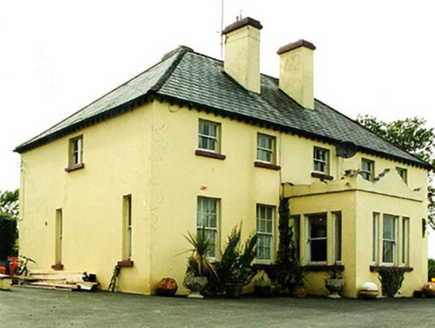 Convent of MercyConvent/nunnery · 1.2 mi
Explorer Tom Convent of Mercy in Leckanvy is watching a poet fall into a ditch nearby with mild interest. It’s all about that neo-Georgian charm, ignoring the mess right outside its front door. If it's closed, admire from a safe distance.
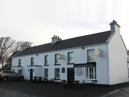 T. StauntonFarm house · 1.3 mi
Explorer Tom T. Staunton farm house in Thornhill is a reconstruction of an old structure that has retained its core identity. It stands there looking very sturdy, as if it’s got a secret recipe for staying put while everything else crumbles around it. The massing is solid and it looks like it could survive a small earthquake or two. Give it a nod from the road.
 Old Head BeachBeach / strand · 1.6 mi
Explorer Tom Old Head Beach in County Mayo hosted a dance that went slightly too far when the moon got involved and started dancing on its own accord. The cliffs were the DJ, playing a soundtrack of crashing waves that nobody asked for but everybody enjoyed anyway. It’s still trying to shake off the embarrassment of having been so lively back then while looking respectable now. Look up, the best bit is
 Ben GoramMountain / peak · 1.7 mi
Explorer Tom Ben Goram is in a feud with the next village over something daft, like who gets to blame the bad weather first. The village insists Ben caused the wind, while Ben says the village’s bad luck brought it. It’s the pettiest argument I’ve ever heard from geological features. Bring a friend who talks too much and let the place shut them up.
 Graveyard2.0 mi
Explorer Tom Graveyard in Kilgeever hates the bumpy road leading to it. The ground keeps settling, so the headstones are always tilting like they’re judging your driving. Bring a flask of something warm and a story to swap.
 Leaba PatrickMemorial · 2.6 mi
Explorer Tom Leaba Patrick is where Padraig allegedly snoozed for forty nights, which is either great discipline or really bad posture. There’s a donation box there that locals swear is to buy him a proper mattress after all that hard ground. I bet he was dreaming of soft cushions while the wind howled around him. If it rains, blame me.
 Croagh PatrickMountain / peak · 2.6 mi
Explorer Tom Fancy a gentle stroll to a chapel? The Reek is laughing already. Croagh Patrick rises like a pointed challenge above Clew Bay, but the people coming here had reasons long before the summit chapel. Nearby Boheh Stone carries more than 260 prehistoric carvings. From that stone, the setting sun seems to roll down the mountain's slope in late April and late August; that is a trick of position and light, and I would happily miss my tea to see it. I might offer Patrick a lift, but he would still have to push me uphill. Tradition says Patrick spent forty days fasting on the Reek. A chapel has stood on the summit since early Christian times, while the present one was dedicated in 1905. On the last Sunday in July, pilgrims still make the climb for Reek Sunday. The usual route begins near Murrisk, but this is a 764 metre mountain, not a chapel with a convenient lift. Bring boots, check the weather and give the pilgrims room. I may be a Donegal chancer, but I will not bargain with a Mayo mountainside.
 National Famine MemorialHeritage attraction · 3.2 mi
Explorer Tom The National Famine Memorial features a sailing ship and skinny people, which is a bold artistic choice for a sunny day. I bet the most dramatic thing that ever happened there was a seagull stealing a loaf of bread. The statue looks like it’s ready to sail off if you blink. Pretend you're a lost aristocrat, nobody will check.
 Croagh Patrick Pilgrim TrailWalking route · 3.3 mi
Explorer Tom Croagh Patrick Pilgrim Trail got the Vikings lost because they kept looking for a port that wasn’t there and ended up walking uphill by accident. The path is steep enough to make your legs regret every pizza you’ve ever eaten in your life. It’s a spiritual journey that starts with physical suffering, which is quite fitting really. Go at sunset and thank me later.
 Dorinish MoreIslet · 3.3 mi
Explorer Tom John Lennon owned an island in Mayo, and I missed the invitation to form a band on it. He bought Dorinish in Clew Bay in 1967 for £1,700. In 1970 he invited Sid Rawle and others to make a commune there; about twenty-five people lived on the small island over the next two years, growing vegetables and raising children. I would have been assigned to the weeding and promptly voted out. A fire destroyed their supply tent in 1972 and the community broke up. Yoko Ono later sold the island and gave the proceeds to an Irish orphanage. Dorinish is uninhabited today and used for grazing, not a public Beatles theme park. Any landing requires proper permission and safe boating conditions; a distant view is enough if those are absent. I will save my Lennon impression for the mainland, where the sheep cannot lodge a complaint.
 InishleagueIslet · 3.4 mi
Explorer Tom Inishleague has a family tree that is mostly invented by people who got lost on their way to the pub. It probably claims to be related to every other rock in Mayo just to sound important at dinner parties. The whole lineage is a bit of a fairy tale spun by someone with too much imagination and not enough coffee. Bring curiosity, leave with a better story than mine.
 Crott MountainMountain / peak · 3.9 mi
Explorer Tom Crott Mountain refuses to fall down because it thinks it has a very strong sense of duty that keeps it glued to the spot. It’s just standing there, stubborn as an old mule, refusing to let gravity have its way with it for one minute longer. The whole vibe is 'I’m not done yet,' even if it looks a bit wobbly in the wind. Go before the tourists find out.
More archaeology and monuments in County Mayo · All of County Mayo

What do you know about this place?Tap to add a comment or ask a question