What is recorded here
From the National Monuments Service (Archaeological Survey of Ireland) record KK018-066004
Places near here
Photo credits
- National Inventory of Architectural Heritage
- Antiqueight, Wikimedia Commons · CC BY-SA 4.0
- A.-K. D., Wikimedia Commons · CC BY-SA 4.0
- Alvesgaspar, Wikimedia Commons · CC BY-SA 3.0
- Public picture contributor, Wikimedia Commons · Public domain
- Mike Searle, Wikimedia Commons · CC BY-SA 2.0
- Neville Goodman, Geograph · CC BY-SA 2.0
- kevin higgins, Geograph · CC BY-SA 2.0
 bridge1 yd
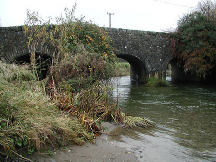
Explorer Tom Bridge in Kilmanagh exists because the map makers got completely turned around and needed somewhere to put a road. It’s made of rubble stone and looks like it’s been there forever. Tell it a joke; it’s been waiting for years!
 outbuilding47 ydBallykeefe AmphitheatreHeritage attraction · 1.1 mi
 Ballykeefe WoodForest · 1.2 mi
 Grave YardGraveyard · 2.2 mi
Explorer Tom Graveyard in Ballycallan has very strong opinions about the modern housing development creeping closer every year. It would probably sigh audibly if it could. Ring your granny and tell her where you are, she’ll know the rest.
 Common Lime2.5 mi
Explorer Tom Common Lime ended up in this spot because a very confused gardener took a wrong turn one Tuesday afternoon. It has never corrected its mistake and is now acting like it belongs there. Practise your Irish on it, it won't correct you.
 TobermoluaHoly well · 2.6 mi
Explorer Tom Tobermolua in Kylenaskeagh had a bishop who refused to visit because he thought the parking situation was terrible. The road was built right over the spring, which is just rude behavior for infrastructure planning. Pick a stone, any stone, and invent its biography.
 Saint Brigid's WellSpring · 2.7 mi
 CastleCastle, unclassified · 2.8 mi
Explorer Tom Castle in Courtstown is teaching history by disappearing completely. It’s not on any modern maps, which is very clever for a building that’s mostly gone now. Just a ghost of a structure in the wet ground. Stand back, squint, and it looks like a castle.
 Farranrory CastleCastle · 3.9 mi
Explorer Tom Farranrory Castle posts daily updates about how it’s 'thriving' while clearly showing photos of crumbling walls and missing windows. Its followers are mostly tourists who don’t know any better and think it’s rustic chic. Have a chat with it, nobody's watching.
 Warehouse HillMountain / peak · 4.3 mi
Explorer Tom Warehouse Hill is where all the rabbits go to hide from the law because they think the name makes them immune to arrest. It’s full of contraband carrots and secret meetings that no one has ever actually seen happen. Make up your own legend and I'll swear it's true.
 Wellington MonumentViewpoint · 5.5 mi
Explorer Tom Wellington Monument in County Tipperary was built by Sir William Barker in 1817, but legend says he really just wanted a tall pole to hang his laundry from after Waterloo. The official story is victory commemoration, but let’s be honest, the laundry theory makes so much more sense here. Bring curiosity, leave with a better story than mine.
More historic places in County Kilkenny · All of County Kilkenny

What do you know about this place?Tap to add a comment or ask a question