
Places near here
Photo credits
- A.-K. D., Wikimedia Commons · CC BY-SA 4.0
- National Inventory of Architectural Heritage
- John Baker, Geograph · CC BY-SA 2.0
- Mike Searle, Wikimedia Commons · CC BY-SA 2.0
- kevin higgins, Wikimedia Commons · CC BY-SA 2.0
- Maker named on the Wikimedia Commons picture page · CC BY-SA 3.0
 Kilmacar Church (in ruins)Church · 79 yd
Explorer Tom Kilmacar Church in Kilmacar would be the uncle at a wedding who stands in the corner talking about plumbing instead of dancing, looking deeply uncomfortable but refusing to leave. It has a pub built right against its back like a very bad codependent relationship that everyone just accepts. Pack a picnic and an excuse.
 Graveyard80 yd
Explorer Tom Graveyard in Kilmacar would tell a job interviewer it has 'excellent views' and 'great team dynamics.' It sits on a slope watching the river go by, feeling very important. Go now, before it gets famous.
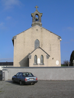 Saint Colman's Catholic ChurchChurch/chapel · 1474 yd
Explorer Tom Saint Colman's Catholic Church is having a quiet rivalry with its neighbour over who looks more mysterious. It built itself like a barn to confuse the architects. Pretend it's yours and tip your hat respectfully.
 Donaghmore WellSpring · 2.0 mi
Explorer Tom Donaghmore Well is famous locally because a giant once tried to drink it all in one go and ended up with a massive belly ache that lasted three days straight. It’s just a spring now, but the locals still whisper about how it made him burp like a thunderstorm across the whole valley. Tell the next person you meet it's haunted. It might be.
 IndicatedBawn · 2.2 mi
Explorer Tom Legend says there was a matchmaker working in this bawn at Foulksrath who paired off knights with ladies based on how well they could juggle apples. The walls are still thick enough to hide all the love letters and secret trysts that happened behind them back in the day. Best enjoyed with a bag of chips and no plans.
Jenkinstown ParkWood · 2.6 miExplorer Tom If Jenkinstown Park had to teach history, it would start with a dramatic pause and then forget everything else happened after Tuesday. It’s basically winging it with a straight face while the trees just nod along politely. Bring a map, get lost anyway, that's the fun.
 Ballyragget Cas.Castle, tower house · 2.8 mi
Explorer Tom Ballyragget Castle thinks the road leading to it is too slow for its taste and keeps sighing audibly. Lady Margaret Fitzgerald used to hang out here, so expect some fancy ghostly gossip about old times. Hang around long enough and you'll hear a story from a local.
 Graveyard in SraleaghGraveyard · 3.1 mi
Explorer Tom Graveyard in Sraleagh would survive a zombie attack just fine because there’s only one inscribed stone left, so they’d run out of targets quickly. It’s basically an easy win for them. Dare you to say hello to it out loud.
.jpg/250px-Junction_and_Buildings_-_geograph.org.uk_-_6511084_(cropped).jpg "Photo: kevin higgins, Wikimedia Commons · CC BY-SA 2.0") RathbeaghFairy fort / earthen ringfort · 3.2 mi
RathbeaghFairy fort / earthen ringfort · 3.2 miExplorer Tom Rathbeagh has an imaginary twin across the sea that probably drinks too much tea and complains about the weather. It’s got a massive bank and zero chill, honestly. Ideal place to rehearse an excuse for being late.
Castlecomer Discovery ParkHeritage attraction · 4.0 miExplorer Tom Castlecomer Discovery Park in County Kilkenny is sick of being asked if the dinosaurs are real, which they absolutely are not, sorry to burst your bubble. It's a heritage attraction that feels like it's waiting for you to grow up or at least wear shoes. Best seen with a hangover and a sausage roll.
 Estate YardMemorial · 4.0 mi
Explorer Tom Estate Yard in County Kilkenny used to run a water-powered mill and a metal foundry, which means it’s been busy as a one-horse open shop for centuries. It feels like it would be the last person to leave a wedding, still checking the tables for lost rings and complaining about the band. Mind the nettles, they’re the real guards here.
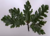 Turkey Oak4.5 mi
Explorer Tom Turkey Oak in County Kilkenny holds a fake world record for being the most confused tree in Ireland, having been misidentified as something else for the last century. It’s not even angry about it, just thoroughly unimpressed by the whole thing. Hang around long enough and you'll hear a story from a local.
More archaeology and monuments in County Kilkenny · All of County Kilkenny

What do you know about this place?Tap to add a comment or ask a question