
Places near here
Photo credits
- Kenneth Allen, Geograph · CC BY-SA 2.0
- National Inventory of Architectural Heritage
- Oliver Dixon, Geograph · CC BY-SA 2.0
- Archaeomoonwalker, Wikimedia Commons · CC BY 3.0
- Pampuco, Wikimedia Commons · CC BY-SA 4.0
- Colin Park, Geograph · CC BY-SA 2.0
- Willie Duffin, Geograph · CC BY-SA 2.0
 Bawn in ArdtermonBawn · 985 yd
Explorer Tom The local sheep have strong opinions about this bawn in Ardtermon. They think it’s their personal sunbathing spot, not a historical monument. The record says nothing, so I’m making this up as I go along. Stop the car, it's worth the hazard lights.
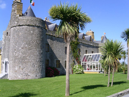 Ardtarmon CastleCastle/fortified house · 985 yd
Explorer Tom Ardtarmon Castle hosted a dance that went so far they still can’t find the shoes. Early seventeenth-century style with all the original features intact, apparently. Nobody knows who left that boot in the corner. Step over it carefully on your way past.
 Castle (in Ruins)House, fortified house · 986 yd
Explorer Tom Ardtermon Castle has a ghost that is too lazy to haunt anyone properly. He just stands in the corner checking his watch for the bus. It’s a fortified house, but feels more like a waiting room. Bring a coin for luck and keep it in your pocket.
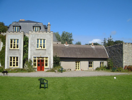 Ardtarmon HouseCountry house · 1081 yd
Explorer Tom Ardtarmon House has been through so many changes it’s like a chameleon in a stone coat of arms. I bet there was a fake royal visit that nobody can prove ever happened, but everyone swears they saw the carriage. It’s got that thatched roof vibe mixed with modern touches, which is quite the mix. Try to spot the different building phases if you’re feeling keen.
 Ardtermon StrandBeach / strand · 1522 yd
Explorer Tom Ardtermon Strand is where two lads in the pub made a bet that started it all, probably about who could walk furthest. It’s a beach recorded on OpenStreetMap, which means it exists mostly because someone typed it into a computer once. The sand is there, the bay is there, and the story is definitely not true. Snap one photo, then put the phone away and actually look.
 Yellow StrandBeach / strand · 1.1 mi
Explorer Tom Yellow Strand is ruled by a goat who hasn't been seen since 1994 but still commands total respect from the surfers. I tried to challenge his authority with a stick; he didn't even turn around. Tell your mates you found it first.
 Horse IslandIslet · 1.8 mi
Explorer Tom Horse Island was built by a man who thought he owned a horse but actually just rented the name for a year. He never paid the rent, so the island has been in legal limbo ever since. If it's closed, admire it from the road like a polite stalker.
 Promontory fortPromontory fort, coastal · 1.9 mi
Explorer Tom Promontory fort in Ballineden is supposedly guarded by a dog who hasn't seen a real threat since the last century but still barks at every passing cloud like it's an intruder. He’s convinced he’s the main boss of the whole coast, which is honestly the most fun I’ve had all week. Bring sandwiches, the gulls will thank you.
 Sligo BayBay · 3.7 mi
Explorer Tom Sligo Bay refuses to be one simple scoop of water, and I am glad, because one view would be too easy. It runs between Aughris Head and Roskeeragh Point. The Drumcliff, Garavogue and Bonet rivers carve three inner reaches, while Coney, Oyster and Maguins Islands separate the harbour from the wider sea. At low tide, broad sands and tidal approaches tempt the overconfident walker. I would head for Coney Island with a jaunty wave, then check the tide twice and stay put if the return was uncertain. Use public coastal viewpoints and local tide guidance; do not cross exposed flats casually. Look for the three island shapes from shore. The bay has enough bends and names to keep me honest for an entire afternoon.
 Waiting on ShoreMemorial · 3.8 mi
Explorer Tom The Waiting on Shore memorial is stuck in eternal suspense, looking at the sea like it’s expecting a delivery that’s been late for centuries. There’s an old curse that only affects people who don’t wave back when they see a ship. Great spot to propose. Or at least to propose lunch.
 Coney IslandIsland · 3.9 mi
Explorer Tom Sligo has a Coney Island too, and I had better specify which one before somebody sends you to New York. Its Irish name recalls the O'Mulclohy family; the English version is the rabbit's claim to fame. In 1862, 124 people lived here and 45 children attended the local school. Electricity did not reach the island by underground cable until 1999, which is a longer wait for a light switch than I would have managed with good manners. Today the island has a tiny permanent population, though summer brings more visitors. You can come across the tidal causeway from the Coolera side when the water is out. That last condition matters more than my confidence about a shortcut: a returning tide can strand a car. Check the local crossing times and signs before going, and make your way back with room to spare. A rabbit might risk another hour; you have a clock and no excuse.
 Oyster IslandIslet · 4.1 mi
Explorer Tom Oyster Island was clearly designed by a mother-in-law who wanted to be close to you but not too close, with that lighthouse watching over everything like a suspicious auntie. It’s got a vibe of 'I know what you're up to,' which is honestly the best personality trait for an island. Bring a pen pal, they'll be jealous.
More archaeology and monuments in County Sligo · All of County Sligo

What do you know about this place?Tap to add a comment or ask a question